Romenay
| Romenay | ||
|---|---|---|
| Commune | ||
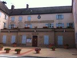 Town hall | ||
| ||
 Romenay Location within Bourgogne-Franche-Comté region  Romenay | ||
| Coordinates: 46°30′13″N 5°04′07″E / 46.5036°N 5.0686°ECoordinates: 46°30′13″N 5°04′07″E / 46.5036°N 5.0686°E | ||
| Country | France | |
| Region | Bourgogne-Franche-Comté | |
| Department | Saône-et-Loire | |
| Arrondissement | Louhans | |
| Canton | Cuiseaux | |
| Area1 | 48.9 km2 (18.9 sq mi) | |
| Population (2006)2 | 1,603 | |
| • Density | 33/km2 (85/sq mi) | |
| Time zone | UTC+1 (CET) | |
| • Summer (DST) | UTC+2 (CEST) | |
| INSEE/Postal code | 71373 /71470 | |
| Elevation |
172–214 m (564–702 ft) (avg. 204 m or 669 ft) | |
|
1 French Land Register data, which excludes lakes, ponds, glaciers > 1 km2 (0.386 sq mi or 247 acres) and river estuaries. 2 Population without double counting: residents of multiple communes (e.g., students and military personnel) only counted once. | ||

Romenay is a commune in the Saône-et-Loire department in the region of Bourgogne in eastern France.
It is a pretty medieval town surrounded by ancient walls with its typical church at the centre of town.
See also
References
| Wikimedia Commons has media related to Romenay. |
This article is issued from
Wikipedia.
The text is licensed under Creative Commons - Attribution - Sharealike.
Additional terms may apply for the media files.