Ilhéu das Rolas
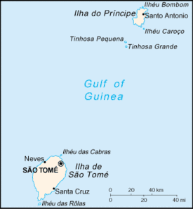 Map of São Tomé and Príncipe | |
| Geography | |
|---|---|
| Location | São Tomé and Príncipe |
| Coordinates | 0°00′14″S 6°31′21″E / 0.003777°S 6.522388°ECoordinates: 0°00′14″S 6°31′21″E / 0.003777°S 6.522388°E |
| Area | 3 km2 (1.2 sq mi) |
| Administration | |
| Demographics | |
| Demonym | Rolense |
| Population | 439 (2017) |
| Ethnic groups | Caué |
Ilhéu das Rolas is an islet in São Tomé and Príncipe, in Africa. The island lies on the equator, off the southern tip of São Tomé Island separated by Canal das Rolas. It is in the Caué District of São Tomé Province. The island is home to a small resort, the Pestana Equador.
Population history
| Historical population | ||
|---|---|---|
| Year | Pop. | ±% |
| 2001 (census) | 224 | — |
| 2017 (estimate) | 439 | +96.0% |
About the islet
The main and dominant economic activity is tourism, related mainly to the resort. A permanent population of approximately 400 people works in the island's tourism sector. The center of the settlement may be the closest to the Equator on the planet.
The island can only be accessed by boat departing from São Tomé Island at the port near Ponta Baleia, its small port is near Pestana Equador, one of the closest water ports of any size to the equator. It is the only islet with roads in the nation that do not allow motor vehicles. Not the only one in the part of the islands off the African mainland, other examples are Lobos of the Canary Islands and the uninhabited island of Santa Luzia of Cape Verde, the latter without a ferry route.
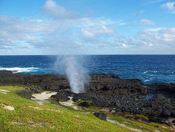
Much of the southern part is in the Southern Hemisphere, its total area of that portion covering over 80% of the island covers 5 square kilometres (1.9 sq mi) of the islet and only less than 1% of the nation. The island has a small geyser named Furnas. Numerous beaches dominates including one by the resort, Santo António and Café, Pesqueira das Rolas, Pombo, Escada and Santo Antônio (or António).
The islet also has a lighthouse (better as Ilhéu das Rolas and not Gago Coutinho), it was built in 1929, over a decade after the completion of an equator monument, located in Pestana Equador. As it sits on a hill, its focal height is 106 meters and its range is about 20 km (12 nmi). It is located in the Northern Hemisphere and is not far from the opposite hemisphere.[1]
History
The current islet was formed likely from a smaller vent of the same seamount as the nearby island to the north.
During the Ice Age when the sea level was 130 meters lower than the present day, it formed a part of the island of São Tomé and were small mountains, during the Late Ice Age, it separated from the island and became an islet.
As with the island, the islet was discovered by Portuguese explorers João de Santarém and Pêro Escobar between 1469 and 1471 on Saint Thomas' feast day.
In its maps between the 16th and the 19th centuries, the Equator was thought to be marked in the middle of the island and from the mid-17th century, at Porto Alegre and from the 19th century, at the channel separating the island and the islet.
The islet name were mentioned as "Ilhé das Rolas" in the 1616 map by Jodocus Hondius,[2] as "Illie de Rolle" in the 1665 map by Johannes Vingboons.[3] and as "I. de Rolle" in the 1780 map by A. Dalrymple.[4] Also it was mentioned in a 1902 map, the map also displayed today at an info wall at Roça de Porto Alegre on the nearby island of São Tomé.
Confirmation of equatorial position
Gago Coutinho (1869–1959), officer of the Portuguese Navy, navigator and historian, headed a geodesic mission to São Tomé between 1915 and 1918, when marks were placed as a basis for a geodetic network in the archipelago. After that, observations for triangulation, precise base measurement and astronomical observations were made.
In the process, Gago Coutinho proved that Ilhéu das Rolas is crossed by the equatorial line. The resulting map was published in 1919, together with the Report of the Geodetic Mission on São Tomé Island 1915–1918, that was officially considered the first complete work of practical geodesy in the Portuguese colonies.
Nature
The islet are abundant in flora and fauna, common (some of these also founded in the African mainland) and endemic (that forming the majority), as well as its surrounding shallow and part shallow waters and deeper waters around 10 km outward. Fauna on land includes Greeff’s giant gecko, and birds such as the São Tomé prinia, green pigeon and the weaver and frogs such as Phrynobatrachus leveleve and Schistometopum thomense.
During the Ice Age, their habitats were part of the island of São Tomé and animals and insects went from/into the area that was once part of the island and areas to the north. When it separated from the islet, some of these were cut off from the island leaving the birds continuing to have habitat in both the islet and the island. Marine fauna dominate the waters surrounding the islet, fishes include Gorogobius stevcici.
Gallery
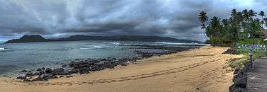
.jpg) Praia de Santo António
Praia de Santo António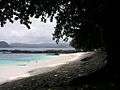 Beach scenery in São Tomé and Príncipe
.jpg) Ilhéu das Rolas, STP
Ilhéu das Rolas, STP.jpg) Ilhéu das Rolas
Ilhéu das Rolas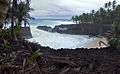 São Tomé and Príncipe
.jpg) STP
STP.jpg) Beach close to Ilhéu das Rolas, São Tomé and Príncipe
Beach close to Ilhéu das Rolas, São Tomé and Príncipe
References
- ↑ "Sao Tome & Principe". ARLHS World of Lights (WLOL). Amateur Radio Lighthouse Society. April 8, 2009. Retrieved 4 May 2017.
- ↑ 1616 map of the island of Saint Thomas (now São Tomé) by Jodocus Hondius, now at the French National Library
- ↑ 1665 map of the island of Saint Thomas (now São Tomé) by Johannes Vingboons, now at the Dutch National Archive
- ↑ 1780 map of the island of Saint Thomas (now São Thomé) by T. Harmar and A. Dalrymple, now at the French National Library
Further reading
| Wikimedia Commons has media related to Ilhéu das Rolas. |
- Great World Atlas, Reader´s Digest Selections, 1st ed, September 2006, p. 223. ISBN 972-609-471-2
- Grande Dicionário Enciclopédico Ediclube Vol. XVI, p. 5574 e 5575. 1996. ISBN 972-719-056-1
| Major islands | |
|---|---|
| Minor islands and islets | |
| Communities | 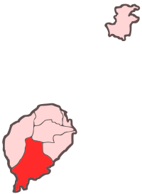 | |
|---|---|---|
| Geographical features | ||
| Landmarks and hotels | ||
| Culture | ||