Canal das Rolas
| Canal das Rolas | |
|---|---|
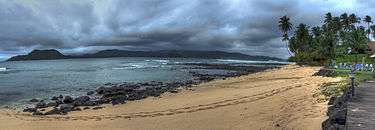 Canal das Rolas as seen from Ilhéu das Rolas | |
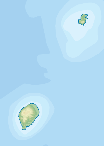 Canal das Rolas Location in São Tomé and Príncipe | |
| Coordinates | 0°01′N 6°31′E / 0.01°N 6.52°ECoordinates: 0°01′N 6°31′E / 0.01°N 6.52°E |
| Ocean/sea sources | Atlantic Ocean |
| Basin countries | São Tomé and Príncipe |
| Max. length | 2.5 km (1.6 mi) |
| Max. width | 2 km (1.2 mi) |
| Islands | Ilhéu das Rolas |
| Settlements |
Porto Alegre Ilhéu das Rolas |
The Canal das Rolas ("Rolas Channel") is a channel of the Atlantic Ocean separating the islands of São Tomé and the small Ilhéu das Rolas in São Tomé and Príncipe.
Geography
Its length is about 2.5 km from east to west and at its narrowest point, it is 2 km wide from north to south and 2.5 km from the northernmost point of the islet named Santo Antônio to a point east of Praia Inhame.[1] The channel includes the southernmost point of the island of São Tomé, north of the channel is Baía de Iago Iago whose name is of Angolan origin. The non-motorized ferry route crosses the east of the channel linking the islet with São Tomé at Ponta Baleia. Two places lie next to the channel, Ilhéu das Rolas (or Marca do Equador) and Porto Alegre. A few beaches surrounds the channel, one Praia Inhame, Cabana and Nguembu on São Tomé Island and Santo Antônio in the northeast of Ilhéu das Rolas as well as another to the west, nearby the islet's point is Pestana Equador. East of the channel is Sete Pedras and northeast is a bay named Praia Grande surrounding the southern tip of the island.
The bay is predominantly shallow with the western portion forming a reef (the deepest being around 3 m), whereas the ferry route bypasses to the east at slightly deeper waters of about 15 m deep, that area being the deepest part of the channel and may be one of the shallowest channels in the South Atlantic Ocean.
History
During the Ice Age, the area was land and forested and formed a part of São Tomé Island, as sea level rose thousands of years ago, it was reduced to an isthmus and the east became a bay and then, the channel was formed about 7,000 to 6,000 years ago and was just about 100 m wide, then a kilometer wide. Land fauna used to dominate the area, other than birds, some of them were Greeff’s giant gecko, and frogs such as Phrynobatrachus leveleve and Schistometopum thomense, as these species today are also founded on the islet.
As with the island and the islet, the body of water was discovered by Portuguese explorers João de Santarém and Pêro Escobar between 1469 and 1471 on Saint Thomas' feast day. It was later name and was commonly named as a road, later it would be as a channel.
The water feature were mentioned as "Rede van t'Eylandt" (Modern Dutch: "Rede van der Eiland") in the 1665 map by Johannes Vingboons.[2] and as "The Road of the Island" in the 1780 map by A. Dalrymple.[3] Also display on those maps was the Equator which was thought to be at the island's headland thought to be "south" and the channel thought to be in the Northern Hemisphere. Later maps would figure the Equator at the southcentre of the channel and the islet being south of the island. One of them were 1902 map, the map also displayed today at a info wall at Roça de Porto Alegre on the nearby island of São Tomé. Its marking was not correct until a geodesic mission between 1915 and 1918 and runs in the north of the islet near the village, including the southernmost area of the channel.
Nature
At of the channel, sea life dominates the underwater portion. It has one of the most numerous sea fauna within the island and has fishes, crustaceans, corals, as well as molluscs including octopus, sea snails and sea slugs. Birds are the only land fauna of the channel, these cross the island and the islet, some of the them the ocean and other parts of Gulf of Guinea Islands.
References
- ↑ GoogleEarth
- ↑ 1665 map of the island of Saint Thomas (now São Tomé) by Johannes Vingboons, now at the Dutch National Archive
- ↑ 1780 map of the island of Saint Thomas (now São Thomé) by T. Harmar and A. Dalrymple, now at the French National Library
| Communities | 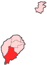 | |
|---|---|---|
| Geographical features | ||
| Landmarks and hotels | ||
| Culture | ||