Kupa
| Kupa / Kolpa | |
|---|---|
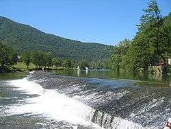 Kolpa at Prelesje (Slovenia) | |
| Country | Croatia, Slovenia |
| Physical characteristics | |
| Main source |
Razloge, Gorski kotar, Croatia 313 metres (1,027 ft) [1] |
| River mouth |
Sava, Sisak, Croatia 45°27′36″N 16°24′08″E / 45.46000°N 16.40222°ECoordinates: 45°27′36″N 16°24′08″E / 45.46000°N 16.40222°E |
| Length | 297.4 km (185 mi) [2][3] |
| Discharge |
|
| Basin features | |
| Progression | Sava→ Danube→ Black Sea |
| Basin size | 10,226 km2 (3,948 sq mi) [2] |
The Kupa (Croatian and Serbian pronunciation: [kûpa]) or Kolpa (Slovene pronunciation: [ˈkóːlpa] or [ˈkóːwpa]; from Latin: Colapis in Roman times) river, a right tributary of the Sava, forms a natural border between north-west Croatia and southeast Slovenia. It is 297 kilometres (185 miles) long,[2] with its border part having a length of 118 km (73 mi)[1] and the rest located in Croatia.[4]
The name "Colapis" is supposed to come from Proto-Indo-European words *kwol and *h2ep, so that it means "water with meanders".[5]

Course

The Kupa originates in Croatia in the mountainous region of Gorski Kotar, northeast of Rijeka, in the area of Risnjak National Park. It flows a few kilometers eastwards, receives the small Čabranka River from the left, before reaching the Slovenian border.
It then continues eastwards between the White Carniola region in the north and Central Croatia in the south. The Kupa receives influx from the river Lahinja from the left in Primostek, passes Vrbovsko, and eventually detaches from the Slovenian border having passed Metlika.
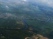
It then reaches the city of Karlovac, where it receives influx from two other rivers from the right, Dobra and Korana (which in turn is joined by Mrežnica). The Kupa continues flowing to the east, where it merges with Glina from the right as well as Odra from the left, it then passes through two small towns called Šišinec and Brkiševina, and then proceeds to the town of Sisak where it flows into the Sava River.
Pollution
Fairly unpolluted downstream to Karlovac, the upper Kupa is a popular place for bathing in summer. The section from Stari Trg down to Fučkovci since 2006 is part of the Slovenian Krajinski park Kolpa nature reserve.
The hydrological parameters of the Kupa are regularly monitored at Radenci, Kamanje, Karlovac and Jamnička Kiselica.[6]
References
- 1 2 Rivers, longer than 25 km, and their catchment areas, Statistical Office of the Republic of Slovenia
- 1 2 3 "Sava River Basin Analysis Report" (PDF, 9.98 MB). International Sava River Basin Commission. September 2009. p. 13. Retrieved 2018-05-18.
- ↑ Ostroški, Ljiljana, ed. (December 2015). Statistički ljetopis Republike Hrvatske 2015 [Statistical Yearbook of the Republic of Croatia 2015] (PDF). Statistical Yearbook of the Republic of Croatia (in Croatian and English). 47. Zagreb: Croatian Bureau of Statistics. p. 49. ISSN 1333-3305. Retrieved 27 December 2015.
- ↑ Surface streams and water balance of Slovenia, Ministry of the Environment and Spacial Planning
- ↑ http://linguistforum.com/outside-of-the-box/croatian-toponyms/
- ↑ "Daily hydrological report". Croatian Meteorological and Hydrological Service. Retrieved 2010-09-05.
External links
| Wikimedia Commons has media related to Kupa. |
- source of Kupa pictures
- Panoramic of the source
- Awarded "EDEN - European Destinations of Excellence" non traditional tourist destination 2010
Hydrography of Slovenia | ||
|---|---|---|
| Rivers |
|  |
| Streams | ||
| Waterfalls | ||
| Lakes | ||
| Wetlands | ||
| Sea | ||
| River valleys |
| |
| Canyons and gorges |
| |