Boljunčica
| Boljunčica | |
|---|---|
 | |
| Country | Croatia |
| Physical characteristics | |
| River mouth |
Adriatic Sea 45°08′00″N 14°10′40″E / 45.1332°N 14.1778°ECoordinates: 45°08′00″N 14°10′40″E / 45.1332°N 14.1778°E |
| Length | 33 km (21 mi)[1] |
| Basin features | |
| Basin size | 230 km2 (89 sq mi)[1] |
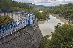
Boljunčica is a river in inland Istria, Croatia. It discharges into the Adriatic Sea near Plomin. It is 33 kilometres (21 mi) long and it has a basin with an area of 230 square kilometres (89 sq mi). Its average discharge at the measurement station in Polje Čepić (covering 183 km2 of the basin) is 0.956 m3/s, and it can go completely dry.[1]
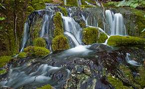
Boljunčica rises on the western slopes of the Učka mountain and flows to the south. Near Polje Čepić and Potpićan, it goes underground and emerges near Plomin.
References
- 1 2 3 "Karakteristike značajnijih vodotoka". Vodnogospodarska osnova Hrvatske - Strategija upravljanja vodama (in Croatian). Croatian Parliament. Retrieved 2011-12-18.
This article is issued from
Wikipedia.
The text is licensed under Creative Commons - Attribution - Sharealike.
Additional terms may apply for the media files.