Kamnik Bistrica
| Kamnik Bistrica | |
|---|---|
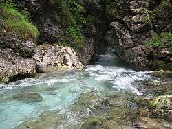 The upper course of the Kamnik Bistrica as it enters the Predoselj Gorge | |
| Country | Slovenia |
| Physical characteristics | |
| Main source |
near the Kamnik Bistrica Lodge, Kamnik–Savinja Alps 600 m (2,000 ft) [1] 46°19′40.4″N 14°35′14.68″E / 46.327889°N 14.5874111°E |
| River mouth |
the Sava, near Videm east of Ljubljana 261 m (856 ft) [1] 46°04′34″N 14°38′19″E / 46.0760°N 14.6387°ECoordinates: 46°04′34″N 14°38′19″E / 46.0760°N 14.6387°E |
| Length | 33 km (21 mi) [1] |
| Discharge |
|
| Basin features | |
| Progression | Sava→ Danube→ Black Sea |
| Basin size | 530 km2 (200 sq mi) [1] |
| Tributaries |
|
The Kamnik Bistrica[2][3][4] (Slovene: Kamniška Bistrica, pronounced [ˈkáːmniʃka ˈbíːstritsa])[5] is an Alpine river in northern Slovenia, a left tributary of the Sava River. It springs from the Kamnik Alps (part of the Southern Limestone Alps) near the border with Austria. It is 33 km (21 mi) long.[1] The Kamnik Bistrica flows through the town of Kamnik, where it is fed by the Nevljica River. It flows into the Sava south of Videm, about 10 km east of Ljubljana.
References
- 1 2 3 4 5 Rivers, longer than 25 km, and their catchment areas, Statistical Office of the Republic of Slovenia
- ↑ Poe, Anne; Poe, Mike. "Cycle Scenic Slovenia". Take A Hike Guidebooks. Retrieved July 26, 2018.
- ↑ "Hiking package". Terme Snovik. Retrieved July 26, 2018.
- ↑ "Escape the Cold and Get 'Hygge' With pitchup.com's Cosy Picks". TravMedia. Retrieved July 26, 2018.
- ↑ "Slovenski pravopis 2001: Kamniška Bistrica".
External links

- Condition of the Kamnik Bistrica - graphs, in the following order, of water level, flow and temperature data for the past 30 days (taken in Kamnik, downstream from the confluence with Nevljica by ARSO)
Hydrography of Slovenia | ||
|---|---|---|
| Rivers |
|  |
| Streams | ||
| Waterfalls | ||
| Lakes | ||
| Wetlands | ||
| Sea | ||
| River valleys |
| |
| Canyons and gorges |
| |
This article is issued from
Wikipedia.
The text is licensed under Creative Commons - Attribution - Sharealike.
Additional terms may apply for the media files.