Tunjščica
| Tunjščica | |
|---|---|
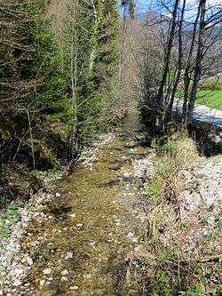 Tunjščica in Laniše | |
| Country | Slovenia |
| Physical characteristics | |
| Main source |
South slope of Mount Krvavec in the Kamnik–Savinja Alps 750 m (2,460 ft) |
| River mouth |
Pšata in Moste 46°11′41″N 14°32′50″E / 46.1948°N 14.5473°ECoordinates: 46°11′41″N 14°32′50″E / 46.1948°N 14.5473°E |
| Length | 14 km (8.7 mi) |
| Basin features | |
| Progression | Pšata→ Kamnik Bistrica→ Sava→ Danube→ Black Sea |
Tunjščica (also known locally as Tunjica Creek)[1][2] is a left tributary of the Pšata River in Slovenia. It is about 14 kilometers (8.7 mi) long and has its origin at 750 meters (2,460 ft) above sea level on the south slope of Mount Krvavec in the Kamnik–Savinja Alps above the hamlet of Senožeti in Sveti Lenart. It flows past or through Sidraž, Laniše, Tunjice, Tunjiška Mlaka, and Gora pri Komendi before emptying into the Pšata at Moste.[3][4] Tributaries of Tunjščica Creek include Praproščica Creek (a.k.a. Prapretčica Creek).
References
- ↑ Stališča do pripomb in predlogov - Občina Komenda. No. 35000-0001/2011, 12 May 2013.
- ↑ Savnik, Roman, ed. 1971. Krajevni leksikon Slovenije, vol. 2. Ljubljana: Državna založba Slovenije, p. 189.
- ↑ Savnik, Roman, ed. 1968. Krajevni leksikon Slovenije, vol. 1. Ljubljana: Državna založba Slovenije. p. 167.
- ↑ Savnik, Roman, ed. 1971. Krajevni leksikon Slovenije, vol. 2. Ljubljana: Državna založba Slovenije, pp. 177, 187, 189, 198.
External links
Hydrography of Slovenia | ||
|---|---|---|
| Rivers |
|  |
| Streams | ||
| Waterfalls | ||
| Lakes | ||
| Wetlands | ||
| Sea | ||
| River valleys |
| |
| Canyons and gorges |
| |
This article is issued from
Wikipedia.
The text is licensed under Creative Commons - Attribution - Sharealike.
Additional terms may apply for the media files.