Zrmanja
| Zrmanja | |
|---|---|
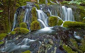
 Misije, a source of Zrmanja River | |
| Country |
|
| Physical characteristics | |
| River mouth |
Adriatic Sea 44°12′06″N 15°35′18″E / 44.2017°N 15.5883°ECoordinates: 44°12′06″N 15°35′18″E / 44.2017°N 15.5883°E |
| Length | 69 km (43 mi)[1] |
| Basin features | |
| Basin size | 907 km2 (350 sq mi)[1] |
Zrmanja (pronounced [zř̩maɲa]) is a river in southern Lika and northern Dalmatia, Croatia. It is 69 km (43 mi) long and its basin covers an area of 907 km2 (350 sq mi).[1]
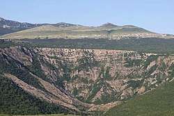
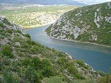
It was known to the ancient Romans as Tedanius. The spring of Zrmanja is located in southern part of Lika under Postak - the southern peak of Pljesevica mountain, and close to south end of Velebit mountain. It is characteristic for its spring located on the bottom of very steep, almost 200 m high funnel shape rock called Misije. It flows southward through the narrow and long arable valley which encircles the southern end of Velebit through a 200-metre-deep canyon, and then turns westwards, reaches Obrovac, and after a few kilometers flows into the Adriatic Sea in the bay named Novigradsko more.
In the late 1980s the Riverfree Club and Huck Finn Adventure Company pioneered commercial canoe, kayak and raft trips - one-day excursions and multi-day tours with camping. In the 1990s the Velebit area was declared a nature park. Rafting trips on Zrmanja take place in spring and autumn, while kayaks and canoes are used during low water level period of July and August.
References
- 1 2 3 Statistical Yearbook of the Republic of Croatia 2017 (PDF) (in Croatian and English). Zagreb: Croatian Bureau of Statistics. December 2017. p. 47. ISSN 1333-3305. Retrieved 23 May 2018.