Bednja (river)
| Bednja | |
|---|---|
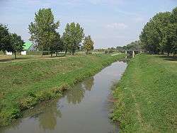 The Bednja in Ludbreg. | |
| Country | Croatia |
| Physical characteristics | |
| River mouth |
Drava 46°18′12″N 16°45′23″E / 46.3033°N 16.7564°ECoordinates: 46°18′12″N 16°45′23″E / 46.3033°N 16.7564°E |
| Length | 133 km (83 mi)[1] |
| Basin features | |
| Progression | Drava→ Danube→ Black Sea |
| Basin size | 966 km2 (373 sq mi)[1] |
The Bednja (Croatian pronunciation: [bêdɲa]) is a river in northern Croatia, a right tributary of the Drava. It is 133 kilometres (83 mi) long and its basin covers an area of 966 square kilometres (373 sq mi).[1] The Bednja rises in the mountainous forested areas near Macelj in northern Croatia, west of Trakošćan, where it also forms a 0.2 km2 (0.077 sq mi) lake at 255 m.a.s.l..[1] It flows towards the southeast until turning east near Bednja, meandering south at Novi Marof, returning to its eastward course shortly thereafter, and then turning northeast toward Ludbreg. It flows into the Drava River north of Mali Bukovec, at 46°18′12″N 16°45′23″E / 46.303333°N 16.756389°E.
It was called "Serapia" in antiquity. The name "Serapia" is supposed to come from Proto-Indo-European words *ser (to flow) and *h2ep (water).[2]
References
- 1 2 3 4 Statistical Yearbook of the Republic of Croatia 2017 (PDF) (in Croatian and English). Zagreb: Croatian Bureau of Statistics. December 2017. p. 47. ISSN 1333-3305. Retrieved 23 May 2018.
- ↑ http://linguistforum.com/outside-of-the-box/croatian-toponyms/