Odra (Kupa)
| Odra | |
|---|---|
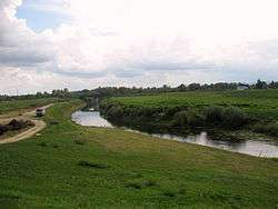 Odra near Sisak | |
| Country | Croatia |
| Physical characteristics | |
| River mouth |
Kupa 45°29′39″N 16°21′17″E / 45.4943°N 16.3546°ECoordinates: 45°29′39″N 16°21′17″E / 45.4943°N 16.3546°E |
| Length | 83 km (52 mi)[1] |
| Basin features | |
| Progression | Kupa→ Sava→ Danube→ Black Sea |
| Basin size | 604 km2 (233 sq mi)[1] |
Odra (pronounced [odra]) is a river in central Croatia. It is 83 km (52 mi) long and its basin covers an area of 604 km2 (233 sq mi).[1] Its source is in the Žumberak mountain, southwest of Zagreb. It flows eastwards, passes south of Velika Gorica, then turns south-east, more or less parallel to the river Sava. It flows into the river Kupa near Odra Sisačka, just northeast of Sisak, also just before the Kupa joins the river Sava.
The upper flow of Odra has been significantly altered by humans, by the digging of the 32 km (20 mi) long canal Sava-Odra(-Sava) south of Zagreb, as a measure against flooding (first put to use in 1979).[2]
There are several etymologies suggested for the name "Odra". One is that it comes from the Croatian word "oderati" (to cut through). The other is that it comes from the Indo-European root *wodr (water).
References
- 1 2 3 Statistical Yearbook of the Republic of Croatia 2017 (PDF) (in Croatian and English). Zagreb: Croatian Bureau of Statistics. December 2017. p. 47. ISSN 1333-3305. Retrieved 23 May 2018.
- ↑ Stjepan Šterc. "Kanal Sava-Odra-Sava kao objekt obrane Zagreba od poplava" [Zagreb flood defences by the Sava—Odra—Sava canal]. Geografski glasnik (in Croatian). Zagreb: Hrvatsko geografsko društvo - Croatian Geography Society (41–42, 1979–80). Retrieved 2010-10-17. (includes English language summary)