Sava Dolinka
| Sava Dolinka | |
|---|---|
 Zelenci Springs, the source of the Sava Dolinka | |
| Country | Slovenia |
| Physical characteristics | |
| River mouth |
Sava 46°20′39″N 14°09′19″E / 46.3442°N 14.1553°ECoordinates: 46°20′39″N 14°09′19″E / 46.3442°N 14.1553°E |
| Length | 45 km (28 mi) [1] |
| Basin features | |
| Progression | Sava→ Danube→ Black Sea |
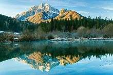
The Sava Dolinka is a headwater of the Sava River in northwestern Slovenia. The 45 kilometres (28 mi) long Sava Dolinka[1] starts as Nadiža Creek in the Planica Valley under Mount Zadnja Ponca in the Julian Alps, at an elevation of 1222 m, close to the Italian border. The stream goes underground soon after its source and breaks out again after 5 km at an elevation of 842 m in Zelenci, near Kranjska Gora. The Sava Dolinka flows through Kranjska Gora, Gozd Martuljek, Jesenice, between Bled and Breg, and past the town of Lesce. The first in a series of hydroelectric power plants on the river, the Moste Hydro Power Plant (22.5 MW), is located near Žirovnica. It merges with the second major headwater of the Sava, the Sava Bohinjka, at Radovljica. A notable tributary of the Sava Dolinka is the Radovna, which flows through the Vintgar Gorge near Bled.
References
- 1 2 "Sava River Basin Analysis Report" (PDF, 9.98 MB). International Sava River Basin Commission. September 2009. p. 12. Retrieved 2018-05-18.
External links
| Wikimedia Commons has media related to Sava Dolinka. |
- Condition of Sava Dolinka - graphs, in the following order, of water level, flow and temperature data for the past 30 days (taken in Blejski Most by ARSO)
Hydrography of Slovenia | ||
|---|---|---|
| Rivers |
|  |
| Streams | ||
| Waterfalls | ||
| Lakes | ||
| Wetlands | ||
| Sea | ||
| River valleys |
| |
| Canyons and gorges |
| |