Plitvica (river)
| Plitvica | |
|---|---|
 | |
| Country | Croatia |
| Physical characteristics | |
| River mouth |
Drava 46°18′29″N 16°44′14″E / 46.3081°N 16.7373°ECoordinates: 46°18′29″N 16°44′14″E / 46.3081°N 16.7373°E |
| Length | 65 km (40 mi)[1] |
| Basin features | |
| Progression | Drava→ Danube→ Black Sea |
| Basin size | 272 km2 (105 sq mi)[1] |
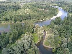
Plitvica is a river in northern Croatia, a right tributary of Drava. It is 65 kilometres (40 mi) long and its basin covers an area of 272 square kilometres (105 sq mi).[1]
Plitvica rises in the hilly areas of Maceljsko gorje, near of the eponymous village of Plitvica Voćanska, near Donja Voća. It flows southeast until it turns east near Maruševec, and continues through the lowland south of Varaždin and parallel to Drava, through Sveti Đurđ (north of Ludbreg), until it merges into Drava north of Veliki Bukovec.
References
- 1 2 3 Statistical Yearbook of the Republic of Croatia 2017 (PDF) (in Croatian and English). Zagreb: Croatian Bureau of Statistics. December 2017. p. 47. ISSN 1333-3305. Retrieved 23 May 2018.
This article is issued from
Wikipedia.
The text is licensed under Creative Commons - Attribution - Sharealike.
Additional terms may apply for the media files.