Reka (river)
| Reka | |
|---|---|
 | |
| Country | Croatia, Slovenia |
| Physical characteristics | |
| River mouth |
Škocjan Caves 45°39′49″N 13°59′54″E / 45.66361°N 13.99833°ECoordinates: 45°39′49″N 13°59′54″E / 45.66361°N 13.99833°E |
| Length | 54 km (34 mi) [1] |
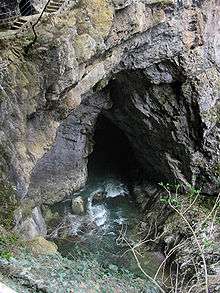
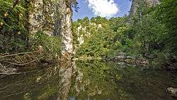
The Reka (literally, 'river' in Slovene), also the Inner Carniola Reka (Slovene: Notranjska Reka),[2][3] is a river that starts as Big Creek (Croatian: Vela voda) in Croatia, on the southern side of Mount Snežnik, and flows through western Slovenia, where it is also initially known as Big Creek (Velika voda).[4] The river is 54 kilometres (34 mi) long, of which 51 km in Slovenia.[1] At the village of Škocjan it disappears underground through Škocjan Caves (a UNESCO World Heritage Site), flowing 38 km (24 mi) underneath the Slovenian Karst. The river continues as part of the Timavo in Italy, however, tracer studies have shown that it also feeds springs elsewhere on the Adriatic Coast between Trieste and Monfalcone.[5] It has the pluvial regime.[6]
References
- 1 2 Rivers, longer than 25 km, and their catchment areas, Statistical Office of the Republic of Slovenia
- ↑ Lazar, Jože. 1975. Razširjenost sladkovodnih alg v Sloveniji. Ljubljana: SAZU, p. 13.
- ↑ Hrvatin, Mauro, Helena Dobrovoljc, Jerneja Fridl, Janez Mulec, & Miha Pavšek. 2008. Kras. Ljubljana: ZRC, p. 35.
- ↑ Perko, Drago, & Milan Orožen Adamič. 1998. Slovenija: pokrajine in ljudje. Ljubljana: Mladinska knjiga, p. 251.
- ↑ LTER Slovenia summarizes the science performed to date: http://lter.zrc-sazu.si/ProjectOverview/tabid/350/Default.aspx
- ↑ Brečko Grubar,, Valentina; Kovačič, Gregor (2010). "Pokrajinskoekološka oznaka jadranskega povodja v Sloveniji s poudarkom na kakovosti vodnih virov" [Landscape Ecological Characterization of the Adriatic Sea Basin in Slovenia with an Emphasis on Water Resource Quality]. Annales. Series historia et sociologia (in Slovenian). 20 (1): 153–168.
External links

- Condition of Reka at Cerkvenikov Mlin and Škocjan - graphs, in the following order, of water level and flow data for the past 30 days (taken by ARSO)
Hydrography of Slovenia | ||
|---|---|---|
| Rivers |
|  |
| Streams | ||
| Waterfalls | ||
| Lakes | ||
| Wetlands | ||
| Sea | ||
| River valleys |
| |
| Canyons and gorges |
| |