Qiemo County
| Qiemo County 且末县 • چەرچەن ناھىيىسى | |
|---|---|
| County | |
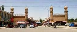 Main entrance of a bazaar in the county seat of Qiemo | |
.png) Location of Qiemo County (pink) in Bayingolin Prefecture (yellow) and Xinjiang | |
 Qiemo Location of the county seat in Xinjiang | |
| Coordinates: 38°08′N 85°31′E / 38.133°N 85.517°ECoordinates: 38°08′N 85°31′E / 38.133°N 85.517°E | |
| Country | People's Republic of China |
| Region | Xinjiang |
| Autonomous prefecture | Bayingolin |
| Area | |
| • Total | 138,645 km2 (53,531 sq mi) |
| Time zone | UTC+8 (China Standard) |
| Qiemo County | |||||||||||
| Chinese name | |||||||||||
|---|---|---|---|---|---|---|---|---|---|---|---|
| Simplified Chinese | 且末县 | ||||||||||
| Traditional Chinese | 且末縣 | ||||||||||
| |||||||||||
| Alternative Chinese name | |||||||||||
| Simplified Chinese | 恰尔羌县 | ||||||||||
| Traditional Chinese | 恰爾羌縣 | ||||||||||
| |||||||||||
| Uyghur name | |||||||||||
| Uyghur |
قاغىلىق ناھىيىسى | ||||||||||
| |||||||||||
Qiemo County (Chinese: 且末县) as the official romanized name, also transliterated from Uyghur as Qarqan County (Uyghur: چەرچەن ناھىيىسى ; Chinese: 恰尔羌县), is a county under the administration of the Bayin'gholin Mongol Autonomous Prefecture in the Xinjiang Uyghur Autonomous Region of the People's Republic of China, bordering the Tibet Autonomous Region to the south. Its area is 138,645 square kilometres (53,531 sq mi) and, according to the 2002 census, it has a population of 60,000. The county seat is at Qiemo Town.
Name
"Qiemo (W-G: Ch'ieh-mo) 且末 = modern Cherchen or Charchan (Uyghur: Qarqan). There has been uncertainty about this name as Chavannes (1907), p. 156, and then Stein (1921a), Vol. I, 296 ff., gave an incorrect romanization for the first character. Chavannes, using the French EFEO romanisation system, gave tsiu, and Stein used the Wade-Giles equivalent, chü. In fact, the character is correctly rendered k’ie in EFEO, ch’ieh in Wade-Giles and qie in pinyin. Nevertheless, there has never been any serious dispute about its identification with modern Cherchen."[1]
It has been suggested that the name "Cherchen" may have been derived from Shanshan, the kingdom that once ruled the area.[2] A number of different names have been used for the town, Lionel Giles has recorded the following names for Ruoqiang Town (with his Wade-Giles forms of the Chinese names converted to pinyin):
- Jumo Han
- Zuomo (左末) Song Yun
- Jumo Jun [Sui]
- Zhemotuona (折摩馱那) Xuanzang
- Boxian Zhen (播仙鎮) [Tang, after A.D. 674]
- Jurjān [Mīrzā Haidar, sixteenth century]
- Charchan [modern name][3]
It was called Calmadana in Kharoshthi documents found in the region.
Geography
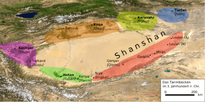
From the south to the north, the lands of the county run from the main range of the Kunlun Mountains (which forms the border with the Tibet Autonomous Region) to the middle of the Taklamakan Desert. The southernmost area of the county includes the northern side of part of the Ulugh Muztagh range (the main range of the Kunlun), and a section of the Altyn-Tagh range which runs roughly parallel to the main range of the Kunlun. Most of the county population lives in the northern foothills of the mountains, in the oases watered by snow-fed rivers.
The Qiemo River (Qarqan River) near the town of Ziemo (Qiemo) is frozen for two to three months in the winter. From the foot of the mountains to the oasis of Ziemo (Qiemo), it has a faIl of nearly 4000 feet.
Climate
| Climate data for Qiemo (1971−2000) | |||||||||||||
|---|---|---|---|---|---|---|---|---|---|---|---|---|---|
| Month | Jan | Feb | Mar | Apr | May | Jun | Jul | Aug | Sep | Oct | Nov | Dec | Year |
| Average high °C (°F) | −0.5 (31.1) |
5.3 (41.5) |
14.0 (57.2) |
23.0 (73.4) |
28.0 (82.4) |
31.1 (88) |
32.8 (91) |
32.2 (90) |
27.4 (81.3) |
19.6 (67.3) |
9.8 (49.6) |
1.3 (34.3) |
18.7 (65.6) |
| Average low °C (°F) | −13.8 (7.2) |
−9.3 (15.3) |
−1.7 (28.9) |
6.3 (43.3) |
11.7 (53.1) |
15.4 (59.7) |
17.4 (63.3) |
15.5 (59.9) |
9.6 (49.3) |
1.5 (34.7) |
−5.2 (22.6) |
−11.6 (11.1) |
3.0 (37.4) |
| Average precipitation mm (inches) | .5 (0.02) |
.4 (0.016) |
.7 (0.028) |
1.1 (0.043) |
1.7 (0.067) |
7.1 (0.28) |
7.3 (0.287) |
4.2 (0.165) |
.7 (0.028) |
.1 (0.004) |
0 (0) |
.4 (0.016) |
24.2 (0.954) |
| Average precipitation days (≥ 0.1 mm) | 1.1 | .7 | .3 | .5 | 1.0 | 2.9 | 3.5 | 1.8 | .6 | .1 | .1 | .8 | 13.4 |
| Source: Weather China | |||||||||||||
History
The modern county is based on the ancient kingdom of Qiemo (且末) mentioned in the Hanshu and the Hou Hanshu. According to the Hanshu, Qiemo/Cherchen had "230 households, 1,610 individuals and 320 persons able to bear arms."[4]
The ancient Qiemo may have been located on the east of the Cherchen (Charchan) river, across from the modern Cherchen.[5] Qiemo became part of Loulan Kingdom after it was under Chinese control during the Han dynasty and renamed Shanshan.[6] Later in 442 CE, after an attack by Juqu Anzhou, King Bilong of Shanshan fled to Qiemo together with half of his countrymen so Shanshan came to be ruled by Qiemo.[7]
The Buddhist pilgrim Xuanzang passed through this region in 644 on his return from India to China, visited a town called Nafubo (納縛波, thought to be Charklik) of Krořän (Loulan), and wrote of Ziemo (Qiemo), "A fortress exists, but not a trace of man".[8]
Marco Polo who passed through Cherchen mentioned it as a province with a town of the same name as its chief city. Its inhabitants were described as Muslims.[9]
Archaeology
Several mummies were found in Cherchen including the so-called Cherchen Man.
Transportation
The Qiemo Airport is located within this county.
Footnotes
- ↑ Hill (2015), Vol. I, p. 84.
- ↑ Mallory, J. P. & Mair, Victor H. (2000). The Tarim Mummies: Ancient China and the Mystery of the Earliest Peoples from the West. Thames & Hudson. London. p. 81. ISBN 0-500-05101-1.
- ↑ Giles (1930-1932), p. 846.
- ↑ Hill (2015), Vol. I, p. 85.
- ↑ Miller (1959), p. 24, n. 44.
- ↑ Hill (2015)
- ↑ Weishu Original text: 真君三年,鄯善王比龍避沮渠安周之難,率國人之半奔且末,後役屬鄯善。 Translation: In the third year of Zhenjun, the Loulan king Bilong, so as to avoid troubles from Juqu Anzhou, led half his countrymen and fled to Qiemo, which later controlled Shanshan.
- ↑ Da Tang Xiyu Ji Original text: 从此东行六百余里至折摩驮那故国。即涅末地也。城郭岿然人烟断绝。复此东北行千余里至纳缚波故国。即楼兰地也。
- ↑ J.M. Dent (1908), "Chapter 36: Of the Town of Lop Of the Desert in its Vicinity - And of the strange Noises heard by those who pass over the latter", The travels of Marco Polo the Venetian, pp. 99–101
References
- Giles, Lionel (1930–1932). "A Chinese Geographical Text of the Ninth Century." BSOS VI, pp. 825–846.
- Hill, John E. (2015). Through the Jade Gate - China to Rome: A Study of the Silk Routes 1st to 2nd Centuries CE. Second Edition. Vols. I-II. CreateSpace. North Charleston, South Carolina.
- Miller, Roy Andrew (1959). Accounts of Western Nations in the History of the Northern Chou Dynasty. University of California Press.

External links

- A tourism guide to Cherchen / Qiemo