Pulwama district
| Pulwama District | |
|---|---|
| District | |
 Pulwama District shown within Jammu & Kashmir state | |
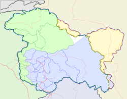 Pulwama District Location within Jammu & Kashmir | |
| Coordinates: 33°52′25″N 74°53′56″E / 33.873538°N 74.899019°ECoordinates: 33°52′25″N 74°53′56″E / 33.873538°N 74.899019°E | |
| Country |
|
| State | Jammu and Kashmir |
| Headquarters | Pulwama |
| Area | |
| • Total | 1,398 km2 (540 sq mi) |
| Elevation | 1,630 m (5,350 ft) |
| Population (2011) | |
| • Total | 570,060 |
| • Density | 410/km2 (1,100/sq mi) |
| • Literacy | 65% |
| Website | http://pulwama.nic.in |
Pulwama is a district in the Indian state of Jammu and Kashmir. District Pulwama came into being in the year 1979 in the larger interests of maintenance of law and order, closer supervision, more effective control and above all to ensure balanced development of the area. The district is centrally located in the valley of Kashmir and is a resting place for adventure tourists since it has abundant water and hospitable countryside. The district has also been nicknamed the rice bowl of Kashmir for its production of rice. Besides Pulwama is famous all over the world for Saffron cultivation which is mainly grown in the Pampore, Kakapora and Pulwama blocks. Pulwama is often called the 'Anand of Kashmir' or 'Dudha-Kul of Kashmir' on account of its high milk production. The National Highway NH1 that connects Srinagar and Jammu passes through Pulwama.
Administration
Pulwama district has seven tehsils:[1]
- Awantipora Tehsil
- Pampore Tehsil
- Pulwama Tehsil
- Tral Tehsil
- Rajpora Tehsil
- Aripal Tehsil
- Litter Tehsil
This district consists of five development blocks: Tral, Keller, Pampore, Pulwama and Kakapora.[2] Each block consists of a number of panchayats. However new tehsils were made in pulwama district in 2014.
Demographics
According to the 2011 census Pulwama district has a population of 570,060,[3] roughly equal to the nation of Solomon Islands[4] or the US state of Wyoming.[5] This gives it a ranking of 535th in India (out of a total of 640).[3] The district has a population density of 598 inhabitants per square kilometre (1,550/sq mi) .[3] Its population growth rate over the decade 2001-2011 was 29.18%.[3] Pulwama has a sex ratio of 913 females for every 1000 males,[3] lower than the national average of 940, and a literacy rate of 65%.,[3] slightly higher than the national average of 64.3%.
Schools
- Delhi Modern Public School, Pampore
- Islamic Model High School, Ratnipora Pulwama
- Govt Central High School, Pulwama
- Good Shephered Mission School, Pulwama
- Morning Star Public High School, Karimabad Pulwama
- Govt Boys M.M. Higher Secondary Institute, Pulwama
- Govt Girls Higher Secondary Institute, Pulwama
- Govt Women College, Pulwama
- Govt High School, Karimabad
- Govt Girls Middle School, Karimabad
- M.M.E.T High School, Pulwama
- MEI, Pampore
- Zikra Educational Institute, Pulwama
- Modern Public School, Achan
- Govt Degree College, Pulwama
- National Institute of Education and Training (NIET)
- New Horizons Public School, Tiken Batpora (NHPS)
- Lyceum International School
- Dolphin International School
- Holy Mission Secondary School
- Kids Kingdom Public School, Rahmoo
- Kingson English Medium School
- Islamic Model Institute Pathan, Pulwama
- Holy Blossom Public High School, Pulwama
- UMI Litter, Pulwama
- Alamdar Public High School, Koil Pulwama
- Government Higher Secondary School, Koil Pulwama
- Holy Messenger Mission School, Koil Pulwama
- Islamic Education Institute, Pahoo
- Sultania Institute of Education, Naman Kakapora
- Rasool Akram Public School, Gangoo
- Imamia Public School, Gangoo
- Govt. High school, Gangoo
- Government Higher Secondary School, Wasoora Pulwama
References
- ↑ "Archived copy". Archived from the original on 2014-05-28. Retrieved 2014-12-17.
- ↑ Statement showing the number of blocks in respect of 22 Districts of Jammu and Kashmir State including newly Created Districts Archived 2008-09-10 at the Wayback Machine. dated 2008-03-13, accessed 2008-08-30
- 1 2 3 4 5 6 "District Census 2011". Census2011.co.in. 2011. Retrieved 2011-09-30.
- ↑ US Directorate of Intelligence. "Country Comparison:Population". Retrieved 2011-10-01.
Solomon Islands 571,890 July 2011 est.
- ↑ "2010 Resident Population Data". U. S. Census Bureau. Retrieved 2011-09-30.
Wyoming 563,626
External links
Places adjacent to Pulwama district | ||||||||||
|---|---|---|---|---|---|---|---|---|---|---|
| ||||||||||