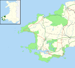
Pembrokeshire
| Pembrokeshire Sir Benfro | ||
|---|---|---|
| County | ||
| ||
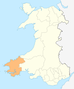 Pembrokeshire's location in Wales | ||
| Sovereign state | United Kingdom | |
| Country | Wales | |
| Ceremonial county | Dyfed | |
| Admin HQ | Haverfordwest | |
| Largest town | Haverfordwest | |
| Government | ||
| • Type | Pembrokeshire County Council | |
| • Control | Independent | |
| • MPs |
| |
| • AMs |
| |
| • MEPs | Wales | |
| Area | ||
| • Total | 610 sq mi (1,590 km2) | |
| Area rank | 5th largest Welsh county | |
| Population (2017) | ||
| • Total | 124,700 | |
| • Rank | Ranked 13th in Wales[1] | |
| • Density | 200/sq mi (77/km2) | |
| • Ethnicity | 99.2% White | |
| Geocode |
00NS (ONS) W06000009 (GSS) | |
| ISO 3166 code | GB-PEM | |
Pembrokeshire (/ˈpɛmbrʊkʃɪər/, /ˈpɛmbrʊkʃər/, or /ˈpɛmbroʊkʃɪər/; Welsh: Sir Benfro [ˈsiːr ˈbɛnvrɔ]) is a county in the southwest of Wales. It is bordered by Carmarthenshire to the east, Ceredigion to the northeast, and the sea everywhere else.
The county is home to Pembrokeshire Coast National Park, the only national park in the United Kingdom established primarily because of the coastline; the Park occupies more than a third of the area of the county and includes the Preseli Hills in the north as well as the 186-mile (299 km) Pembrokeshire Coast Path.
Industry is nowadays focused on agriculture (86 per cent of land use), oil and gas, and tourism; Pembrokeshire's beaches have won many awards. Historically mining and fishing were important activities. The county has a diverse geography with a wide range of geological features, habitats and wildlife. Its prehistory and modern history have been extensively studied, from tribal occupation, through Roman times, to Welsh, Norman and Flemish influences.
Pembrokeshire County Council's headquarters are in the county town of Haverfordwest. The council has a majority of Independent members, but the county's representatives in both the Welsh and Westminster Parliaments are Conservative. Pembrokeshire's population was 122,439 at the 2011 census, an increase of 7.2 per cent from the 2001 figure of 114,131. Ethnically, the county is 99 per cent white and, for historical reasons, Welsh is more widely spoken in the north of the county than in the south.
Settlements
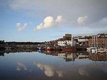
The county town is Haverfordwest. Other towns include Pembroke, Pembroke Dock, Milford Haven, Fishguard, Tenby, Narberth, Neyland and Newport. In the west of the county, St Davids is the United Kingdom's smallest city in terms of both size and population (1,841 in 2011).[2] Saundersfoot is the most populous village (more than 2,500 inhabitants)[3] in Pembrokeshire. Less than 4 per cent of the county, according to CORINE, is built-on or green urban.[4]
- See List of places in Pembrokeshire for a comprehensive list of settlements in Pembrokeshire.
Geography
Climate
| Milford Haven | ||||||||||||||||||||||||||||||||||||||||||||||||||||||||||||
|---|---|---|---|---|---|---|---|---|---|---|---|---|---|---|---|---|---|---|---|---|---|---|---|---|---|---|---|---|---|---|---|---|---|---|---|---|---|---|---|---|---|---|---|---|---|---|---|---|---|---|---|---|---|---|---|---|---|---|---|---|
| Climate chart (explanation) | ||||||||||||||||||||||||||||||||||||||||||||||||||||||||||||
| ||||||||||||||||||||||||||||||||||||||||||||||||||||||||||||
| ||||||||||||||||||||||||||||||||||||||||||||||||||||||||||||
There are three weather stations in Pembrokeshire: at Tenby, Milford Haven and Penycwm, all on the coast. Milford Haven enjoys a mild climate and Tenby shows a similar range of temperatures throughout the year,[5] while at Penycwm, on the west coast and 100m above sea level, temperatures are slightly lower.[6]
Pembrokeshire, though, featured twice in the 2016 wettest places in Wales at Whitechurch in the north of the county (1,390.4mm) and Scolton Country Park (1,284.8mm), near Haverfordwest. Orielton was the tenth driest place in Wales in 2016.[7]
The county has on average the highest coastal winter temperatures in Wales due to its proximity to the relatively warm Atlantic Ocean. Inland, average temperatures tend to fall 0.5 °C for each 100 metres increase in height.[8]
The air pollution rating of Pembrokeshire is "Good", the lowest rating.[9]
Geology
The rocks in the county were formed between 600 and 290 million years ago. More recent rock formations were eroded when sea levels rose 80 million years ago, at the end of the Cretaceous Period. Around 60 million years ago, the Pembrokeshire landmass emerged through a combination of uplift and falling sea levels; the youngest rocks, from the Carboniferous Period, contain the Pembrokeshire Coalfield.[10] The landscape was subject to considerable change as a result of ice ages; about 20,000 years ago the area was scraped clean of soil and vegetation by the ice sheet; subsequently, meltwater deepened the existing river valleys.[11][12] While Pembrokeshire is not usually a seismically active area, in August 1892 there was a series of pronounced activities (maximum intensity: 7) over a six-day period.[13]
Coastline and landscape
The Pembrokeshire coastline includes numerous bays and sandy beaches. The Pembrokeshire Coast National Park, the only park in the UK established primarily because of its coastline, occupies more than a third of the county. The park contains the Pembrokeshire Coast Path, a near-continuous 186-mile (299 km) long-distance trail from Amroth, by the Carmarthenshire border in the southeast, to St Dogmaels just down the River Teifi estuary from Cardigan, Ceredigion, in the north.[14] The National Trust owns 60 miles (97 km) of Pembrokeshire's coast.[15] Nowhere in the county is more than 10 miles (16 km) from tidal water. A large estuary and natural harbour Milford Haven cuts deep into the coast; this inlet is formed by the confluence of the Western Cleddau (which flows through Haverfordwest), the Eastern Cleddau, and rivers Cresswell[16] and Carew. Since 1975, the estuary has been bridged by the Cleddau Bridge,[17] a toll bridge carrying the A477 between Neyland and Pembroke Dock. Large bays are Newport Bay, Fishguard Bay, St Bride's Bay and western Carmarthen Bay. There are several small islands off the Pembrokeshire coast, the largest of which are Ramsey, Grassholm, Skokholm, Skomer and Caldey.[18]
There are many known shipwrecks off the Pembrokeshire coast with many more undiscovered.[19][20] A Viking wreck off The Smalls has protected status.[21] The county has six lifeboat stations, the earliest of which was established in 1822; in 2015 a quarter of all Royal National Lifeboat Institution Welsh rescues took place off the Pembrokeshire coast.[22]
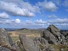
Pembrokeshire's diverse range of geological features was a key factor in the establishment of the Pembrokeshire Coast National Park and a number of sites of special scientific interest (SSSIs).[23] In the north of the county are the Preseli Hills, a wide stretch of high moorland supporting sheep farming and some forestry, with many prehistoric sites and the probable source of the bluestones used in the construction of the inner circle of Stonehenge in England.[24] The highest point is Foel Cwmcerwyn at 1,759 feet (536 m), which is also the highest point in Pembrokeshire. Elsewhere in the county most of the land (86 per cent according to CORINE) is used for farming, compared with 60 per cent for Wales as a whole.[4]
Wildlife
Pembrokeshire has a number of seasonal seabird breeding sites, including for razorbill, guillemot, puffin and Manx shearwater,[25] and rare endemic species such as the red-billed chough.[26] The county's wildlife is diverse, with marine, estuary, ancient woodland, moorland and farmland habitats all within the county.[27][28] An appeal for otter sightings in 2014 yielded more than 100 responses.[29] Seals,[30] whales, dolphins and porpoises can be seen frequently off the Pembrokeshire coast.[31]
History
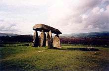
Pembrokeshire has numerous prehistoric (such as Pentre Ifan) and historic places, including a number of almost-complete and ruined castles dating from Norman times. Human habitation of the region of Pembrokeshire extends back to between 125,000 and 70,000 BCE.[32] By the late Roman Empire period between 350 and 400, an Irish tribe known as the Déisi settled in the region, with their realm known as Demetae. In the post-Roman period, the Irish Déisi merged with the local Welsh, with the regional name underlying Demetae evolving into Dyfed, which existed as an independent petty kingdom until its heiress, Elen, married Hywel Dda in 904.[32] Hywel merged Dyfed with his own maternal inheritance of Seisyllwg, forming the new realm of Deheubarth ("southern district").[32] The region suffered from devastating and relentless Viking raids during the Viking Age, with the Vikings establishing settlements and trading posts at Haverfordwest, Fishguard and Caldey Island.[32]
Dyfed, the region of Pembrokeshire, remained an integral province of Deheubarth, but this was contested by invading Normans and Flemings who arrived between 1067 and 1111.[32] The region became known as Pembroke (sometimes archaic "Penbroke"[33]), after the Norman castle built in the cantref of Penfro. In 1136, Prince Owain Gwynedd at Crug Mawr near Cardigan met and destroyed a 3,000-strong Norman/Flemish army and incorporated Deheubarth into Gwynedd.[34][35] Norman/Flemish influence never fully recovered in West Wales.[36] In 1138, the county of Pembrokeshire was named as a county palatine. Rhys ap Gruffydd, Owain Gwynedd's daughter Gwenllian's son, re-established Welsh control over much of the region and threatened to retake all of Pembrokeshire, but died in 1197.[32] After Deheubarth was split by a dynastic feud, Llywelyn the Great almost succeeded in retaking the region of Pembroke between 1216 and his death in 1240.[32]
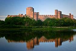
In 1457, Henry Tudor was born at Pembroke Castle. He landed an army not far from his birthplace 28 years later in 1485; he rallied support, marched to Leicestershire and defeated the larger army of Richard III at the Battle of Bosworth Field. As Henry VII of England, he founded the House of Tudor, a dynasty that ruled England until 1603.[37] The Laws in Wales Act 1535 divided the county into hundreds, which followed with some modifications the boundaries of the cantrefi, ancient jurisdictions which went back to before the Norman conquest.[38] The hundreds were (clockwise from the northeast): Cilgerran or Kilgerran, Cemais or Kemes, Dewisland or Dewsland, Roose, Castlemartin, Narberth and Dungleddy (Daugleddau). Each hundred was divided into a number of civil parishes.[39] During the First English Civil War (1642–1646) the county gave strong support to the Roundheads (Parliamentarians), in contrast to the rest of Wales, which was staunchly Royalist. In spite of this an incident in Pembrokeshire triggered the opening shots of the Second English Civil War when local units of the New Model Army mutinied. Oliver Cromwell defeated the uprising at the Siege of Pembroke in July 1648.[40] On 13 August 1649, the Cromwellian conquest of Ireland began when New Model Army forces sailed from Milford Haven.[41]
In 1720, Emmanuel Bowen[42] described Pembrokeshire as having five market towns, 45 parishes and about 4,329 houses, with an area of 420,000 acres (1,700 km2). In 1791 a petition was presented to the House of Commons concerning the poor state of many of the county's roads, pointing out that repairs could not be made compulsory by the law as it stood. The petition was referred to committee.[43] People applying for poor relief were often put to work mending roads. Workhouses were poorly documented. Under the Poor Laws, costs and provisions were kept to a minimum, but the emphasis was often on helping people to be self-employed. While the Poor Laws provided a significant means of support, there were many charitable and benefit societies.[44] After the Battle of Fishguard, the failed French invasion of 1797, 500 French prisoners were held at Golden Hill Farm, Pembroke.[45] From 1820 to 1878 one of the county's prisons, with a capacity of 86, was in the grounds of Haverfordwest Castle.[46]
In 1831, the area of the county was calculated to be 345,600 acres (1,399 km2) with a population of 81,424.[42] Throughout much of the 20th century (1911 to 1961) the population density in the county remained stable while it rose in England and Wales as a whole.[47] There was considerable military activity in Pembrokeshire in the 20th century: for example, military exercises in the Preseli Hills and a number of former military airfields.[48] Military and industrial targets in the county were subjected to bombing during World War II.[49] After the end of the war, German prisoners of war were accommodated in Pembrokeshire, the largest prison being at Haverfordwest, housing 600.[50]
Demography
Population
Pembrokeshire's population was 122,439 at the 2011 census,[51] an increase of 7.2 per cent from the 2001 figure of 114,131.[52]
Language
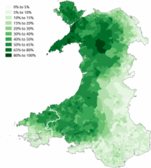
As a result of differential immigration over hundreds of years, the south of the county has fewer Welsh-speaking inhabitants (about 15 per cent) than the north (about 50 per cent). The rough line that can be drawn between the two regions, illustrated by the map, is known as the Landsker Line. The first objective, statistically-based description of this demarcation was made in the 1960s,[53] but the distinction was remarked upon as early as 1603 by George Owen of Henllys.[54]
Religion
In 1851, a religious census of Pembrokeshire showed that of 70 per cent of the population, 53 per cent were nonconformists and 17 per cent Church of England (now Church in Wales).[55] The 2001 census for Preseli Pembrokeshire constituency showed that 74 per cent were Christian and 25 per cent of no religion (or not stated), with other religions totalling less than 1 per cent. This approximates to the figures for the whole of Wales.[56]
Ethnicity
In 2001, Preseli Pembrokeshire constituency was 99 per cent white European, marginally lower than in 1991, compared with 98 per cent for the whole of Wales. 71 per cent identified their place of birth as Wales and 26 per cent as from elsewhere in the UK.[56]
Governance and politics
Under the Local Government Act 1888, an elected county council was set up to take over the functions of the Pembrokeshire Quarter Sessions. This and the administrative county of Pembrokeshire were abolished under the Local Government Act 1972, with Pembrokeshire forming two districts of the new county of Dyfed: South Pembrokeshire and Preseli – the split being made at the request of local authorities in the area.[57] In 1996, under the Local Government (Wales) Act 1994, the county of Dyfed was broken up into its constituent parts, and Pembrokeshire has been a unitary authority since then.[58] In 2017 Pembrokeshire County Council had 60 members and no political party in overall control; there were 34 independent councillors.[59] In 2009, the question of county names and Royal Mail postal addresses was raised in the Westminster parliament; it was argued that Royal Mail's continued use of the county address Dyfed was causing concern and confusion in the Pembrokeshire business community.[58] In 2018, Pembrokeshire County Council increased council tax by 12.5 per cent, the largest increase since 2004, but the county's council tax remains the lowest in Wales.[60]
The Pembrokeshire (Communities) Order 2011 established the most recent arrangement of communities (the successors to civil parishes) in the county which have their own councils; see the foot of this page for a list of communities.[61]
Since 2010, Pembrokeshire has returned two Conservative MPs to the Parliament of the United Kingdom at Westminster: Stephen Crabb for Preseli Pembrokeshire and Simon Hart for South Pembrokeshire which is represented jointly with West Carmarthenshire.[62] The corresponding Assembly Members (AMs) returned to the National Assembly for Wales in Cardiff are Paul Davies and Angela Burns respectively, both Conservatives.[63]
Transport

There are no motorways in Pembrokeshire; the nearest motorway is the M4 from London and South Wales, which terminates at the Pont Abraham services in Carmarthenshire some 46 miles (74 km) from Haverfordwest. The A40 crosses Pembrokeshire from the border with Carmarthenshire westwards to Haverfordwest, then northwards to Fishguard.[64] Some improvements have been made since the 1990s but others were still the subject of discussion in 2014.[65] The A477 from St. Clears to Pembroke Dock is 24 miles (39 km) long, of which only 2 miles (3.2 km) are dual carriageway. The Cleddau Bridge carries the A477, connecting South Pembrokeshire with North Pembrokeshire, across the Cleddau Estuary. The A478 traverses eastern Pembrokeshire from Tenby in the south to Cardigan, Ceredigion in the north, a distance of 30 miles (48 km). The A487 is the other major route, running northwest from Haverfordwest to St David's, then northeast following the coast, through Fishguard and Newport, to the boundary with Ceredigion at Cardigan.[64] Owing to length restrictions in Fishguard, some freight vehicles are not permitted to travel northeast from Fishguard but must take a longer route via Haverfordwest and Narberth.[66] The B4329 former turnpike runs from Eglwyswrw in the north to Haverfordwest across the Preseli Hills.[67]
The main towns in the county are covered by regular bus and train services, and many villages by local bus services, or community or education transport.[68]
Pembrokeshire is served by rail via the West Wales Lines from Swansea. Direct trains from Milford Haven run to Manchester Piccadilly. Branch lines terminate at Pembroke Dock, Milford Haven and Fishguard, linking with ferries to Ireland from Pembroke Dock and Fishguard.[69] Seasonal ferry services operate from Tenby to Caldey Island,[70] from St Justinians (St Davids) to Ramsey Island[71] and Grassholm Island,[72] and from Martin's Haven to Skomer Island.[73] Haverfordwest (Withybush) Airport provides general aviation services.[74]
Economy
Pembrokeshire's economy now relies heavily on tourism; agriculture, once its most important industry with associated activities such as milling, is still significant. Mining of slate and coal had largely ceased by the 20th century. Since the 1950s, petrochemical and liquid natural gas industries have developed along the Milford Haven Waterway and the county has attracted other major ventures. In 2016, the Rt. Hon. Stephen Crabb, then Welsh Secretary, commented in a government press release: "...with a buoyant local economy, Pembrokeshire is punching above its weight across the UK."[75]
Agriculture
Until the 12th century, a great extent of Pembrokeshire was virgin woodland. Clearance in the lowland south began under Anglo-Flemish colonisation and under mediaeval tenancies in other areas. Such was the extent of development that by the 16th century there was a shortage of timber in the county. Little is known about mediaeval farming methods, but much arable land was continuously cropped and only occasionally ploughed. By the 18th century, many of the centuries-old open field systems had been enclosed, and much of the land was arable or rough pasture in a ratio of about 1:3.[76]
.jpg)
Kelly's Directory of 1910 gave a snapshot of the agriculture of Pembrokeshire: 57,343 acres were cropped (almost half under oats and a quarter barley), there were 37,535 acres of grass and clover and 213,387 acres of permanent pasture (of which a third was for hay). There were 128,865 acres of mountain or heathland used for grazing, with 10,000 acres of managed or unmanaged woodland. Estimates of livestock included 17,810 horses, 92,386 cattle, 157,973 sheep and 31,673 pigs. Of 5,981 agricultural holdings, more than half were between 5 and 50 acres.[77]
Pembrokeshire had a flourishing wool industry.[78] There are still working woollen mills at Solva and Tregwynt.[79]
Pembrokeshire has good soil and benefits from the Gulf Stream, which provides a mild climate and a longer growing season than other parts of Wales.[80] Pembrokeshire's mild climate means that crops such as its new potatoes (which have protected geographical status under European law)[81] often arrive in British shops earlier in the year than produce from other parts of the UK. Other principal arable crops are oilseed rape, wheat and barley, while the main non-arable activities are dairy farming for milk and cheese, beef production and sheep farming.[78]
The county lends its name to the Pembroke Welsh Corgi, a herding dog whose lineage can be traced back to the 12th century,[82] but which in 2015 was designated as a "vulnerable" breed.[83]
Since 2006, Pembrokeshire Local Action Network for Enterprise and Development (PLANED) has provided a forum to promote an integrated approach to rural development, in which communities, public sector and voluntary partners and specialist interest groups come together to influence policy and promote projects aimed at sustainable agriculture. Sub-groups include promoting food and farming in schools and shortening supply chains.[84]
Fishing
With much of Pembrokeshire being coastline or tidal river estuaries, fishing was an important industry at least from the 16th century, with many ports and villages dependent on the industry before it declined.[85] The former large sea fishing industry around Milford Haven is now greatly reduced, although limited commercial fishing still takes place. At its peak, Milford was landing over 40,000 tons of fish a year.[85] Pembrokeshire Fish Week is a biennial event[86][87] which in 2014 attracted 31,000 visitors and generated £3 million for the local economy.[88]
Mining
Slate quarrying was a significant industry in the 19th and early 20th centuries with quarrying taking place at about 100 locations throughout the county.[89] Over 50 coal workings were in existence between the 14th and 20th centuries,[90] with the last Pembrokeshire coal mine, at Kilgetty, closing in 1950.[10]
Oil, gas and renewable energy
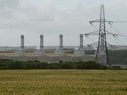
There are two oil refineries, two liquified natural gas (LNG) terminals and the 2000 MW gas-fired Pembroke Power Station (opened in 2012) at Milford Haven. The LNG terminals on the north side of the river, just outside Milford Haven were opened in 2008;[91] a 196-mile (316 km) pipeline connecting Milford Haven to Tirley in Gloucestershire was completed in 2007.[92] The two oil refineries are operated by Chevron (formerly Texaco) producing 214,000 bbl/d (34,000 m3/d) and Murco (formerly Amoco/Elf) producing 108,000 bbl/d (17,200 m3/d); the latter was sold to Puma Energy in 2015 with the intention of converting it to a storage facility.[93] At the peak, there were a total of five refineries served from around the Haven: the Esso refinery operated from 1960 to 1983, was demolished in the late 1980s and the site converted into the South Hook LNG terminal; the Gulf Refinery operated from 1968 to 1997 and the site now incorporates the Dragon LNG terminal; BP had an oil terminal at Angle Bay which served its refinery at Llandarcy and operated between 1961 and 1985.[94]
The Pembrokeshire Coast National Park Authority has identified a number of areas in which renewable energy can be, and has been, generated in the county.[95] Following several years of planning after the initial impact studies begun in 2011,[96] the first submarine turbine of three was installed in Ramsey Sound in December 2015.[97] The cumulative impact of single and multiple wind turbines is not without controversy[98] and was the subject of a comprehensive assessment in 2013.[99] In 2011 the first solar energy farm in Wales was installed at Rhosygilwen, Rhoshill with 10,000 panels in a field of 6 acres (2.4 ha).[100]
Tourism
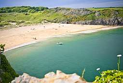
Pembrokeshire's tourism portal is Visit Pembrokeshire, run by Pembrokeshire County Council.[101] In 2015 4.3 million tourists visited the county, staying for an average of 5.24 days, spending £585 million; the tourism industry supported 11,834 jobs.[102] Many of Pembrokeshire's beaches have won awards,[103] including Poppit Sands and Newport Sands.[104] In 2018, Pembrokeshire received the most coast awards in Wales, with 56 Blue Flag, Green Coast or Seaside Awards.[105][106]
The Pembrokeshire coastline is a major draw to tourists; in 2011 National Geographic Traveller magazine voted the Pembrokeshire Coast the second best in the world and in 2015 the Pembrokeshire Coast National Park was listed among the top five parks in the world by a travel writer for the Huffington Post.[107] Countryfile Magazine readers voted the Pembrokeshire Coast the top UK holiday destination in 2018.[108] The many wrecks off the Pembrokeshire coast attract divers.[20]
The county has a number of theme and animal parks (examples are Folly Farm Adventure Park and Zoo, Manor House Wildlife Park, Blue Lagoon Water Park and Oakwood Theme Park), museums and other visitor attractions including Castell Henllys reconstructed Iron age fort, Tenby Lifeboat Station and Milford Haven's Torch Theatre.[101]
Culture
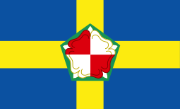
Flag
The flag of Pembrokeshire consists of a yellow cross on a blue field. In the centre of the cross is a green pentagon bearing a red and white Tudor rose. The rose is divided quarterly and counterchanged: the inner and outer roses have alternating red and white quarters.[109][110]
Physical heritage
Pembrokeshire has more than 1,600 listed buildings, ranging from mud huts to castles, and including bridges and other ancient and modern structures, under the auspices of Cadw and the County Council.[111] The National Monuments Record of Wales of the Royal Commission on the Ancient and Historical Monuments of Wales identifies nearly 6,000 sites in Pembrokeshire as worthy of study, preservation and recording, including prehistoric and modern buildings, wrecks and natural features.[112] There are 10 National Trust properties in Pembrokeshire.[113]
The arts and media
Music festivals in Pembrokeshire include those at St David's, Fishguard (folk, jazz and the International Music Festival) and Tenby (Blues Festival).[114] Milford Haven's Torch Theatre produces drama, screens films and holds exhibitions of art and crafts,[115] and there is a theatre-cinema in Fishguard (Theatr Gwaun)[116] and a cinema in Haverfordwest.[117] There are museums and art galleries in several locations in the county, including Scolton Manor, Narberth, Tenby, Milford Haven and Fishguard;[118] in Fishguard, the 100 feet (30 m) long Last Invasion Tapestry, commemorating the Battle of Fishguard in 1797, is on display.[119]
Pembrokeshire's coastal landscape and wealth of historic buildings has made it a popular location choice for film and television, including Moby Dick at Fishguard, and the final two Harry Potter films at Freshwater West. Others include (click on "show" to see the full list):
There are seven local newspapers based in Pembrokeshire: the Western Telegraph (the largest in Pembrokeshire), The Milford Mercury, Tenby Observer, Pembroke Observer, County Echo and The Pembrokeshire Herald (founded 2013[136]). The Milford Mercury (circulation 3,681) and Western Telegraph (circulation 19,582) are part of the Newsquest group. Radio Pembrokeshire, and several other West Wales radio stations, were broadcast from Narberth until 2016, when they were relocated to the Vale of Glamorgan, while retaining satellite offices at Narberth and Milford Marina.[137][138]
Sport
As the national sport of Wales, rugby union is widely played throughout the county at both town and village level. Haverfordwest RFC, founded in 1875, is a feeder club for Llanelli Scarlets. Village team Crymych RFC in 2014 plays in WRU Division One West.[139]
Triathlon event Ironman Wales has been held in Pembrokeshire since 2011, contributing £3.7 million to the local economy, and the county committed in 2017 to host the event for a further five years.[140] Ras Beca, a mixed road, fell and cross country race attracting UK-wide competitors, has been held in the Preseli Hills annually since 1977. The record of 32 minutes 5 seconds has stood since 1995.[141] Pembrokeshire Harriers athletics club was formed in 2001 by the amalgamation of Cleddau Athletic Club (established 1970) and Preseli Harriers (1989) and is based in Haverfordwest.[142]
The annual Tour of Pembrokeshire[143] road-cycling event takes place over 50, 75 or 100 miles. The 4th Tour, in April 2015, attracted 1,600 riders including Olympic gold medallist Chris Boardman[144] and there were 1,500 entrants to the 2016 event.[145] Part of Route 47 of the Celtic Trail cycle route is in Pembrokeshire. The Llys y Fran Hillclimb is an annual event run by Swansea Motor Club.[146]
Abereiddy's Blue Lagoon was the venue for a round of the Red Bull Cliff Diving World Series in 2012,[147] 2013[148] and 2016;[149] the Welsh Surfing Federation has held the Welsh National Surfing Championships at Freshwater West for several years[150] and Llys y Fran Country Park hosted the Welsh Dragonboat Championships from 2014 to 2017.[151][152]
While not at major league level, cricket is played throughout the county and many villages such as Lamphey, Creselly, Llangwm, Llechryd and Crymych field teams in minor leagues under the umbrella of the Cricket Board of Wales.[153]
Notable people

- See also Category:People from Pembrokeshire
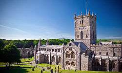
From mediaeval times, Rhys ap Gruffydd (c. 1132-1197), ruler of the kingdom of Deheubarth, was buried in St David's Cathedral.[154] and Gerald of Wales was born c. 1146 at Manorbier Castle.[155] Henry Tudor (later Henry VII) was born in 1457 at Pembroke Castle.[156]
In later military history, Jemima Nicholas, heroine of the so-called "last invasion of Britain" in 1797, was from Fishguard,[157] Lieutenant General Sir Thomas Picton GCB, born in Haverfordwest, was killed at the Battle of Waterloo in 1815[158] and Private Thomas Collins was the only Pembrokeshire man that fought in the Battle of Rorke's Drift in 1879.[159]
In the arts, siblings Gwen and Augustus John were both born in Pembrokeshire,[160] as was the novelist Sarah Waters;[161] singer Connie Fisher grew up in Pembrokeshire.[162]
Stephen Crabb, former Secretary of State for Work and Pensions and Secretary of State for Wales, was brought up in Pembrokeshire and represents the county as one of its two Members of Parliament.[163]
| Wikimedia Commons has media related to People of Pembrokeshire. |
Education and health
A comprehensive review of education in Pembrokeshire was carried out in 2014 with a number of options for discussion in 2015.[164] In 2018 there were 58 primary schools, 8 secondary schools (two are age 3-16) and one special school in Pembrokeshire, providing education for more than 18,300 pupils. These include 15 Welsh medium primary schools in the county, three dual stream schools and two transition schools; four primary schools are classified as English Welsh schools (English medium schools with significant use of Welsh). In 2017/18, 22 per cent of seven-year-old pupils were educated through the medium of Welsh. This figure is expected to rise to 25 per cent by 2019/20.[165]
The Preseli Branch of the University of the Third Age (U3A) provides musical appreciation as a subject.[166]
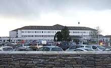
Health services in the county are provided by Hywel Dda Local Health Board which also provides for Ceredigion and Carmarthenshire. The county's principal hospital is Withybush General Hospital in Haverfordwest,[167] and there are local hospitals in Tenby[168] and Pembroke Dock.[169]
See also
References
- ↑ "Population Estimates for UK, England and Wales, Scotland and Northern Ireland, Mid-2017". Office for National Statistics. 28 June 2018. Retrieved 28 June 2018.
- ↑ "Office for National Statistics 2011 – census – St David's and the Cathedral Close C".
- ↑ "Ward and community population 2011". Retrieved 21 April 2011.
- 1 2 Mark Easton (9 November 2017). "How much of your area is built on?". BBC News. Retrieved 9 November 2017.
- ↑ "Tenby climate information". Retrieved 4 December 2017.
- ↑ "Penycwm climate information". Retrieved 4 December 2017.
- ↑ Katie Sands (31 January 2017). "The wettest place in Wales in 2016 has been named". Wales Online. Retrieved 6 December 2017.
- ↑ "Met Office: Wales: Climate". Retrieved 6 December 2017.
- ↑ "Pollution hotspots revealed: Check your area". BBC News. 10 January 2018. Retrieved 10 January 2018.
- 1 2 "Pembrokeshire Virtual Museum - Coal Mining". Archived from the original on 24 September 2015. Retrieved 29 April 2014.
- ↑ "Pembrokeshire Virtual Museum: Geology". Archived from the original on 6 April 2015. Retrieved 29 March 2015.
- ↑ Howells, Sid. "Geological History of Pembrokeshire". pembrokeshireonline.co.uk. Retrieved 21 June 2016.
- ↑ Davison, C. (2009) [1924]. A History of British Earthquakes. Cambridge University Press. p. 184. ISBN 978-0-521-14099-7. Retrieved 29 March 2015.
- ↑ "National Trails: Pembrokeshire Coast Path". Retrieved 3 February 2018.
- ↑ "£40K cash boost for Pembrokeshire conservation project". BBC News. 27 January 2018. Retrieved 28 January 2018.
- ↑ "Pembroke Coast National Park - River Cresswell". Retrieved 21 June 2014.
- ↑ "Cleddau Bridge". Hansard. 8 December 1994.
- ↑ "Pembrokeshire Coast National Park: Pembrokeshire's Islands". Retrieved 29 January 2018.
- ↑ "Pembrokeshire has 'thousands' of undiscovered wrecks - diver". BBC. 26 October 2014. Retrieved 6 December 2014.
- 1 2 "Dive Pembrokeshire". Retrieved 4 May 2015.
- ↑ Will Hayward (6 January 2018). "The hidden wrecks of Wales that you never knew were there". Wales online. Retrieved 11 January 2018.
- ↑ "Quarter of all 2015 Welsh lifeboat rescues were off Pembrokeshire". Milford & West Wales Mercury. 27 January 2016. Retrieved 27 January 2016.
- ↑ "Pembrokeshire Coast National Park - Pembrokeshire's geology". Retrieved 29 March 2015.
- ↑ "Dyfed Archaeological Trust - Mynydd Preseli". Retrieved 28 November 2016.
- ↑ "Pembrokeshire Coast National Park: Seasonal seabirds". Retrieved 3 February 2018.
- ↑ Madge, Steve; Burn, Hilary (1994). Crows and jays: a guide to the crows, jays and magpies of the world. A&C Black. pp. 133–5. ISBN 0-7136-3999-7.
- ↑ "The Wildlife Trust of South and West Wales". Retrieved 25 January 2015.
- ↑ "Top 10 wildlife spots in Pembrokeshire - in pictures". The Guardian. 10 July 2012. Retrieved 25 January 2015.
- ↑ "100 otters spotted on Pembrokeshire coast after appeal". BBC News. 17 June 2014. Retrieved 1 June 2016.
- ↑ "Pembrokeshire County Council: Visit Pembrokeshire: Seal watching in Pembrokeshire". Retrieved 1 June 2016.
- ↑ "Pembrokeshire County Council: Visit Pembrokeshire: Whale and Dolphin watching". Retrieved 1 June 2016.
- 1 2 3 4 5 6 7 Davies, John, A History of Wales, Penguin, 1994, foundations of pgs 17,19, 43, Migration of the Desi into Demetia, page 52 Demetia 17, 30, 34, ruling house of 52, 72, 85, 87, and the Vikings pages 85, relations with Alfred of Wessex, page 85, and the Vikings/Northmen page 98, and the Normans 106, 112, 114
- ↑ Pughe, William Owen (1799). Cambrian Register. E & T Williams, Strand. pp. 53–230. Retrieved 7 May 2015.
- ↑ Lloyd, J. E. (2004). A History of Wales: From the Norman Invasion to the Edwardian Conquest. Barnes & Noble. pp. 80–85.
- ↑ Davies, John (1994). A History of Wales. Penguin. p. 124.
- ↑ Warner, Philip, Famous Welsh Battles, pg 79, 1997, Barnes and Noble, INC.
- ↑ Davies, Norman. The Isles – A History. pp. 337–379.
- ↑ "Laws in Wales Act 1535 (repealed 21.12.1993) (c.26)". The UK Statute Law Database website. Office of Public Sector Information. 2010. Retrieved 28 November 2016.
- ↑ "GENUKI: Pembrokeshire Hundreds and Parishes". Retrieved 16 October 2016.
- ↑ Royle, Trevor. Civil War: The War of the Three Kingdoms 1638–1660. Abacus, 2005. p. 437–38
- ↑ "BCW Project: 1649 timeline". Retrieved 28 November 2016.
- 1 2 "GENUKI: Pembrokeshire". Retrieved 28 January 2018.
- ↑ Journals of the House of Commons. 46. HMSO. 1803. p. 178. Retrieved 17 May 2015.
- ↑ "Pambrokeshire Historical Society: Aspects of the Old Poor Law". Retrieved 13 February 2018.
- ↑ "Coflein: Golden Hill Prison". Retrieved 13 February 2018.
- ↑ "Pembrokeshire council to sell old Haverfordwest prison". BBC News. 9 July 2010. Retrieved 13 February 2018.
- ↑ "A Vision of Britain through Time: Pembrokeshire population density". Retrieved 1 February 2018.
- ↑ "A Guide to the Military Heritage of Pembrokeshire". Retrieved 22 June 2014.
- ↑ "Pembrokeshire Virtual Museum - Air Raids". Archived from the original on 12 December 2014. Retrieved 12 December 2014.
- ↑ "German Prisoners of War in Pembrokeshire". Western Telegraph. Retrieved 13 February 2018.
- ↑ "UK Census data". Retrieved 16 December 2017.
- ↑ "2011 Census". Retrieved 8 December 2013.
- ↑ John, Brian S, "The Linguistic Significance of the Pembrokeshire Landsker" in The Pembrokeshire Historian, 4, 1972 pp 7–29.
- ↑ Owen, George, The Description of Pembrokeshire Dillwyn Miles (Ed) (Gomer Press, Llandysul 1994) ISBN 1-85902-120-4.
- ↑ "Pembrokeshire Historical Society: THE 1851 RELIGIOUS CENSUS IN PEMBROKESHIRE". Retrieved 19 December 2017.
- 1 2 "2001 Census of Population for Preseli Pembrokeshire" (PDF). Retrieved 19 December 2017.
- ↑ Wood, Bruce. The Process of Local Government Reform: 1966–1974. 1976.
- 1 2 Westminster Hall Debate. Hansard. 23 June 2009. Retrieved 5 February 2017.
- ↑ "Pembrokeshire County Council: Your Councillors". Retrieved 18 December 2017.
- ↑ "Monthly bin collection: Conwy council warns of tax hike". BBC News. 26 September 2018. Retrieved 26 September 2018.
- ↑ "The Pembrokeshire (Communities) Order 2011". Retrieved 18 December 2017.
- ↑ "All change in Carmarthen and Pembrokeshire". BBC News. Retrieved 18 December 2017.
- ↑ "Assembly Election 2016: The full list of Welsh AMs". WalesOnline. 6 May 2016. Retrieved 18 December 2017.
- 1 2 "Bing maps: Pembrokeshire". Retrieved 31 January 2018.
- ↑ "Dualling work to the A40 in Pembrokeshire could be moving a step closer, says AM Paul Davies". Wales Online. 22 October 2014. Retrieved 25 February 2015.
- ↑ "Lower Town, Fishguard, still blighted by lorry chaos". Western Telegraph. 27 June 2010. Retrieved 31 January 2018.
- ↑ Ordnance Survey: Landranger Edition, Nos. 145, 157, 158 (2007)
- ↑ "Pembrokeshire County Council: Public transport". Retrieved 24 March 2016.
- ↑ "Arriva Trains Wales: Network Map". Retrieved 1 February 2018.
- ↑ "Tenby Guide: Caldey Island". Retrieved 1 February 2018.
- ↑ "Pembrokeshire County Council: Visit Pembrokeshire: Ramsey Island". Retrieved 1 February 2018.
- ↑ "Pembrokeshire County Council: Visit Pembrokeshire: Grassholm Island". Retrieved 1 February 2018.
- ↑ "Pembrokeshire County Council: Visit Pembrokeshire: Skomer Island". Retrieved 1 February 2018.
- ↑ "NATS Aeronautical Information Service". Retrieved 16 October 2016.
- ↑ "Office of the Sectretary of State for Wales: Stephen Crabb: "Pembrokeshire is punching above its weight with a strong local economy"". Retrieved 17 February 2018.
- ↑ "GENUKI: Pembrokeshire Farming c1580-1620". Archived from the original on 13 December 2014. Retrieved 12 December 2014.
- ↑ "GENUKI: Agricultural Statistics 1908". Retrieved 12 December 2014.
- 1 2 "Pembrokeshire Virtual Museum - Types of Farming". Archived from the original on 24 September 2015. Retrieved 12 December 2014.
- ↑ "Welsh Mills Society". Retrieved 16 May 2015.
- ↑ Davies, Gilli: A Taste of Wales, page 142. London: Pavilion Books Limited, 1995. ISBN 1-85793-293-5
- ↑ "Pembrokeshire Early Potato gets protected European status". BBC. 4 December 2013. Retrieved 12 December 2014.
- ↑ Wheeler, Jill C. (2010). Welsh Corgis. ABDO. p. 6. ISBN 1-61613-641-3.
- ↑ "The Queen's Corgis designated a 'vulnerable' breed". The Telegraph. 8 February 2015. Retrieved 16 May 2015.
- ↑ "PLANED: Pembrokeshire sustainable agriculture network". Retrieved 28 November 2017.
- 1 2 "Pembrokeshire Virtual Museum - The Fishing Industry". Archived from the original on 24 September 2015. Retrieved 11 October 2014.
- ↑ "Pembrokeshire Fish Week". Retrieved 11 October 2014.
- ↑ "Pembrokeshire Fish Week". Wales Online. 3 June 2014. Retrieved 11 October 2014.
- ↑ "Why fish are proving to be Pembrokeshire's newest tourism asset". Wales Online. 28 November 2014. Retrieved 3 December 2014.
- ↑ Tucker, G & M (1983). The old slate industry of Pembrokeshire and other parts of South Wales. National Library of Wales journal, Vol.XXIII/2.
- ↑ "GENUKI: The Coal Industry in Pembrokeshire". Retrieved 12 December 2014.
- ↑ "Timeline: LNG plants in Wales". BBC News. 19 March 2009. Retrieved 1 February 2018.
- ↑ "Controversial gas pipe completed". BBC News. 27 November 2007. Retrieved 15 February 2009.
- ↑ "Puma Energy buys Murco Milford Haven oil refinery site". BBC News. 13 March 2015. Retrieved 1 February 2018.
- ↑ "Angle Bay BP oil terminal and pumping station, Popton, Milford Haven". Coflein. Royal Commission on the Ancient and Historical Monuments of Wales. 14 April 2010. Retrieved 1 August 2012.
- ↑ "Pembrokeshire Coast National Park: Renewable energy sources". Retrieved 14 December 2015.
- ↑ "Pembrokeshire tidal power impact studied". BBC. 8 May 2011. Retrieved 14 December 2015.
- ↑ "Giant tidal turbine placed on seabed off Pembrokeshire". BBC. 14 December 2015. Retrieved 14 December 2015.
- ↑ "Wind turbine plans in Pembrokeshire continue to generate debate". Western Telegraph. 10 April 2013. Retrieved 14 December 2015.
- ↑ Pembrokeshire and Carmarthenshire: Cumulative Impact of Wind Turbines on Landscape and Visual Amenity guidance. April 2013.
- ↑ "Wales' first solar park powers up in Pembrokeshire". BBC. 8 July 2011. Retrieved 27 April 2015.
- 1 2 "Visit Pembrokeshire". Retrieved 10 February 2018.
- ↑ "£585 million Pembrokeshire tourism boost". Western Telegraph. 23 July 2011. Retrieved 10 February 2018.
- ↑ "Visit Pembrokeshire: Pembrokeshire's award winning beaches, 2017". Retrieved 3 February 2018.
- ↑ "Ceredigion and Pembrokeshire beaches get top award". Tivyside Advertiser. 17 May 2018. Retrieved 17 May 2018.
- ↑ "Top awards for beautiful Pembrokeshire beaches". Western Telegraph. 17 May 2018. Retrieved 17 May 2018.
- ↑ "Wales beaches praised in Keep Wales Tidy Blue Flag awards". BBC News. 17 May 2018. Retrieved 18 May 2018.
- ↑ "Pembrokeshire Coast National Park named among the five best in the world". Western Telegraph. 22 May 2015. Retrieved 26 May 2015.
- ↑ "Visit Pembrokeshire: BBC Countryfile Magazine Awards 2018". Retrieved 26 March 2018.
- ↑ "Flag Institute: Pembrokeshire". Retrieved 29 January 2018.
- ↑ "CRWFlags.com". Retrieved 6 July 2016.
- ↑ "Pembrokeshire County Council: Listed Buildings". Retrieved 18 February 2018.
- ↑ "Royal Commission on Ancient and Historical Monuments of Wales: Pembrokeshire". Retrieved 18 February 2018.
- ↑ "National Trust: Pembrokeshire". Retrieved 27 February 2018.
- ↑ "Visit Pembrokeshire: Music in Pembrokeshire". Retrieved 7 February 2018.
- ↑ "Visit Pembrokeshire: The Torch Theatre". Retrieved 7 February 2018.
- ↑ "Visit Pembrokeshire: Theatr Gwaun". Retrieved 7 February 2018.
- ↑ "Secret history of Pembrokeshire's forgotten cinemas rediscovered". Western Telegraph. 14 January 2018. Retrieved 7 February 2018.
- ↑ "Visit Pembrokeshire: Museums and art galleries". Retrieved 7 February 2018.
- ↑ "Visit Pembrokeshire: Last Invasion Tapestry". Retrieved 8 February 2018.
- ↑ "The Thief of Bagdad". Retrieved 30 June 2016.
- 1 2 3 4 5 "Wales hosts Hollywood blockbusters". Retrieved 12 May 2016.
- ↑ "Fury at Smuggler's Bay". Retrieved 30 June 2016.
- ↑ "Jaberwocky". Retrieved 30 June 2016.
- ↑ "Dragonworld". Retrieved 30 June 2016.
- ↑ "Basil". Retrieved 30 June 2016.
- ↑ "Baltic Storm". Retrieved 30 June 2016.
- ↑ "I Capture the Castle". Retrieved 30 June 2016.
- ↑ Youngman, Angela (15 November 2011). In the Footsteps of Robin Hood. Collca. p. 34. ISBN 978-1-908795-00-7.
- ↑ "Third Star". Retrieved 30 June 2016.
- ↑ Miller, C. D. (8 June 2012). Harry Potter Places: Snitch-Seeking in Southern England and Wales. First Edition Design Pub. p. 52. ISBN 978-1-937520-98-4.
- ↑ McDowell, Martin (21 September 2011). "Filming Snow White and the Huntsman at Marloes Sands". Archived from the original on 28 January 2012. Retrieved 10 May 2016.
- ↑ "Solva taken over for Under Milkwood filming". BBC News. 23 June 2014. Retrieved 10 May 2016.
- ↑ Hannah Jones (27 March 2015). "Bad Education takes over Pembroke Castle for film version of the hit show". Wales online. Retrieved 10 May 2016.
- ↑ "Premiere for new film Their Finest shot in Wales". BBC News. 18 April 2017. Retrieved 18 April 2017.
- ↑ Bruce Sinclair (10 May 2016). "Me Before You movie release will see Pembroke on the silver screen". Western Telegraph. Retrieved 10 May 2016.
- ↑ "Third new local newspaper launched in Wales". BBC. 5 July 2013. Retrieved 7 November 2014.
- ↑ "Jobs at risk as Nation Broadcasting plans to relocate stations". BBC News. 14 September 2016. Retrieved 18 February 2018.
- ↑ "Radio Pembrokeshire: Public file" (PDF). Retrieved 18 February 2018.
- ↑ "SWALEC League: 1 West". Retrieved 25 April 2014.
- ↑ "New five-year Ironman Wales deal confirmed for Tenby". BBC News. 7 September 2017. Retrieved 7 September 2017.
- ↑ "All set for Beca event". Tivyside Advertiser. 13 August 2014. Retrieved 14 August 2014.
- ↑ "Pembrokeshire Harriers - Club history". Retrieved 14 August 2014.
- ↑ "Tour of Pembrokeshire". Retrieved 30 April 2015.
- ↑ "Gold medallist to ride Tour of Pembrokeshire". Pembrokeshire Herald. 22 April 2015. Retrieved 30 April 2015.
- ↑ Jon Coles (20 May 2016). "Cycling tour a resounding success!". Pembrokeshire Herald. Retrieved 20 May 2016.
- ↑ "Llys-Y-Fran Hillclimb Guide". Retrieved 29 June 2016.
- ↑ Aaron, Martin (8 September 2012). "Red Bull Cliff Diving World Series' Pembrokeshire UK debut" – via www.bbc.co.uk.
- ↑ "World Series cliff divers brave Pembrokeshire cliffs". 13 September 2013 – via www.bbc.co.uk.
- ↑ Ceri Coleman-Phillips (10 September 2016). "Cliff diving: 'It's always a jump into the unknown'". BBC News. Retrieved 11 September 2016.
- ↑ "Welsh Surf News". Retrieved 30 March 2015.
- ↑ "Country Park welcomes Welsh Dragonboat Championships". BBC News. 29 May 2016. Retrieved 29 May 2016.
- ↑ "Hear the dragons roar at rowing championship tomorrow". Milford Mercury. 27 May 2017. Retrieved 27 May 2017.
- ↑ "Cricket Wales". Retrieved 29 January 2018.
- ↑ Rhys ap Gruffydd. Dictionary of Welsh Biography. National Library of Wales. Retrieved 11 June 2018.
- ↑ MacCaffrey, James. "Giraldus Cambrensis." The Catholic Encyclopedia Vol. 6. New York: Robert Appleton Company, 1909. 20 Jul. 2015
- ↑ Caroline Rogers and Roger Turvey, Henry VII, London: Hodder Murray, 2005
- ↑ "Invasion heroine's records find". BBC News. 4 April 2006. Retrieved 10 May 2017.
- ↑ "National library of Wales: Biographies". Retrieved 31 January 2018.
- ↑ "Plan to honour Rorke's Drift hero". BBC News. Retrieved 2016-09-16.
- ↑ Justin Mintle (2002). "Makers of Modern Culture". Psychology Press. p. 251. ISBN 9780415265836. Retrieved 29 January 2018.
- ↑ Allardice, Lisa (1 June 2006). "Uncharted Waters". The Guardian. UK. Retrieved 30 January 2018.
- ↑ "Profile of Connie". Maria. pembrokeshiretv.com. 16 September 2006. Archived from the original on 13 March 2007.
- ↑ "From council house to cabinet: the unlikely childhood of Stephen Crabb". Daily Telegraph. 26 March 2016.
- ↑ "Closure of Sir Thomas Picton, Tasker Milward, Ysgol Dewi Sant and Ysgol Bro Gwaun Schools planned in huge shake-up". Western Telegraph. 22 January 2015. Retrieved 25 January 2015.
- ↑ "Pembrokeshire County Council: Pembrokeshire Schools". Retrieved 4 September 2018. Note: some information requires downloading pdf file
- ↑ "Education: the age of uncertainty". The Independent. 16 June 2011. Retrieved 25 January 2015.
- ↑ "Withybush Hospital, Haverfordwest". Retrieved 29 November 2016.
- ↑ "Tenby Cottage Hospital" (PDF). Retrieved 29 November 2016.
- ↑ "South Pembrokeshire Hospital". Retrieved 29 November 2016.
Further reading
- Dillon, Myles, The Irish settlements in Wales, Celtica 12, 1977, pp. 1–11
- Downes, John, Folds, faults and fossils: Exploring geology in Pembrokeshire. Llygad Gwalch Cyf, 2011. ISBN 978-1-84524-172-8
- Fenton, Richard, A historical tour through Pembrokeshire. Longman, Hurst, Rees, Orme &Co, 1811
- Fudge, Pam, Through the lens of Harry Squibbs: Pembrokeshire. Amberley Publishing, 2014. ISBN 978-1-4456-3441-8. (Early 1900s photographs)
- James, J. Ivor, Molleston Baptist Church-Reflections on the Founders' Tercentenary, V.G. Lodwick & Sons Ltd., Carmarthen, 1968
- John, Brian, The geology of Pembrokeshire. Abercastle Publications, 1998. ISBN 978-1-872887-20-3
- Lloyd, Thomas; Orbach, Julian and Scourfield, Robert, Pembrokeshire - The buildings of Wales, Yale University Press, 2004. ISBN 978-0-300-10178-2
- Owen, George of Henllys, A History of Pembrokeshire. Reprinted in Cambrian Register, Volume 2, 1799. 1603.
External links
| Wikivoyage has a travel guide for Pembrokeshire. |
| Wikimedia Commons has media related to Pembrokeshire. |
- Historical information about Pembrokeshire on GENUKI
- Pembrokeshire County Council
- Visit Pembrokeshire (official council tourism website)
- Pembrokeshire Cultural Services (archives, libraries, museums)
- Pembrokeshire County Council's Tourism Industry Website
Transport in Pembrokeshire | ||
|---|---|---|
| Roads | 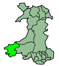 | |
| Cycling | ||
| Railway lines | ||
| Railway stations | ||
| Air | ||
| Sea | ||