Bridgend County Borough
| Bridgend County Borough Bwrdeistref Sirol Pen-y-bont ar Ogwr | |
|---|---|
| county borough | |
 | |
| Admin HQ | Bridgend |
| Largest town | Bridgend |
| Government | |
| • Type |
 Bridgend County Borough Council http://www.bridgend.gov.uk/ |
| • Control | Labour |
| • MPs | |
| • AMs |
|
| • MEPs | Wales |
| Area | |
| • Total | 246 km2 (95 sq mi) |
| Area rank | Ranked 17th |
| Population (2017) | |
| • Total | 144,300 |
| • Rank | Ranked 8th |
| • Density | 575/km2 (1,490/sq mi) |
| • Density rank | Ranked 7th |
| • Ethnicity | 98.4% White |
| Welsh language | |
| • Rank | Ranked 14th |
| • Any skills | 19.9% |
| Geocode |
00PB (ONS) W06000013 (GSS) |
| ISO 3166 code | GB-BGE |
 | ||||
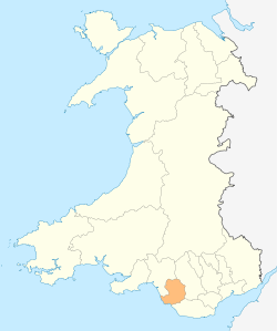
Bridgend County Borough (shaded brown) is one of the western unitary authorities of the South Wales valleys.
| ||||
Bridgend (Welsh: Pen-y-bont ar Ogwr) is a county borough in southern Wales, UK. The county borough has a total population of 139,200 people, and contains the settlements of Bridgend, after which it is named, Maesteg. Its members of the National Assembly for Wales is Carwyn Jones AM, the First Minister of Wales and Huw Irranca-Davies AM representing the Ogmore Constituency, and its Members of Parliament are Madeleine Moon and Chris Elmore.
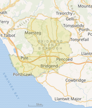
The county borough lies at the geographical heart of south Wales. Its land area of 285 square kilometres stretches 20 km from east to west and occupies the Llynfi, Garw and Ogmore valleys. The largest town is Bridgend (pop: 39,773), followed by Maesteg (pop: 20,700) and seaside resort of Porthcawl (pop: 19,238). It is situated on the Ogmore River and its tributaries, although the Ewenny and Ogwr Fach rivers are considered the border with the Vale of Glamorgan for much of their length.
It was formed on 1 April 1996 under the Local Government (Wales) Act 1994. It includes all of the former Ogwr borough apart from the communities of Wick, St Bride's Major and Ewenny, which went to Vale of Glamorgan. Bridgend County Borough was divided into 20 communities: Brackla, Bridgend, Cefn Cribwr, Coity Higher, Coychurch Higher, Coychurch Lower, Cornelly, Garw Valley, Laleston, Llangynwyd Lower, Llangynwyd Middle, Maesteg, Merthyr Mawr, Newcastle Higher, Ogmore Valley, Pencoed, Porthcawl, Pyle, St Bride's Minor and Ynysawdre. The communities of Brackla, Bridgend and Coychurch Lower make up the town of Bridgend.
Government
The region is governed by Bridgend County Borough Council, a Principal council. It is currently in the control of the Labour party with 39 seats out of 54.
Schools
Parks and green spaces
Bryngarw Country Park is the largest (113 acres) Country Park in the borough. It offers many amenity based areas including an adventure play area, barbecue and picnic areas, car park, cafe, visitor centre and toilets; as well as a patchwork of woodland, grassland and freshwater habitats. Bryngarw Country Park is a Grade II listed Historic Park and Garden and has been designated a 'Green Flag' Park since 2010. The Oriental Garden in the park has been noted as a 'Visit Wales Sustainable Tourism, Historic Gardens Centre of Excellence’ by the 'One Historic Garden, Centre of Excellence'.[1]
Kenfig National Nature Reserve Glamorgan’s largest natural lake, Kenfig Pool, is set on the edge of this area, with views from Sker beach across Swansea Bay to the Gower. It is one of the finest Wildlife habitats in Wales, and one of the last remnants of a huge dune system that once stretched along the coast of Southern Wales from the River Ogmore to the Gower peninsula. The reserve is home to unique wild orchids, as well as insects and wildlife. Kenfig is one of the most important sites in Britain for nature conservation.[2]
Parc Slip Nature Reserve is an environment of wetlands, woodlands and meadows at the Parc Slip Nature Park where there is a wealth of wildlife, whatever the season. After a century of coal mining on the site, the Wildlife Trust began to manage the land for nature in the late 1980s. Varied habitats have since been created and the park supports an increasing diversity of wildlife.[3][4]
Notable people
- Category:People from Bridgend
See also
References
- ↑ "Welcome to Bryngarw House, Brynmenyn, Bridgend". Bryngarwhouse.co.uk. Retrieved 6 August 2011.
- ↑ "Country Parks". Retrieved 8 September 2012.
- ↑ "Country Parks". Archived from the original on 3 September 2012. Retrieved 8 September 2012.
- ↑ "Country Parks". Retrieved 6 August 2011.
External links
- Bridgend County Borough at Curlie (based on DMOZ)
- Bridgend County Borough Council
- Bridgend Association of Voluntary Organisations
| Communities | | |
|---|---|---|
| Towns and villages |
| |
| Castles | ||
| Rivers | ||
| Topics | ||