List of national parks of England and Wales

Within England and Wales there are thirteen areas known as national parks, each administered by its own national park authority, a special purpose local authority, the role of which as set out in the Environment Act 1995 is: to conserve and enhance the natural beauty, wildlife and cultural heritage of the National Parks. and to promote opportunities for the understanding and enjoyment of the special qualities of the National Parks by the public. The national park authority for each park addresses these aims in partnership with other organisations, such as the National Trust. In cases where there may be conflict between the two purposes of designation, the first must take precedence under the Sandford Principle. The national park authorities also have a duty to foster the economic and social wellbeing of communities in pursuit of these purposes.[1]
Legal designation
National parks are designated under the National Parks and Access to the Countryside Act 1949 and must be confirmed by the Secretary of State for Environment, Food and Rural Affairs. The 1949 Act came about after a prolonged campaign for public access to the countryside in the United Kingdom with its roots in the Industrial Revolution. The first 'freedom to roam' bill was introduced to Parliament in 1884 by James Bryce but it was not until 1931 that a government inquiry recommended the creation of a 'National Park Authority' to select areas for designation as national parks. Despite the recommendation and continued lobbying and demonstrations of public discontent, such as the 1932 Kinder Scout mass trespass in the Peak District, nothing further was done until a 1945 white paper on national parks was produced as part of the Labour Party's planned post-war reconstruction, leading in 1949 to the passing of the National Parks and Access to the Countryside Act.[2]
In England and Wales, as in Scotland, designation as a national park means that the area has been identified as being of importance to the national heritage and as such is worthy of special protection and attention. Unlike the model adopted in many other countries, such as the USA and Germany, this does not mean the area is owned by the state. National parks may include substantial settlements and human land uses which are often integral parts of the landscape, and within a national park there are many landowners including public bodies and private individuals.[3]
Origins and growth
The first national park, and site of the Kinder Scout trespass, the Peak District, was designated in April 1951 under the Clement Attlee led Labour administration, eight months before the end of King George VI's reign. This was followed in the same year by the designations of three more national parks; the Lake District, Snowdonia and Dartmoor. By the end of the decade the national park family had increased to ten with the Pembrokeshire Coast, North York Moors, Yorkshire Dales, Exmoor, Northumberland and Brecon Beacons national parks all being designated.[2] The Norfolk and Suffolk Broads, the eleventh member of the national park family, was designated through its own Act of Parliament in 1988 gaining status equivalent to that of a national park. Separate legislation was passed in Scotland, namely the National Parks (Scotland) Act 2000, and from this two Scottish national parks, the Cairngorms and Loch Lomond and The Trossachs, were created. Of the original twelve proposed English and Welsh national parks, two remained undesignated going into the new millennium - the Cambrian Mountains and Cornish Coast. The New Forest became a national park in 2005 and the South Downs was formally designated on 31 March 2010. All fifteen United Kingdom national parks are represented by the Association of National Park Authorities.
Of the ten national parks in England, five are in the northern counties, two in the southwest counties, one in the east, and the most recent two designations in the south. In total, the national parks touch only sixteen English counties and cover 9.3% of England,[4] with no national park in the central counties. The three national parks of Wales by contrast occupy 19.9% of the land.[4] The Lake District National Park at 2,292 square kilometres (885 sq mi) is the largest National Park in England and second largest in the United Kingdom after Scotland's Cairngorms National Park. Snowdonia National Park, at 2,142 square kilometres (827 sq mi), is Wales' largest national park and the third largest in the United Kingdom. The smallest national park in England and Wales, and in the United Kingdom, is The Broads at 303 square kilometres (117 sq mi). The total area of the national parks in England and Wales is approximately 16,267 square kilometres (6,281 sq mi), for an average of 1,251 square kilometres but a median of 1,344 square kilometres.[4] In the United Kingdom the total increases to 22,660 square kilometres (average 1511 km2).[4] The most-visited national park is the Lake District, with 15.8 million visitors in 2009, although by visitor days the South Downs at 39 million compares to 23.1 million for the Lake District.[4]
Other designated landscapes
The United Kingdom has a number of other designated landscape areas besides its national parks. Most similar to the parks are Areas of Outstanding Natural Beauty which differ in part because of their more limited opportunities for extensive outdoor recreation.[5] Dartmoor, the Lake District, North York Moors and the Yorkshire Dales all abut AONBs and in addition the coasts of Exmoor and the North York Moors coincide with heritage coasts.[6] All the Parks contain in varying numbers Sites of Special Scientific Interest and national nature reserves. A part of the Brecon Beacons National Park is also designated a European Geopark. Of the various World Heritage Sites in England and Wales, none are national parks in themselves though a part of the Blaenavon Industrial Landscape World Heritage Site falls within the Brecon Beacons National Park.[7]
National parks
| Name | Photo | Country / County |
Date formed[8] | Area | Description |
|---|---|---|---|---|---|
| Peak District | 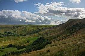 |
England Derbyshire Cheshire Greater Manchester Staffordshire South Yorkshire West Yorkshire 53°21′N 1°50′W / 53.350°N 1.833°W |
April 17, 1951 | 1,438 square kilometres (555.2 sq mi) | The central location of this park provides for the coincidence of the northern limit of many lowland species, such as the stemless thistle and nuthatch and the southern extent of many northern upland species, such as the mountain hare and globe flower. The Carboniferous Limestone of the White Peak in its southern and central areas, gives rise to peaks formed by harder reef limestone and dales rich in wildlife (typically over fifty species of wildflower and herb per square metre) gouged out by meltwater from the Ice Age. In the north, east and west is the Dark Peak where the rocks are shale, sandstone and gritstone and where layers of peat have given rise to bleak moorland landscapes.[9] |
| Lake District | 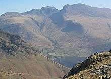 |
England Cumbria 54°30′N 3°10′W / 54.500°N 3.167°W |
May 9, 1951 | 2,292 square kilometres (884.9 sq mi) | England's largest national park has geology providing a dramatic record of nearly 500 million years, with evidence of colliding continents, deep oceans, tropical seas, and kilometre-thick ice sheets. The area has the largest and deepest lakes and highest peaks in England. This landscape is overlaid by thousands of years of human activity and the habitats for wildlife to be found in the park include mires, limestone pavement, upland heath, screes and arctic-alpine communities, lakeshore wetlands, estuary, coastal heath and dunes.[10] |
| Snowdonia (Welsh: Parc Cenedlaethol Eryri) |
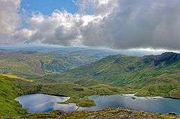 |
Wales Gwynedd Conwy 52°54′N 3°51′W / 52.900°N 3.850°W |
October 18, 1951 | 2,142 square kilometres (827.0 sq mi) | The largest national park in Wales, boasts the highest mountain in England and Wales, and Wales' largest natural lake. The area is steeped in culture and local history, where more than 90% its population speak Welsh[11] Fossil shell fragments on the summit of Snowdon date from over 500 million years ago and the ancient ‘Harlech Dome’ of which Snowdon and Cadair Idris form the northern and southern extents respectively, was created in the Cambrian Period before the volcanoes erupted. The more recent Ice Age glaciers were at their peak 18,000 years ago in Snowdonia and formed the distinctive U-shaped valleys including Llanberis and Nant Gwynant in the north and Tal-y-llyn Lake in the south.[3] |
| Dartmoor |  |
England Devon 50°34′N 4°0′W / 50.567°N 4.000°W |
October 30, 1951 | 956 square kilometres (369.1 sq mi) | Dartmoor is the largest and wildest area of open country in the south of England. Granite, intruded 295 million years ago underlies 65% of the park and is surrounded by sedimentary rocks including limestones, shales and sandstones belonging to the Carboniferous and Devonian periods. Almost half of the park is moorland, and within it are four separate national nature reserves, including the 366 hectare East Dartmoor Woods & Heath. There are also over forty locations designated as Sites of Special Scientific Interest within the national park covering 26,169 hectares. Dartmoor is also home to England's second highest waterfall (Canonteign Falls) and highest man made waterfall.[12] |
| Pembrokeshire Coast (Welsh: Arfordir Penfro) |
 |
Wales Pembrokeshire 51°50′N 5°05′W / 51.833°N 5.083°W |
February 29, 1952 | 620 square kilometres (239.4 sq mi) | The only UK national park recognised primarily for its coastline, it covers almost all the Pembrokeshire Coast, every offshore island, the Daugleddau estuary and large areas of the Preseli Hills and the Gwaun Valley. Regarded as one of the world’s best coastal destinations it is also an ecologically rich area recognised as of international importance for a wide range of high quality habitats and rare species. The park contains thirteen Special Areas of Conservation, five Special Protection Areas, one of three UK marine nature reserves and seven national nature reserves as well as sixty Sites of Special Scientific Interest.[13] The park also contains a wealth of human history and culture, including the UK's smallest city, St Davids and Iron Age forts. Within the park there are also a total of sixty geological conservation sites ranging from small roadside quarries and isolated crags on hilltops to many kilometres of coastline.[14] |
| North York Moors | 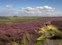 |
England North Yorkshire type:landmark source:dewiki 54°23′N 0°45′W / 54.383°N 0.750°W |
November 29, 1952 | 1,436 square kilometres (554.4 sq mi) | Boasting archaeology dating from the end of the last Ice Age, the park contains the largest Iron Age hill-fort in the North of England, Roman forts, castles and abbeys, moorland crosses and important early industrial sites.[15] Its ancient and varied geology includes the evidence left behind of ancient oceans, huge river deltas and great ice sheets. The evidence left behind by these events has brought geologists to the area for over a century, including figures such as William Smith, 'the father of English geology'. The area is also famous for its fossils, from ammonites to dinosaur footprints.[16] |
| Yorkshire Dales |  |
England North Yorkshire; Cumbria; Lancashire 54°16′N 2°05′W / 54.267°N 2.083°W |
November 16, 1954 | 2,179 square kilometres (841.3 sq mi) | The park straddles the central Pennines, known as the backbone of England. At the Millstone Grit-capped Three Peaks it rises to over 2,300 ft, contrasting with its deep cut valleys (dales) from which it derives its name. In the south the park boasts limestone (Karst) scenery, with its crags, pavements and extensive cave systems, whilst in the north valleys with distinctive stepped profiles are separated by extensive moorland plateaux. A different geology shapes the grassy rounded hills with deep ravines in the west known as the Howgill Fells. The park is noted for its glacial and post-glacial landforms including the drumlin fields, Norber erratics, and the moraines and post-glacial lakes of Semerwater and Malham Tarn. The park also boasts waterfalls including Hardraw Force and the Aysgarth Falls.[17][18] |
| Exmoor |  |
England Somerset;Devon 51°06′N 3°36′W / 51.100°N 3.600°W |
October 19, 1954 | 693 square kilometres (267.6 sq mi) | The majority of Exmoor's rocks were formed during the Devonian period of geological history between about 410 and 360 million years ago,[19] the most prominent being old and new red sandstones, Devonian slates, shales and limestone. The park rises to 519m at Dunkery Beacon and boasts 55 km of coastline towards which flow a number of rivers, most notably the River Lyn. In contrast the Exe flows south and east. A number of settlements are found within the park including the much visited Lynton and Lynmouth.[20] |
| Northumberland | 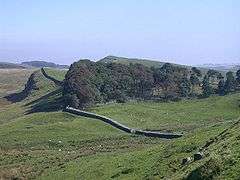 |
England Northumberland 55°19′N 2°13′W / 55.317°N 2.217°W |
April 6, 1956 | 1,049 square kilometres (405.0 sq mi) | With a population of around 2,000 people this is the least populated of all the national parks in England and Wales. Rising to 815m at The Cheviot, the park contains over 1,100 km of paths for walking, cycling and horse-riding. The park also contains a Ramsar site (an international site for the protection of wetlands) as well as 31 Sites of Special Scientific Interest, six Special Areas of Conservation and three national nature reserves. The park's human heritage is no less impressive than its natural diversity, with 259 listed buildings, 432 scheduled ancient monuments and 3,883 Historic Environment Records.[21] |
| Brecon Beacons (Welsh: Bannau Brycheiniog) |
Wales Blaenau Gwent, Carmarthenshire, Merthyr Tydfil, Powys, Rhondda Cynon Taf, Monmouthshire, Torfaen, Caerphilly 51°53′N 3°26′W / 51.883°N 3.433°W |
April 17, 1957 | 1,351 square kilometres (521.6 sq mi) | The park wholly encompasses Fforest Fawr Geopark. Geologically there is evidence of ancient seas, mountain building and sea level and climate change scattered across a landscape that was shaped by the last Ice Age. The underlying geology is overlaid with Old Red Sandstone peaks, open moorland, green valleys, hidden waterfalls and fern-filled gorges.[22] | |
| The Broads | 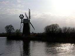 |
England Norfolk; Suffolk 52°43′27″N 1°38′27″E / 52.72417°N 1.64083°E |
April 1, 1989 | 303 square kilometres (117.0 sq mi) | Britain's largest nationally protected wetland, the Norfolk and Suffolk Broads is considered to be the eleventh member of the national park family, but in fact was designated through its own Act of Parliament in 1988 gaining similar status to a national park.[23] Its rivers, broads (shallow lakes), marshes and fens make this area rich in rare habitats, supporting myriad plants and animals. It is also one of Europe's most popular inland waterways. There are six rivers (Bure, Ant, Thurne, Yare, Chet and Waveney) and 63 broads within the park, comprising over 125 miles (200 km) of navigable waterways. The How Hill National Nature Reserve is wholly contained within the boundaries of the park, as well as 28 Sites of Special Scientific Interest, most of which fall under the Ramsar Convention on Wetlands of International Importance.[24] |
| New Forest | 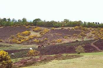 |
England Hampshire Wiltshire 50°52′N 1°34′W / 50.867°N 1.567°W |
March 1, 2005 | 580 square kilometres (223.9 sq mi) | England's smallest national park[25] was designated as a hunting ground by William the Conqueror almost 1,000 years before it became a national park and has its own section in the Domesday Book, in 1086. Originally the term 'forest' referred to the designation as a hunting ground subject to forest law, not to a collection of trees[25] and today less than half the national park is tree-covered (22,300 hectares).[26] The rest is heather- and bracken-covered heath, open pasture, marsh, villages and coastline, and the park contains the largest remaining lowland heath in Europe as well as three quarters of Europe's 120 lowland valley mires.[27] 38,000 hectares of the park is covered by the historic 'Perambulation' in which commoners’ rights apply and their animals can roam freely.[25] Amongst the 700 species of wildflower in the forest grow the blue marsh gentian and the bog orchid and the park is the only place in Britain where the wild gladiolus grows. The park is home to five types of deer, all species of British newt, all three native species of British snake, the UK’s largest breeding population of the Dartford warbler, the rare Southern Damselfly with thirty colonies, thirteen native species of British bat and the New Forest cicada, rediscovered in 1962.[28] The park also contains a wealth of human history with 214 scheduled ancient monuments.[29] |
| South Downs | .jpg) |
England East Sussex; Hampshire; West Sussex 50°54′40″N 0°22′01″W / 50.911°N 0.367°W |
March 31, 2010[30] 2010 (operational)[31] |
1,641 square kilometres (633.6 sq mi) | The most recently designated national park in the United Kingdom is a line of hills that run from Winchester in the west to Eastbourne in the east. The underlying geology of the eastern half, from the River Arun to Eastbourne, is mainly hills made of Chalk. To the west of the Arun, the area is wider and includes not only chalk hills but also part of the Weald made of sandstones and clay.[32] Most of the rocks that make up the South Downs were formed 120 million years ago, uplifted by earth movements and pushed up into a huge dome about 125 miles long and 50 miles wide which was then worn away to form the North Downs, South Downs and the plain of the Weald.[33] Amongst the key habitats overlaying this geology are chalk grassland, lowland heath and floodplain grazing marsh. The park rises to 280 metres at Blackdown in Sussex.[34] The park has the highest population of any national park in the UK which at 107,929 is bigger than the next two largest combined (Lake District: 42,000 and Peak District: 38,000). The park has a wealth of cultural heritage from evidence in Boxgrove of the earliest humans, through to contemporary arts, such as Edward James’ collection of surrealist art at West Dean College.[35] The park contains 600 Scheduled Monuments, over 5,000 listed buildings, two registered battlefields and 165 conservation areas.[34] |
See also
References
- ↑ Natural England - National Parks Archived 2012-05-18 at the Wayback Machine.
- 1 2 History of the National Parks - National Parks official site Archived 2013-04-21 at the Wayback Machine.
- 1 2 The Geology of Snowdonia Archived 2013-09-16 at the Wayback Machine.
- 1 2 3 4 5 National Park facts and figures Archived 2012-05-13 at the Wayback Machine.
- ↑ Natural England - AONB
- ↑ Natural England - facts and figures
- ↑ "World Heritage List". UNESCO World Heritage Centre. Retrieved 6 February 2010.
- ↑ "National Parks Listed in Chronological Order of Date Designated". National Parks. 27 June 2005. Archived from the original on 21 April 2013. Retrieved 6 March 2012.
- ↑ Roly Smith, Andrew Bibby (Andrew Bibby – ed) Peak District: Eastern Moors and the South - Volume 5 of Freedom to Roam Series, pp22-23 (Frances lincoln ltd), 2005, ISBN 9780711224988
- ↑ Lake District National Park - What's So Special?
- ↑ Snowdonia National Park
- ↑ Dartmoor National Park Authority - General Fact Sheet
- ↑ 60 facts for 60 years from the Pembrokeshire Coast National Park official site
- ↑ Geological Conservation from the Pembrokeshire Coast National Park official site
- ↑ www.northyorkmoors.org.uk/archaeology/ Archived 2012-09-05 at Archive.is
- ↑ www.northyorkmoors.org.uk/geology/ Archived 2012-09-10 at Archive.is
- ↑ www.yorkshiredales.org.uk/specialplace/specialquality-landscape Archived 2012-05-30 at the Wayback Machine.
- ↑ www.yorkshiredales.org.uk/specialplace/specialquality-nature Archived 2012-05-29 at the Wayback Machine.
- ↑ www.exmoor-nationalpark.gov.uk/learning/exmoors-geology Archived 2012-03-27 at the Wayback Machine.
- ↑ www.exmoor-nationalpark.gov.uk/learning/exmoor-facts
- ↑ www.northumberlandnationalpark.org.uk/understanding/factfile Archived 2013-01-04 at the Wayback Machine.
- ↑ www.breconbeacons.org/visit-us/things-to-do-and-see/pocket-guide/attachment_download/file Archived 2012-04-06 at the Wayback Machine.
- ↑ The Broads is not governed by the Sandford Principle meaning that rights of way and navigation rights are protected. Whilst not strictly a national park the Broads is considered to be 'a member of the national parks family'. The legislation covering the Broads is unique.What is a National Park? at http://www.nationalparks.gov.uk Archived 2012-06-08 at the Wayback Machine.
- ↑ www.broads-authority.gov.uk/education/about-the-broads.html Archived 2006-02-09 at the Wayback Machine.
- 1 2 3 www.newforestnpa.gov.uk/learning-about/figures/numbers-30,000-to-120m
- ↑ www.newforestnpa.gov.uk/learning-about/figures/numbers-1,000-to-30,000 Archived 2012-03-15 at the Wayback Machine.
- ↑ www.newforestnpa.gov.uk/learning-about/facts/facts-landscape Archived 2012-03-14 at the UK Government Web Archive
- ↑ www.newforestnpa.gov.uk/learning-about/facts/wildlife-and-nature Archived 2012-03-14 at the UK Government Web Archive
- ↑ www.newforestnpa.gov.uk/learning-about/figures/numbers-0-to-1,000 Archived 2012-04-18 at the Wayback Machine.
- ↑ "New South Downs National Park announced". Defra. 31 March 2009. Archived from the original on April 3, 2009. Retrieved 31 March 2009.
- ↑ "South Downs National Park Confirmed". DEFRA. Archived from the original on 2009-10-23. Retrieved 2009-11-12.
- ↑ "Great Britain's 15 National Parks". Gulgasht.com. Archived from the original on 2014-10-01. Retrieved 29 September 2014.
- ↑ Archived June 10, 2011, at the Wayback Machine.
- 1 2 www.southdowns.gov.uk/learning/facts-and-figures Archived 2012-06-28 at the Wayback Machine.
- ↑ http://www.southdowns.gov.uk/learning/themes-to-study/cultural-heritage Archived 2012-04-07 at the Wayback Machine.
External links
| Wikimedia Commons has media related to National parks of England. |
| Wikimedia Commons has media related to National parks of Wales. |