Cantref
A cantref (Welsh pronunciation: [ˈkantrɛ(v)]; plural cantrefi) was a medieval Welsh land division, particularly important in the administration of Welsh law.
Description
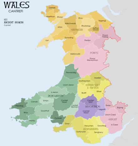
Land in medieval Wales was divided into cantrefi, which were themselves divided into smaller cymydau (commotes).[1] The word cantref is derived from cant ("a hundred") and tref ("town" in modern Welsh, but formerly used for much smaller settlements). The cantref is thought to be the original unit, with the commotes being a later division. Cantrefi could vary considerably in size: most were divided into two or three commotes, but the largest, the Cantref Mawr (or "Great Cantref") in Ystrad Tywi (now in Carmarthenshire) was divided into seven commotes. To give an idea of the size of a cantref, the island of Anglesey was divided into three cantrefi: Cemais, Aberffraw and Rhosyr.
History
The antiquity of the cantrefi is demonstrated by the fact that they often mark the boundary between dialects. Some were originally kingdoms in their own right; others may have been artificial units created later.[2]
Cantrefi were of particular importance in the administration of the Welsh law. Each cantref had its own court, which was an assembly of the uchelwyr, the main landowners of the cantref. This would be presided over by the king if he happened to be present, or if he was not present, by his representative. Apart from the judges there would be a clerk, an usher and sometimes two professional pleaders. The cantref court dealt with crimes, the determination of boundaries, and inheritance. The commote court later took over many of the functions of the cantref court, and in some areas the names of the commotes are much better known than the name of the cantref of which they formed parts.
The Cantrefi of Wales
| Deheubarth | Kingdom of Gwent | Kingdom of Gwynedd | Kingdom of Powys | Morgannwg | Rhwng Gwy a Hafren |
|---|---|---|---|---|---|
See also
Citations
References
- Koch, John T., ed. (2005), Celtic Culture: a historical encyclopedia, ABC-Clio (published 2006), ISBN 978-1-85109-440-0
- Lloyd, John Edward (1911), A History of Wales from the Earliest Times to the Edwardian Conquest, I (2nd ed.), London: Longmans, Green, and Co (published 1912)
- RCAHMW (2017), Mapping the Historic Boundaries of Wales: Commotes and Cantrefs, Aberystwyth: Royal Commission on the Ancient and Historical Monuments of Wales
- Fulton, Helen (2018), Mapping the Marches of Wales, Bristol: The University of Bristol
Further study
- Kocourek, Albert; Wigmore, John H., eds. (1915). "Laws of Howel Dda". Sources of Ancient and Primitive Law. Translated by Owen, Aneurin. Boston: Little, Brown, and Company. pp. 519–553.
- Lewis, Hubert (1889). Lloyd, John Edward, ed. The Ancient Laws of Wales. London: Elliot Stock.
- Probert, William, ed. (1823). The Ancient Laws of Cambria. London.
- Richards, G. Melville (1969). Welsh Administrative and Territorial Units, Medieval and Modern. Cardiff: University of Wales Press.
- Seebohm, Frederic (1904) [1895]. The Tribal System in Wales (2nd ed.). London: Longmans, Green, and Co.