Ynys Eilun
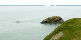 Ynys Eilun and Pont yr Eilun (left); on the right the slopes of Ynys Cantwr | |
 Ynys Eilun | |
| Geography | |
|---|---|
| Coordinates | 51°50′55.32″N 5°19′45.47″W / 51.8487000°N 5.3292972°WCoordinates: 51°50′55.32″N 5°19′45.47″W / 51.8487000°N 5.3292972°W |
| Area | 0.02[1] km2 (0.0077 sq mi) |
| Length | 0.26 km (0.162 mi)[2] |
| Administration | |
|
Wales | |
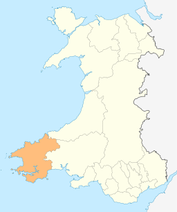
| County | Pembrokeshire |
| Demographics | |
| Population | 0 |
Ynys Eilun and Pont yr Eilun are two islets south-east of Ramsey Island, Pembrokeshire, Wales.
Geography
Ynys Eilun is located about a quarter of a mile eastward of Ynys Bery.[3] Visiting the island is not easy because of its difficult landing.[4] The waters surrounding the island are swept by a northeast current caused by the island itself.[5]
See also
References
- ↑ Richard Deacon, Islands of England and Wales, Osprey Publishing, 1974, p. 228 ("Area: 5 acres.").
- ↑ Ynys Eilun, gb.geoview.info
- ↑ The Geology of the South Wales Coal-field. Geological Survey of Great Britain. 1914. p. 67. Retrieved 2016-04-10.
- ↑ The Nautical Magazine and Naval Chronicle ... Simpkin, Marshall & Company. p. 397. Retrieved 2016-04-10.
- ↑ Jim Krawiecki and Andy Biggs (2006). Welsh Sea Kayaking: Fifty Great Sea Kayak Voyages. Pesda Pres. p. 179. Retrieved 2016-04-10.
External links
![]()
- Map sources for Ynys Eilun
- grid reference SM708219 — Pont yr Eilun
This article is issued from
Wikipedia.
The text is licensed under Creative Commons - Attribution - Sharealike.
Additional terms may apply for the media files.