Preseli Hills
.jpg)
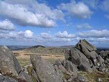
The Preseli Hills or, as they are known locally and historically, Preseli Mountains (Welsh: Mynyddoedd y Preseli / Y Preselau—also spelt Presely or Mynydd Prescelly[1]) is a range of hills in north Pembrokeshire, West Wales, mostly within the Pembrokeshire Coast National Park.
The range stretches from Dinas Island, Cardigan Bay to Frenni Fach, near Crymych approximately 13 miles (20 km) to the east. The ancient 8-mile (13 km) track along the top of the range is known as the Golden Road.[2][3]
The Preselis have a diverse ecosystem, many prehistoric sites, and are a popular tourist destination.
Geography
The mountains, much of which are unenclosed moorland or low-grade grazing with areas of bog, are surrounded by farmland and active or deserted farms. Field boundaries tend to be earth banks topped with fencing and stock-resistant plants such as gorse.[4]
Peaks
The principal peak at 1,759 feet (536 m) above sea level is Foel Cwmcerwyn. There are 14 other peaks over 980 feet (300 m) of which three exceed 1,300 feet (400 m).
| Peak | Height | Image | Notes |
|---|---|---|---|
| Foel Cwmcerwyn | 536 m (1,759 ft) | 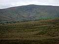 | Highest peak; cairns; disused quarry |
| Cerrig Lladron | 468 m (1,535 ft) | 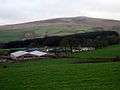 | |
| Foel Feddau | 467 m (1,532 ft) | 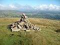 | |
| Carn Siân | 402 m (1,319 ft) | 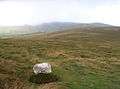 | |
| Frenni Fawr | 395 m (1,296 ft) | 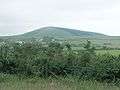 | Tumuli; see also Blaenffos |
| Mynydd Bach | 374 m (1,227 ft) | 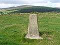 | Stone circle, standing stone, tumulus[5] |
| Foel Dyrch | 368 m (1,207 ft) | 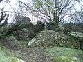 | |
| Carn Menyn | 365 m (1,198 ft) | 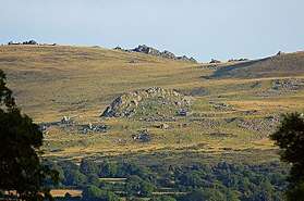 | Bluestones |
| Foel Drygarn | 363 m (1,191 ft) | 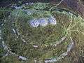 | Hill fort (English: Three Cairns) |
| Crugiau Dwy | 359 m (1,178 ft) | Preseli transmitting station | |
| Mynydd Carningli | 347 m (1,138 ft) |  | |
| Mynydd Castlebythe | 347 m (1,138 ft) | 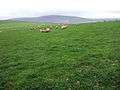 | |
| Waun Mawn | 339 m (1,112 ft) | ||
| Mynydd Cilciffeth | 335 m (1,099 ft) |  | |
| Mynydd Melyn | 307 m (1,007 ft) | 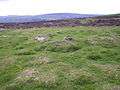 |
Settlements
Villages and other settlements within the range are Blaenffos, Brynberian, Crosswell, Crymych, Cwm Gwaun, Dinas Cross, Glandy Cross, Mynachlog-ddu, New Inn, Pentre Galar, Puncheston, Maenclochog, Rosebush and Tafarn-y-Bwlch. The principal town in the area is Newport, on the flank of the Carningli-Dinas upland.
Other features
Rosebush Reservoir, one of only two reservoirs in Pembrokeshire, supplies water to southern Pembrokeshire and is a brown trout fishery[6] located on the southern slopes of the range near the village of Rosebush. To the south is Llys y Fran reservoir. There are no natural lakes in the mountains, but a number of local rivers are fed from springs or bogs in the uplands.[7]
The Preselis have Special Area of Conservation status; the citation states that the area is "...exceptional in Wales for the combination of upland and lowland features...". Numerous scarce plant and insect species exist in the hills.[8] The hills are the most important site in Wales for the declining Southern damselfly, and efforts to restore habitat were underway in 2015.[9]
Pre-history and bluestones
Pollen analysis suggests that the hills were once forested but the forests had been cleared by the late Bronze Age.[8]
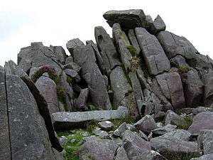
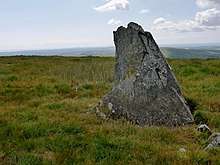
The Preselis are dotted with prehistoric remains, including evidence of Neolithic settlement. In 1923 the petrologist Herbert Henry Thomas proposed that bluestone from the hills corresponded to that used to build the inner circle of Stonehenge,[10] and later geologists suggested that Carn Menyn (formerly called Carn Meini) was one of the bluestone sources.[11] Recent geological work has shown this theory to be incorrect. [12] It is now thought that the bluestones at Stonehenge and fragments of bluestone found in the Stonehenge "debitage" have come from multiple sources on the northern flanks of the hills,[13] such as at Craig Rhos-y-felin.[14] Advanced details of a recent contribution to the puzzle of the precise origin of the Stonehenge bluestones were published by the BBC in November 2013.[15]
Others theorise that bluestone from the area was deposited close to Stonehenge by glaciation.[16]
More detailed discussions on the bluestone topic can be found in the Stonehenge, Theories about Stonehenge and Carn Menyn articles.
Sacred and historic sites

The mountains are rich in sacred and historic sites,[4] many of which are marked on Ordnance Survey maps.[7] They include burial chambers, tumuli, hill forts, hut circles, stone circles, henges, standing stones and other prehistoric remains.
Some of the more notable are -
- Bedd Arthur (hengiform standing stones)
- Mynydd Carningli (hillfort, SSSI)
- Carn Menyn (chambered cairn)
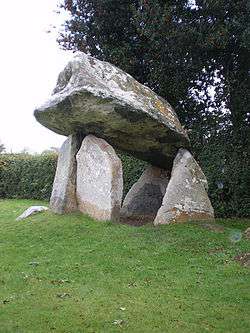
- Carreg Coetan Arthur (neolithic dolmen)
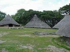
- Castell Henllys (reconstructed Iron Age fort)
- Temple Druid (standing stone, cromlech)
- Pentre Ifan (burial chamber).
Others include -
- Banc Du (evidence of prehistoric settlement)
- Carn Alw (neolithic settlement)[17]
- Carn Goedog (bluestones and standing stone)[18]
- Foel Drygarn (hillfort)[19][20]
- Foel Cwmcerwyn (tumuli)
- Frenni Fach & Frenni Fawr (tumuli - see also Blaenffos)
- Glandy Cross (prehistoric remains)
- Glyn Gath (tumulus)
- Gors Fawr (stone circle)[21]
- Mynyedd Melyn (hut circle)[22]
- Parc-y-Meirw (standing stones)[23]
- Rhos fach (standing stones)[24]
- Tafarn y Bwlch (mountain pass and standing stones)[25]
- Tre-Fach (standing stone, prehistoric camp)
- Ty-Meini (standing stone, known as "The Lady Stone"[26])
- Waun Mawn (standing stones).[27]
Most of these sites (and others) are on the List of Scheduled prehistoric Monuments in north Pembrokeshire, spread across a number of communities that share parts of the Preseli range.
In 2010, Dyfed Archaeological Trust carried out a comprehensive survey of historic sites in the Preseli Hills for Cadw.[17]
History
Slate quarrying was once an important industry in the Preseli mountains; the former quarries, worked for much of the 19th century, can still be seen in a number of locations such as Rosebush.[28] Preseli slate was not of roofing quality, but its density made it ideal for machining for building and crafts.[29] Most quarries had closed by the 1930s[30] but there is a workshop at Llangolman where slate is still used to make a variety of craft items.
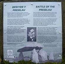
During the Second World War, the War Office used the Preseli mountains extensively for training exercises by British and American air and ground forces.[31][32] Its proposed continued use after the war was the subject of a two-year—ultimately successful—protest by local leaders.[33] The success of the protest is commemorated with a plaque (pictured) near Mynachlog-ddu.
Today
The Preselis provide hill grazing for much of the year and there is some forestry. The hills are popular with walkers wishing to follow prehistoric trails,[34] with walks varying from easy to long-distance. Horse riding and cycling are permitted, but the sport of paragliding is not permitted without the consent of the land owners - and they have collectively agreed not to allow it.[35]
As well as features of interest to geologists and archaeologists, the hills have a wide variety of bird, insect and plant life. There are three sites of special scientific interest (SSSIs): Carn Ingli and Waun Fawr (biological), and Cwm Dewi (geological).
One major road, the A478, crosses the eastern end of the range, reaching a height of 248 metres (814 ft). Two B-class roads, intersecting at New Inn, cross the hills: the B4313 NW-SE, reaching 278 metres (912 ft) and the B4329 NE-SW, reaching 404 metres (1,325 ft). These, and a number of other minor roads and lanes, provide scenic routes popular with motoring, cycling and walking tourists. Some grazing areas are protected by cattle grids.[7]
The Preseli transmitting station mast, erected in 1962, stands on Crugiau Dwy near the hamlet of Pentre Galar. To the south of Crugiau Dwy is the extensively quarried hill Carn Wen (Garnwen Quarry) in which blasting for aggregates restarted in 2013.
Dyfed Archaeological Trust has produced extensive notes on the mountain range and surrounding features and villages.[4]
References
- ↑ OS One inch 7th series map sheet 138/151 Fishguard and Pembroke 1965
- ↑ "BBC: Wales nature and outdoors". BBC. Retrieved 22 Nov 2013.
- ↑ "The Golden Road". Pembrokeshire Coast National Park Authority. Retrieved 22 Nov 2013.
- 1 2 3 "Dyfed Archaeological Trust: Preseli". Retrieved 4 Apr 2014.
- ↑ "Dyfed Archaeological Trust - Mynydd Bach". Retrieved 3 May 2014.
- ↑ "Rosebush Reservoir". Retrieved 28 Apr 2014.
- 1 2 3 OS Landranger Series, Map 145 Cardigan & Mynydd Preseli 2007
- 1 2 "Mynydd Preseli - Countryside Council for Wales". Retrieved 28 Apr 2014.
- ↑ "Conservationists restore habitat for endangered species". Western Telegraph. 12 April 2015. Retrieved 12 April 2015.
- ↑ Thomas, H.H. (1923). The source of the stones of Stonehenge. Antiquaries Journal 3, 239-260.
- ↑ "Archaeologists Figure Out Mystery of Stonehenge Bluestones". WalesOnline. 2005. Retrieved 20 Nov 2013.
- ↑ Ixer, R.A. and Bevins, R.E. (2013). Chips off the old block: the Stonehenge debitage dilemma. Archaeology in Wales 52 11-22.
- ↑ Bevins, R.E., Ixer, R.A., Webb, P.C. and Watson, J.S. (2012). Provenancing the rhyolitic and dacitic components of the stonehenge landscape bluestone lithology: New petrographical and geochemical evidence. Journal of Archaeological Science, 39 (4). p. 1005–1019.
- ↑ "Stonehenge 'bluestone' quarries confirmed 140 miles away in Wales". University College London. Retrieved 7 June 2018.
- ↑ Neil Prior (19 November 2013). "Another piece in Stonehenge rock source puzzle". BBC News. Retrieved 7 June 2018.
- ↑ Thorpe, R.S; et al. (1991). The geological sources and transport of the bluestones of Stonehenge, Wiltshire. Proceedings of the Prehistoric Society, 57, 103-57.
- 1 2 Scheduling Enhancement Project 2010: Prehistoric Sites Fieldwork - Pembrokeshire (PDF). Retrieved 27 Apr 2014.
- ↑ "Carn Goedog standing stone". Retrieved 27 Apr 2014.
- ↑ "The Megalithic Portal: Foel Drygarn". Retrieved 22 Nov 2013.
- ↑ "Pembrokeshire Virtual Museum - Foel Drygarn". Retrieved 27 Apr 2014.
- ↑ "Gors Fawr Stone Circle". Retrieved 27 Apr 2014.
- ↑ "Archaeology in Wales: Mynydd Melyn". Retrieved 27 Apr 2014.
- ↑ "Parc y Meirw Stone Row". Retrieved 27 Apr 2014.
- ↑ "Dyfed Archaeological Trust: Rhos Fach". Retrieved 27 Apr 2014.
- ↑ "Geograph: Tafarn y Bwlch from Eglwyswrw (photograph)". Retrieved 27 Apr 2014.
- ↑ Lloyd; et al. (2004). Pembrokeshire. Yale University Press. p. 184.
- ↑ An Inventory of the Ancient Monuments of Wales and Monmouthshire, Vol.VII. Royal Commission. 1925. p. 260.
- ↑ "Pembrokeshire Virtual Museum - Rosebush". Retrieved 29 Apr 2014.
- ↑ Richards, A.J. (1998). The Slate Quarries of Pembrokeshire. Gwasg Carreg Gwalch. ISBN 0863814840.
- ↑ The Slate Industry in Pembrokeshire. Pembrokeshire Record Office. 2004.
- ↑ "Pembrokeshire Military History Guide". Retrieved 23 June 2014.
- ↑ "Dyfed Archaeological Trust: Twentieth Century Military Sites: Camps and Ranges in Preseli District" (PDF). Retrieved 29 March 2018.
- ↑ Wyn, Hefin (2008). Battle of the Preselau. ISBN 978-0-9549931-3-9. (editions in Welsh and English)
- ↑ "Dyfed Archaeology: Mynydd Carningli - Mynydd Melyn" (PDF). Retrieved 27 Apr 2014.
- ↑ "Paragliders banned from Preseli Hills". Retrieved 1 May 2014.
Further reading
External links
| Wikimedia Commons has media related to Preseli Hills. |