B4329 road
The B4329 is a scenic route and a former turnpike in Pembrokeshire, West Wales. It links Eglwyswrw and Haverfordwest in an approximately north–south direction , by crossing the Preseli Mountains. The road is 19 miles (31 km) long and varies in elevation from 100–404 metres (328–1,325 ft) above sea level. Much of the route is through farmland with scattered settlements with a section through high moorland grazing with extensive views.[1][2]
History
The road has been the main link between Eglwyswrw and Haverfordwest since mediaeval times, and was subsequently turnpiked. In Lewis's 1833 Topographical Dictionary of Wales[3] it is described as the "great road" linking Cardigan with Haverfordwest. While the A487 (Cardigan to Fishguard) and the A40 (Fishguard to Haverforwest) sections were later upgraded to trunk routes, the direct route was not, and was designated in the early 20th century road classification scheme as the B4329.
From the 1920s to 1935, the B4329 was a multiplex with the A487 and an unclassified road from Boncath but reverted to the original start point in Eglwyswrw. The unclassified road became the B4332.[4][5] Before that, when most journeys were made on foot, horseback or horse-drawn vehicle, travellers were provided for by inns along the route, such as those at Crosswell, Tufton, Greenway and Crundale.
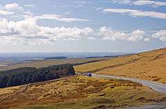
Extensive views
From the high moorland, there are extensive views across much of Pembrokeshire with the Bristol Channel, St George's Channel and the Irish Sea beyond. On clear days there are views as far as the Gower Peninsula in the southeast, much of mid-Wales to the north as far as Snowdonia and the Llŷn Peninsula as well as across much of the Preseli range. It is also possible, atmospheric conditions permitting, to see the tops of mountains in Ireland over 100 miles away. The Preselis are noted for their many prehistoric sites, some of which are close to the B4329.
Because of the steep inclines in the mountains, few heavy goods vehicles use the route, which is popular with tourists and bikers.[6] In winter, the highest parts of the road can occasionally be closed when ice or snow make driving conditions dangerous.[7]
Route
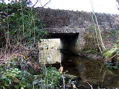
Branching from the A487, 1⁄2 mile (0.80 km) southwest of Eglwyswrw, the road drops down to cross the River Nevern by a single-lane stone bridge just north of the hamlet of Crosswell. The road enters the Pembrokeshire Coast National Park,[4] then climbs steadily through farmland, over a 400-year-old bridge crossing the Afon Brynberian, and past the hamlet of Brynberian with views of the mountains to the south and east.
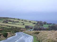
The gradient increases until the road passes the site of Tafarn-y-Bwlch (approximate English: Tavern at the Pass), an inn which existed at least as early as 1729.[8] The road crosses a cattle grid marking a boundary between enclosed agricultural land and unenclosed moorland and continues to climb to 404 metres (1,325 ft) between Carn Lladron and Mynydd-du Commin.
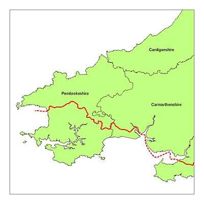
Now the route crosses the imaginary Landsker Line marking the change from the largely Welsh place names of north Pembrokeshire to the largely English place names in the south of the county. After the summit, the road drops steeply by Bwlch Gwynt to another cattle grid and the intersection with the B4313 at Greenway, also known as New Inn, which in the 19th century sustained northbound travellers before "the arduous task of winding up the painful ascent of Bwlch Gwynt".[9]
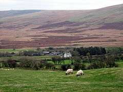
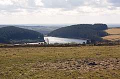
After the crossroads, the road slopes more gently downwards past Rosebush reservoir and Henry's Moat, leaving the National Park just before passing through the hamlet of Tufton. The road passes close by Llys y Fran Country Park, through the village of Woodstock and past Scolton Manor, then through the hamlets of Bethlehem and Poyston Cross and Crundale in Rudbaxton parish. The section between Greenway and Woodstock is on the 345 bus route.[10]
South of Crundale, the road crosses the bridge at Stephen's Ford, then crosses the A40 Haverfordwest bypass on a roundabout and ends at another roundabout in the centre of Haverfordwest connecting with the A40 spur (Cartlet Road) and the A487.
See also
References
- ↑ OS Landranger Map 145. Ordnance Survey. 2007.
- ↑ "Driving directions to Prendergast/B4329". Google Maps. Google. Retrieved 27 July 2014.
- ↑ "GENUKI: Meline". Retrieved 22 April 2015.
- 1 2 "Sabre Roader's Digest: B4329". Retrieved 1 August 2014.
- ↑ "Dyfed Archaeological Trust - Eglwyswrw". Retrieved 1 August 2014.
- ↑ "Best Biking Roads - Eglwyswrw to Haverforwest". Retrieved 1 August 2014.
- ↑ "B4329 road open". Western Telegraph. 15 January 2010. Retrieved 31 May 2014.
- ↑ "Dyfed Archaeological Trust: Mynydd Preseli". Retrieved 19 November 2014.
- ↑ Fenton, Richard (1811). A historical tour through Pembrokeshire. Longman, Hurst, Rees, Orme &Co. p. 348. Retrieved 3 December 2014.
- ↑ "Traveline-Cymru" (PDF). Archived from the original (PDF) on 10 August 2014. Retrieved 1 August 2014.
Transport in Pembrokeshire | ||
|---|---|---|
| Roads | 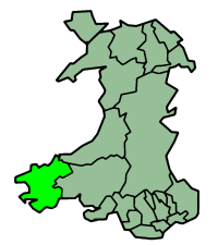 | |
| Cycling | ||
| Railway lines | ||
| Railway stations | ||
| Air | ||
| Sea | ||
External links
| Wikimedia Commons has media related to B4329 road (Wales). |