List of gaps in Interstate Highways
| Dwight D. Eisenhower National System of Interstate and Defense Highways | |
|---|---|
  | |
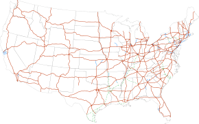 Interstate Highways in the 48 contiguous states | |
| System information | |
| Formed | June 29, 1956[1] |
| Highway names | |
| Interstates | Interstate X (I-X) |
| System links | |
There are gaps in the Interstate Highway system, where the roadway carrying an Interstate shield does not conform to the standards set by the Federal Highway Administration (FHWA), the body that sets the regulations for the Interstate Highway System. For the most part, the Interstate Highway System in the United States is a connected system, with most freeways completed; however, some Interstates still have gaps. These gaps can be due to unconnected segments of the same route or from failure of the road to fully conform to Interstate standards by including such things as at-grade crossings, traffic lights, undivided or narrow freeways, or movable bridges (lift bridges and drawbridges). This article deals with present-day gaps, as such examples were far more numerous during construction of the Interstate Highway System and the upgrading of existing roads to meet these standards, which did not occur everywhere at the same time. Temporary gaps, such as lane closures that reduce traffic to one lane and reduce speed limits, are also excluded.
True gaps
True gaps are where multiple disjoint sections of road have the same Interstate highway number and can reasonably be considered part of "one highway" in theory, based on the directness of connections via other highways, or based on future plans to fill in the gap in the Interstate, or simply based on the shortness of the gap. The sections are either not physically connected at all, or they are connected but the connection is not signed as part of the highway. This list does not include different highways that share the same number, such as the two different I-76s, I-84s, I-86s, I-87s, and I-88s, which were always intended as distinct highways and were never intended as a contiguous route.
Interstate 49
Interstate 49 (I-49) currently has four sections: the original alignment from I-10 in Lafayette to I-20 in Shreveport, one from Louisiana Highway 1 near Shreveport to Texarkana; the second section from I-40 near Alma, to US 71 south of Bella Vista, replacing most of I-540 and Arkansas Highway 549; and the last section from Pineville, to Kansas City, Missouri. A short, isolated section of I-49 exists in Bella Vista, Arkansas as Arkansas Highway 549. There is also a short section southeast of Fort Smith that is several miles long. These gaps are expected to be eventually closed.
Interstate 69
I-69 has seven sections: the original alignment travels from Indianapolis, Indiana, to Port Huron, Michigan. On October 2, 2006, a segment of I-69 opened in Tunica and DeSoto counties in Mississippi; this segment continues to Memphis, Tennessee, in the north. Another section exists from near Evansville, Indiana, to Bloomington, Indiana, and is under construction to Martinsville, Indiana; this section is expected to be connected to the original I-69 in Indianapolis in the next decade. Also in late 2011, the section of the Wendell H. Ford Western Kentucky Parkway between I-24 and the Pennyrile Parkway became signed as I-69. In 2012, a portion of U.S. Highway 59 (US 59) between Houston and Cleveland, Texas, became part of I-69.[2] On February 28, 2013, a portion of US 59 between Houston and Rosenberg, Texas, became part of I-69.[3] This gap was bridged by the signing of the portion between the two segments of US 59 as I-69 in March 2015.[4]
Interstate 74
I-74 currently has five sections,[5] the original segment heading northwest from Cincinnati, Ohio, to Davenport, Iowa; one from the Virginia–North Carolina line along I-77 south and east to a point southeast of Mount Airy, North Carolina; one traveling concurrently with US 311 around High Point connecting with I-85, and reaching I-73, where the two are concurrent until Ellerbe; and from west of Laurinburg to south of Lumberton, North Carolina, at I-95. North Carolina is currently working on connecting all its sections of I-74, though there are no plans to connect the southeastern extension of I-74 to Cincinnati for the foreseeable future.
Interstate 86
The eastern I-86 currently has two sections. One travels for 197 miles (317 km) from I-90 in North East, Pennsylvania, (which is a town in the northwestern part of the state) to exit 61 in Waverly, New York. The second section is a 9.9-mile (15.9 km) stretch outside of Binghamton traveling from I-81 in Kirkwood to exit 79 in Windsor. The gap is currently signed as Future 86. I-86 will eventually travel from North East, Pennsylvania, to the New York State Thruway (I-87) near Harriman, New York. All the designated sections and gaps in New York are part of New York State Route 17.
Interstate 99
I-99 currently has two sections: one from the Pennsylvania Turnpike north to just south of I-80, concurrent with US 220, and one from the Pennsylvania–New York state line north to the eastern I-86 in Corning, New York, concurrent with US 15. Much of the intervening route, including the entire US 15 section between I-180 in Williamsport and the New York state line, has been constructed to freeway standards but as yet is not signed as part of I-99.
The signing of that intervening route as I-99 will be completed when the route is upgraded to Interstate standards, and connecting the two segments of I-99.
Freeway gaps
Freeway gaps occur where the Interstate is signed as a continuous route, but part of it, if not all of it, is not up to freeway standards. This includes drawbridges where traffic on the Interstate can be stopped for vessels. This does not include facilities such as tollbooths, toll plazas, agricultural inspection stations, or border stations.
At-grade intersections and traffic lights
Several Interstates in rural areas of the U.S. have at-grade intersections (including median breaks) with minor farm access roads. This is usually due to the lack of an old highway; the need to provide access to property that was accessed via the road prior to its upgrade to an Interstate; and the high cost to construct an interchange for the small amount of traffic that would use such a connection or to build a frontage road parallel to the freeway to the nearest interchange. Other at-grade intersections are restricted to municipal service vehicles, of which make it easier for maintenance to be done in places like in the mountains as well as tollways.
- The northbound lanes of I-5 in Washington intersect with an at-level pedestrian crosswalk approximately 100 feet (30 m) south of the border with Canada. This crosswalk allows pedestrians access to a monument which is part of Peace Arch Park.[6]
- I-516 downgrades to an expressway as it heads toward its eastern terminus. The expressway features a frontage road right turn and an at-grade intersection with Mildred Street close to the terminus at Montgomery Street and Derenne Avenue (SR 21) in Savannah, Georgia. Mildred Street southbound is closed by concrete barriers.
- I-19 between North West Street and its southern terminus at West Crawford Street at North Sonotia Avenue, in Nogales, Arizona, consists of surface streets.
- I-10 and I-40 in remote areas of west Texas and eastern New Mexico have several at-grade access points for cattle ranches. I-40 also has at-grade access to dirt roads in the mountains of western North Carolina.
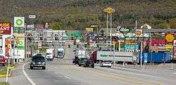
- I-70 uses part of US 30 along a surface road in Breezewood, Pennsylvania. Traffic traveling eastbound on I-70/I-76 must exit and travel a short distance on US 30 in order to continue south on I-70 heading to Hancock, Maryland. (The routing is similar for traffic following I-70 in the opposite direction: traffic traveling north on I-70 must exit and travel a short distance on US 30 in order to continue west on I-70/I-76 or to enter the Pennsylvania Turnpike.) This is probably the best-known instance of traffic lights on an interstate. There used to be a sign of a policeman pointing at drivers leaving the Pennsylvania Turnpike to enter US 30, saying, "You! Slow Down!" Local businesses have lobbied to keep the gap to avoid a perceived potential loss of business (Map).[7]
- I-676 has a surface street section at the west end of the Ben Franklin Bridge in Philadelphia, Pennsylvania, because of historically-significant areas. Signage and the Federal Highway Administration consider I-676 to use the surface streets; the Pennsylvania Department of Transportation and the New Jersey Department of Transportation consider I-676 to be continuous across the Ben Franklin Bridge, even though the bridge, built in 1926, is not up to Interstate standards (Aerial photo). This does not specifically violate Interstate standards, however, as the two separated segments of I-676 are in different states.
- I-78 travels along a one-way pair of surface streets, 12th Street and 14th Street, in Jersey City, New Jersey, between the end of the New Jersey Turnpike Newark Bay Extension and the Holland Tunnel, which leads into New York City. Between the two aforementioned points are four signalized intersections.[8]
- I-180 in Cheyenne, Wyoming, has no parts built to Interstate standard; in fact the interchange with I-80 is just a simple diamond interchange with two traffic lights on I-180. However, it is expressway-quality with a few grade separations (Map).
- I-585 in Spartanburg, South Carolina, is concurrent with US 176, in which I-585 shields are present beyond the point where it ceases to be a freeway, having passed through traffic lights. There also exists a sign that marks the road there as "I-585 Business Spur" and hence it is unclear whether that surface section of US 176 also belongs to I-585.
- I-587 in Kingston, New York has a traffic circle (with yield signs) at its northern terminus with the ramps leading to/from I-87.
- I-690 in Syracuse, New York, has a traffic light 12 days each year for buses to carry Great New York State Fair attendees from parking areas across the road to the fair.
- I-94 at Fort Custer west of Battle Creek, Michigan, is the only instance of an Interstate freeway in the state of Michigan to have a driveway, which facilitates access of military vehicles.[9]
Undivided and narrow freeways
This section addresses two-lane freeways and other narrow or undivided freeway sections of the Interstate, excepting instances of continuing routes using one-lane ramps and merge leads. Narrow gaps between opposing directions with jersey barriers taller than four feet (1.2 m) are excluded from this section; therefore the separation criteria is really either a 4-foot-tall (1.2 m) wall, or a 100-foot-wide (30 m) median, whichever is greater.
- I-40's western 15 miles (24 km) in North Carolina in the Harmon Den Wildlife Management Area has several S-curves, a Jersey barrier with extremely narrow left shoulders and a few at-grade intersections albeit in RIRO style.
- I-55 enters Tennessee from Arkansas on the Memphis and Arkansas Bridge which in itself would merit mention as a narrow through truss bridge. Just east of the bridge I-55 transitions from its east–west river crossing to the north–south alignment heading toward Jackson, Mississippi. There is an interchange that forces through I-55 traffic to enter and exit in a old cloverleaf; improvements are planned but are stalled. The improvements to the I-55 / Crump Boulevard interchange will be accomplished by constructing new through travel lanes for mainline I-55 traffic, which will eliminate the requirement for interstate traffic to use single-lane, low-speed ramps in order to continue on I-55. A new multi-lane roundabout intersection will be constructed to replace the existing cloverleaf interchange and provide improved access to and from I-55 and existing local roadways.[10]
- Interstate 70 is one-lane only for these following reasons:
- Interstate 70 in Kansas has only one lane for eastbound through traffic for several hundred feet in Kansas City where the highway approaches the Lewis and Clark Viaduct Bridge, which carries the highway over the Kansas River toward Kansas City, Missouri. Interstate 670, just a few blocks south provides an alternate route without this bottleneck.
- Interstate 70 in West Virginia has only one lane for approximately one thousand feet in Wheeling[11], where the highway enters the Wheeling Tunnel and crosses the Ohio River on the Fort Henry Bridge. Nearby I-470 provides relief from this situation.
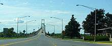
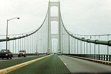
- The Mackinac Bridge, which carries I-75 over the Straits of Mackinac between St. Ignace and Mackinaw City, Michigan, has no wide median or hard shoulders due to space constraints. Nor does it have a Jersey barrier; instead, it has either a 4-inch-tall (10 cm) yellow divider between the opposing directions (where the inner lanes are a metal grate) or a flat double-yellow line (where the inner lanes are paved). The speed limit is also reduced to 45 mph (70 km/h) for cars and 20 mph (30 km/h) for trucks. The highway returns to Interstate standard for about 50 miles until it reaches the Sault Ste. Marie International Bridge, which carries undivided lanes to the Canada–US border in the middle of the bridge, where I-75 terminates.
- The Thousand Islands Bridge, which carries I-81 over part of the Saint Lawrence River, is an undivided two-lane road.
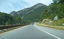
- I-93 is a two-lane divided parkway, or a "super two", through Franconia Notch in New Hampshire. A four-lane Interstate Highway was once proposed here, but the concept was abandoned because of environmental concerns, in part because of vibrations that could harm the Old Man of the Mountain rock formation (prior to the formation's 2003 collapse). This section of highway was for many years marked as US 3 and "To I-93", but these have now been replaced with regular I-93 signs. The Federal Highway Act of 1973 exempts this 7.6-mile (12.2 km) stretch from the Interstate Highway standards that apply elsewhere, and this highway is considered to be I-93 for all practical purposes.[12] This section of I-93 in New Hampshire is now the only remaining multi-mile section of two-lane freeway on an Interstate Highway in the United States.
- Some stretches of Interstate highway use a barrier transfer machine on some bridges to convert inner lanes from one direction to the other, where it would be too costly to upgrade/rebuild to a higher-capacity bridge. In any case the traffic distribution is strongly asymmetric depending on the hour of the day. This kind of bridge typically contains undivided lanes without the flexible Jersey barrier that is manipulated by machines.
Movable bridges
By Interstate standard, all bridges on the Interstate system must be fixed as to not interrupt the flow of traffic. Several bridges on the system, however, are movable:
- I-5 crosses the Columbia River from Portland, Oregon, to Vancouver, Washington, on the Interstate Bridge, a vertical-lift bridge. The Columbia River Crossing project sought to replace this bridge[13] until being abandoned in 2013.[14]
- I-110 has a drawbridge across the Back Bay of Biloxi in Biloxi, Mississippi.
- I-64—the Hampton Roads Beltway—crosses the South Branch Elizabeth River in Chesapeake, Virginia, on the High Rise Bridge, which is a drawbridge.
- I-264 has a drawbridge, the Berkley Bridge, crossing the Elizabeth River in Norfolk, Virginia.
- I-278 has a drawbridge across the Bronx River in New York City.
- I-280 has a drawbridge, the Stickel Memorial Bridge, crossing over the Passaic River between Newark and Harrison, New Jersey.
- I-95/I-495 pass together as the Capital Beltway over the Potomac River on the Woodrow Wilson Bridge, a double-leaf bascule span. Even though the original bridge was replaced in the 2000s, the new bridge also has a draw span, albeit with more vertical clearance resulting in fewer openings than the old bridge—about 65 per year, an average of about one every six days.
- I-695 has a drawbridge over Curtis Creek, south of Baltimore and just west of the Francis Scott Key Bridge. However, this section of the Baltimore Beltway is not part of the Interstate Highway System, and is officially Maryland Route 695 despite the Interstate signage on the highway.[15][16]
Freeway-to-freeway crosspaths without direct connection
- Interstate 422 (currently under construction) will have no direct freeway connection to Interstate 22, though the two routes will cross near Adamsville, Alabama.
- I-475 has no direct interchange with I-80/I-90 on the Ohio Turnpike.
- I-271 in Ohio also lacks a direct interchange with the I-80 section of the Ohio Turnpike; traffic interchanges between the two via Ohio State Route 8 which passes nearby.
- The Pennsylvania Turnpike mainline (I-70, I-76, and I-276) currently lacks several direct interchanges, including with I-81, I-95, and I-99. I-76 and I-81 are linked through a short stretch of US 11 in Middlesex Township, Cumberland County, Pennsylvania. I-276 and I-95 are being connected as part of the Pennsylvania Turnpike/Interstate 95 Interchange Project.
- I-476 and I-78 do not have a direct interchange in Lehigh County, Pennsylvania, though they are indirectly connected by US 22.
- The Massachusetts Turnpike (I-90) passes over I-391 without interchange in Chicopee, Massachusetts. The overpass is about one mile (1.6 km) north of the I-391 southern terminus at I-91, and approximately 1.4 miles (2.3 km) from the Mass Pike interchange with I-91 and US 5.
- I-195 passes over I-895 without interchange near Halethorpe, Maryland.
Connection gaps
Auxiliary Interstates (also known as three-digit Interstates) are intended to connect to their parent either directly or via a same-parented Interstate (like I-280 in California being connected to I-80 via I-680). Often, these connection gaps occur to eliminate concurrencies between other three-digit routes. Freeway gaps (signed or unsigned) that officially connect auxiliary routes to the parent are excluded.
Current day examples
- I-210 in California does not currently connect directly to I-10 or any of its spurs according to freeway signage. It was signed all the way to I-10 until 1998, when California State Route 57 replaced the portion of I-210 through Covina and San Dimas to provide a proper connection to current State Route 210. The former portion of I-210 now known as SR 57 still remains on the Interstate Highway System federally defined as Interstate 210[17] maintaining its connection to I-10, but it is not signed as per Caltrans tradition to sign state highways by their state definition over their federal definition. State Route 210, built as an extension to replace Route 30, connects to I-10, and California is petitioning to have that portion signed as I-210 as well. When that happens, this gap will close.
- Interstate 269 is near Memphis, Tennessee, but doesn't actually connect to Interstate 69 yet, since I-69 is still under construction.
- None of the spurs of I-78 in New York City (I-278, I-478, I-678, I-878) connect to its parent, nor is there any surface-street with a state route designation with the same number that continues with a solid connection. (see disputed gaps below)
- Interstate 585 near Spartanburg, South Carolina uses a business loop, albeit in freeway form of I-85, but this puts the example in some dispute of consensus (see disputed gaps below)
- Numerous three-digit Interstate routes are unsigned on some portions, which would lead some to think they were "connection gaps". However these aforementioned "connection gaps" don't even have internal unsigned concurrencies on other Interstate highway segments between the "parent route" and signed terminus.
Disputed gaps
Gaps where different criteria constitute contradictory circumstances.
- None of the spurs of I-78 in New York City (I-278, I-478, I-678, I-878) connect to their parent. I-78 was planned to extend southeast through New York City via the Lower Manhattan Expressway, Williamsburg Bridge and Bushwick Expressway, then east along what is now I-878 and north along what is now I-295. I-78 would have then split into two branches (the current I-295 and I-695), which would have both terminated at I-95.[18][19] I-478 comes the closest, and would have intersected I-78 as part of the Westway project;[20]:10 however, this project was later canceled.[21] I-278, the only I-78 spur to leave New York City, was planned to extend northwest to I-78 at Route 24.[22] Since all the spurs are interconnected, only one of them needs to be eventually connected to its parent route for all of them to conform to numbering standards.
- I-90 at the Chicago Skyway—historically, the Skyway was commonly considered to be, and was signed as, part of I-90 (although it was originally signed as part of Interstate 94). However, around 1999, the City of Chicago determined it may never have applied for approval to sign it as an Interstate. (It also is not designed to Interstate standards.) The city re-signed the Skyway, and it is now mostly posted with "TO I-90/94" signs with a few older signs remaining. However, the Illinois Department of Transportation has always and continues to report the Skyway as part of the Interstate system, and the Federal Highway Administration still considers it as such. An FHWA legal memo says "There is no doubt about it. The Chicago Skyway is officially part of I-90 that (has) always been included in the Dwight D. Eisenhower National System of Interstate and Defense Highways."[23][24]
In 2014, sign tabs with the word "TO" were removed from all I-90 signage; in early 2015, mile markers reflecting Interstate 90's distance from the Wisconsin state line, along with exit numbers for the corresponding interchanges along the Skyway, were installed, further reinforcing that the Chicago Skyway is officially part of Interstate 90.
Historical gaps
Interstate 95
Until September 2018, I-95 was discontinuous in Lawrence Township, New Jersey (near Trenton). Coming north from Philadelphia, Pennsylvania, I-95 looped around the north side of Trenton and ended at US 1, where it became I-295, which heads back south, heading to southern New Jersey. The other section of I-95 began on the Pennsylvania Turnpike at the Pennsylvania–New Jersey state line, headed east into New Jersey along a spur of the New Jersey Turnpike, then headed north along the New Jersey Turnpike mainline as it does today. Originally I-95 was planned to have left the alignment north of Trenton and headed northeast to I-287 and travel east along I-287 to exit 10 on the Turnpike, but this segment known as the Somerset Freeway was never built. Extensions over the years have taken I-95 several miles further north to the US 1 interchange northeast of Trenton, and along the New Jersey Turnpike to the Pennsylvania state line. Construction on an interchange to remove the gap began in 2010. The first phase, completed in fall 2018, connected the southern alignment with the Pennsylvania Turnpike, and I-95 was rerouted via it, with the part north of that interchange—up to US 1—becoming an extension of I-295.[25] With the completion of this interchange, I-95 is now a continuous highway from Florida to Maine.
See also

References
- ↑ Weingroff, Richard F. (Summer 1996). "Federal-Aid Highway Act of 1956, Creating the Interstate System". Public Roads. Washington, DC: Federal Highway Administration. 60 (1). Retrieved March 16, 2012.
- ↑ Special Committee on U.S. Route Numbering (May 19, 2012). "Report to SCOH" (PDF) (Report). Washington, DC: American Association of State Highway and Transportation Officials.
- ↑ "Alliance for I-69 Texas: More Houston Areas Freeway Added to Interstate 69". Alliance for I-69 Texas. February 28, 2013.
- ↑ "Texas Transportation Commission Minute Order" (PDF). Texas Transportation Commission. March 26, 2015.
- ↑ Malme, Bob. "I-74 North Carolina Progress Page". Archived from the original on July 25, 2010. Retrieved August 28, 2009.
- ↑ Joyce, Greg (January 25, 2006). "Shooting Closes Border". The Globe and Mail. Toronto. Retrieved July 3, 2018.
- ↑ Roig-Franzia, Manuel (November 22, 2001). "The Town That Stops Traffic: Travelers Encounter Way Station as Way of Life in Breezewood". The Washington Post. p. B1. (Subscription required (help)).
- ↑ Google (August 28, 2009). "Intersection of 14th St (ostensibly 78 West) and Erie St" (Map). Google Maps. Google. Retrieved August 28, 2009.
- ↑ Michigan Department of Transportation (n.d.). "Road & Highway Facts". Michigan Department of Transportation. Retrieved October 28, 2014.
- ↑ "Interstate 55/Crump Boulevard Interchange". Tennessee Department of Transportation. Retrieved 2017-08-03.
- ↑ https://www.google.com/maps/dir/40.0720684,-80.7258906/40.0723382,-80.7224505/@40.072251,-80.7247183,222m/data=!3m2!1e3!4b1!4m2!4m1!3e0?hl=en
- ↑ Weingroff, Richard (April 7, 2011). "Interstate System Conditions and Performance". Highway History. Federal Highway Administration. Retrieved August 20, 2012.
- ↑ Project staff. "Home". Columbia River Crossing. Oregon Department of Transportation and Washington State Department of Transportation. Retrieved August 28, 2009.
- ↑ Read, Richard (July 5, 2013). "Bridge Funds to Nowhere: Some of the $175 million in work for the now-defunct Columbia River Crossing might be useful someday, but much of it is just gone". The Oregonian. Portland. p. A1. Retrieved July 5, 2013.
- ↑ Highway Information Services Division (December 31, 2007). Highway Location Reference. Maryland State Highway Administration. Retrieved April 15, 2009.
- Anne Arundel County (PDF)
- ↑ Highway Services Division (2010). "Movable Bridges on State Maintained Highways" (PDF). Maryland State Highway Administration. Retrieved October 18, 2010.
- ↑ Federal Highway Administration. National Highway System: Los Angeles, CA (PDF) (Map). Scale not given. Federal Highway Administration. Retrieved February 5, 2012.
- ↑ New York City (Map). Rand McNally and Company. 1960. Retrieved April 15, 2010.
- Note that I-95 is shown on the Hutchinson River Parkway north of the Bruckner Interchange, but the 1955 "Yellow Book" map shows the I-78 route on the Bruckner Expressway.
- ↑ A Report on Airport Requirements and Sites in the Metropolitan New Jersey–New York Region. Port of New York Authority. 1961. p. 73. OCLC 2551801.
- ↑ West Side Hwy Project, New York: Environmental Impact Statement. West Side Hwy Project, New York: Environmental Impact Statement. New York State Department of Transportation; Federal Highway Administration, United States Department of Transportation. 1977. Retrieved March 19, 2018.
- ↑ Roberts, Sam (October 7, 1985). "THE LEGACY OF WESTWAY: LESSONS FROM ITS DEMISE". The New York Times. Retrieved March 22, 2018.
- ↑
- Union County Sheet 1 (Map). New Jersey Department of Transportation. 1967. Retrieved February 13, 2010.
- Union County Sheet 2 (Map). New Jersey Department of Transportation. 1967. Retrieved February 13, 2010.
- ↑ Office of Operations. "Tolling and Pricing Program". Federal Highway Administration. Archived from the original on February 4, 2012. Retrieved August 28, 2009.
- ↑ Samuel, Peter (June 29, 2005). "Skyway Is Interstate 90 Unless State Withdraws Reports: Feds". TollRoadsNews. Archived from the original on September 22, 2008.
- ↑ "I-95 to be redesignated as I-295 in Mercer County starting in 2018 - Redesignation part of the Pennsylvania Turnpike/I-95 interchange project". New Jersey Department of Transportation. Trenton, NJ. December 21, 2017. Retrieved January 1, 2018.
External links
| Signed | |
|---|---|
| Unsigned | |
| Lists | |
| Other | |
Major Interstates highlighted | |