St. Ignace, Michigan
| St. Ignace, Michigan | |
|---|---|
| City | |
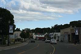 Downtown St. Ignace | |
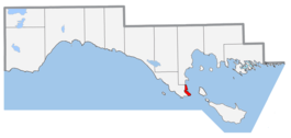 Location within Mackinac County | |
 St. Ignace, Michigan Location within Mackinac County | |
| Coordinates: 45°51′57″N 84°43′33″W / 45.86583°N 84.72583°WCoordinates: 45°51′57″N 84°43′33″W / 45.86583°N 84.72583°W | |
| Country | United States |
| State | Michigan |
| County | Mackinac |
| Area[1] | |
| • Total | 2.69 sq mi (6.97 km2) |
| • Land | 2.68 sq mi (6.94 km2) |
| • Water | 0.01 sq mi (0.03 km2) |
| Elevation | 587 ft (179 m) |
| Population (2010)[2] | |
| • Total | 2,452 |
| • Estimate (2016)[3] | 2,377 |
| • Density | 910/sq mi (350/km2) |
| Time zone | UTC-5 (Eastern (EST)) |
| • Summer (DST) | UTC-4 (EDT) |
| Area code(s) | 906 Exchanges: 242, 643 |
| FIPS code | 26-70840[4] |
| GNIS ID | 1621477[5] |
Saint Ignace, usually written as St. Ignace, is a city at the southern tip of the Upper Peninsula of the U.S. state of Michigan, on the northern side of the Straits of Mackinac. The population was 2,452 at the 2010 census. It is the county seat of Mackinac County.[6] For travelers coming from the Lower Peninsula, St. Ignace is the gateway to the northern part of the state.
St. Ignace Township is located just to the north of the city, but is politically independent.
Mackinac Bridge connects St. Ignace, at the northern end, and Mackinaw City, at the southern end,, linking what are known as the Upper and Lower peninsulas. Prior to construction of the bridge, people had to use boats or ferries to get across the water.
As of the 2010 census, nearly one-third of the population of the city identified as Native American. Jesuit priests established a mission in the 17th century at what was then a village of the Wyandot people, also known by the French as the Huron. They are an Iroquoian-language group. It became a center of fur trading with the French for regional peoples.
In the 18th century, the Ojibwe (known as Chippewa in the United States) also entered the area and were an important group near the Great Lakes. In the 21st century, the large, federally recognized Sault Ste. Marie Tribe of Chippewa Indians owns and operates a casino on its land in St. Ignace; it also has land and casinos in four other cities in northern Michigan.
The Mackinac Bands of Chippewa and Ottawa Indians, a state recognized tribe, is headquartered at St. Ignace. It also has bands in several other counties in the region. The Ottawa people, also known as Odawa, comprised another Algonquian-speaking tribe before European encounter. Their descendants joined with the Chippewa in this area to organize for self-government.
History
St. Ignace is the second-oldest city founded by Europeans in Michigan. Various cultures of Native Americans had inhabited the area for thousands of years before the first exploration here by French colonists. Early historic peoples of the area in the 17th century were predominantly the Iroquoian-speaking Wendat, whom the French called the Huron.
By the early 18th century, the Anishinaabe Ojibwe, who spoke one of the Algonquian languages, became prominent in the region. Another related Anishinaabe people were the Ottawa or Odawa in their language. The third member of the Council of Three Fires, a loose confederacy of these tribes, was the Potowatomi people. All three peoples have descendants who are members of various federally recognized tribes in northern Michigan.
French explorer and priest Jacques Marquette founded the St. Ignace Mission on this site in 1671 and was buried here after his death.[7] He named it for St. Ignatius of Loyola, founder of the Jesuit religious order, whose priests were active as missionaries across North America. (Ignace is the French version of Ignatius.) Jesuits served at missions to convert First Nations/Native Americans to Catholicism and to share French culture. In 1673, Marquette joined the expedition of Louis Jolliet, a French-Canadian explorer, and departed from St. Ignace on May 17, with two canoes and five voyageurs of French-Indian ancestry (Métis) on a voyage to find the Mississippi River. They were successful and descended downriver as far as Arkansas.
While separately exploring the Great Lakes region on the ship Le Griffon with Louis Hennepin, Sieur de La Salle reached St. Ignace on August 27, 1679. Louis de La Porte, Sieur de Louvigny founded Fort de Buade here in 1681 as a fur trading post. It was later directed by Antoine Cadillac. It was closed by the French in 1697.[8] The Jesuits abandoned their mission in 1705.
The Ojibwe, who came to dominate most of the Native American territory of present-day Michigan in the 18th century, were allies of the French in the Seven Years' War against the British. After the British victory in the Seven Years' War, in 1763 they took over the territory of France in North America, including this part of the former New France. After the victory of rebellious colonists in the American Revolutionary War, in 1783 the village was included within the new United States, as part of what became called its Northwest Territory.
An important fur trading site for both the French and the British, St. Ignace declined in importance by the early 19th century. The Ojibwe had allied with Great Britain in the War of 1812, based on their long trading and a hope they were expel American colonists. The fur trade declined at St. Ignace largely because the United States prohibited British Canadian traders from operating across the border after the end of the war. At the same time European demand for North American furs was declining as tastes changed, and other parts of the economy grew.
Both British-Canadians and later Americans operated a larger trading center at Sault Ste. Marie, which developed on both sides of the Canadian-US border, until the decline of the fur trade in the 1830s. The fur trade also suffered before and during the hostilities of the War of 1812, as the United States first imposed a boycott on all trade with England, including traders in Canada. Many local people kept businesses going by smuggling, but postwar prohibitions on the fur trade were more difficult to avoid. prohibited British traders from operating across the border, as had been their earlier practice. The Ojibwe had allied with the British, their longtime trading partners, during the War of 1812,
In 1882, construction of the Detroit, Mackinac and Marquette Railroad, which connected the straits area to the major city of Detroit, provided an economic boost to the village. Farmers and the lumber industry could more easily get products to a major market. St. Ignace was incorporated as a village on February 23, 1882, and as a city in 1883.[7]
In the late 19th century, a new sector of its economy developed, as it began to attract tourists as a popular summer resort and for its connection to Mackinac Island.
Since the late 20th century, the city has become a rural destination for heritage tourism and is part of a regional area popular for summer tourism. A variety of water sports and activities are available.
The Mackinac Bands of Chippewa and Ottawa Indians, a state-recognized tribe, is based in St. Ignace. It also has bands in several other counties in the region. With an enrolled membership of 4,000 in this area and state recognition, it has been seeking federal recognition since 1998. The larger federally recognized Sault Ste. Marie Tribe of Chippewa Indians, based in the city of that name and the region of northern Michigan, owns and operates a gaming casino in St. Ignace on land it controls in the city, in addition to land and casinos in four other cities in the state.
Geography
According to the United States Census Bureau, the city has a total area of 2.69 square miles (6.97 km2), of which 2.68 square miles (6.94 km2) is land and 0.01 square miles (0.03 km2) is water.[1]
Demographics
| Historical population | |||
|---|---|---|---|
| Census | Pop. | %± | |
| 1880 | 934 | — | |
| 1890 | 2,704 | 189.5% | |
| 1900 | 2,271 | −16.0% | |
| 1910 | 2,118 | −6.7% | |
| 1920 | 1,852 | −12.6% | |
| 1930 | 2,109 | 13.9% | |
| 1940 | 2,669 | 26.6% | |
| 1950 | 2,946 | 10.4% | |
| 1960 | 3,334 | 13.2% | |
| 1970 | 2,892 | −13.3% | |
| 1980 | 2,632 | −9.0% | |
| 1990 | 2,568 | −2.4% | |
| 2000 | 2,678 | 4.3% | |
| 2010 | 2,452 | −8.4% | |
| Est. 2016 | 2,377 | [3] | −3.1% |
| U.S. Decennial Census[9] | |||
2010 census
As of the census[2] of 2010, there were 2,452 people, 1,064 households, and 633 families residing in the city. The population density was 914.9 inhabitants per square mile (353.2/km2). There were 1,299 housing units at an average density of 484.7 per square mile (187.1/km2). The racial makeup of the city was 63.4% White, 1.0% African American, 27.8% Native American, 0.3% Asian, 0.2% from other races, and 7.3% from two or more races. Hispanic or Latino of any race were 1.1% of the population.
There were 1,064 households of which 27.0% had children under the age of 18 living with them, 43.3% were married couples living together, 11.1% had a female householder with no husband present, 5.1% had a male householder with no wife present, and 40.5% were non-families. 33.8% of all households were made up of individuals and 13.6% had someone living alone who was 65 years of age or older. The average household size was 2.24 and the average family size was 2.84.
The median age in the city was 44.5 years. 21.3% of residents were under the age of 18; 7.7% were between the ages of 18 and 24; 21.6% were from 25 to 44; 31.6% were from 45 to 64; and 17.7% were 65 years of age or older. The gender makeup of the city was 48.2% male and 51.8% female.
2000 census
− − − − − − − −
| Largest ancestries (2000) [10] | Percent
− |
|---|---|
| Ojibwe | 23%
− |
| German | 18%
− |
| Irish | 11%
− |
| French | 10%
− |
| English | 8%
− |
| Polish | 7%
− |
As of the census[4] of 2000, there were 2,678 people, 1,085 households, and 675 families residing in the city. The population density was 990.7 per square mile (383.0/km²). There were 1,232 housing units at an average density of 455.8 per square mile (176.2/km²). The racial makeup of the city was 71.81% White, 19.42% Native American, 0.56% Asian, 0.30% African American, 0.04% Pacific Islander, 0.19% from other races, and 7.69% from two or more races. Hispanic or Latino of any race were 0.90% of the population.
There were 1,085 households out of which 29.2% had children under the age of 18 living with them, 46.7% were married couples living together, 11.5% had a female householder with no husband present, and 37.7% were non-families. 31.6% of all households were made up of individuals and 15.0% had someone living alone who was 65 years of age or older. The average household size was 2.35 and the average family size was 2.96.
In the city, the population was spread out with 23.2% under the age of 18, 8.6% from 18 to 24, 27.4% from 25 to 44, 22.7% from 45 to 64, and 18.1% who were 65 years of age or older. The median age was 39 years. For every 100 females, there were 93.4 males. For every 100 females age 18 and over, there were 88.2 males.
The median income for a household in the city was $34,447, and the median income for a family was $45,893. Males had a median income of $29,813 versus $23,017 for females. The per capita income for the city was $17,340. About 6.0% of families and 9.0% of the population were below the poverty line, including 10.3% of those under age 18 and 9.5% of those age 65 or over.
Transportation


- Three ferry companies (Arnold Transit Company, Shepler's Ferry and Star Line Ferry) operate out of Saint Ignace, connecting tourists and commuters to Mackinac Island.
- The nearest airports with scheduled passenger service are in Chippewa County International Airport in Kinross (northeast of St. Ignace, adjacent to I-75) and Pellston Regional Airport[12] in the Lower peninsula.
- Indian Trails provides daily intercity bus service between St. Ignace and East Lansing, Michigan,[13] between St. Ignace and Bay City, Michigan,[14] and between St. Ignace and Ironwood, Michigan.[15]
Local sights and events
The St. Ignace area hosts contains Kewadin Casinos - St. Ignace, a casino and significant local employer. Other attractions include locations from where one can get a good look at the Mackinac Bridge. Wawatam Lighthouse, a lighthouse that guards the harbor, is a local landmark. Castle Rock, a geological limestone stack, is located three miles (5 km) north overlooking Lake Huron. Rabbit's Back, a prominent promontory that also overlooks Lake Huron, is 4 miles (6.4 km) north. Chain Lake, 1 mile (1.6 km) inland, features inland fishing opportunities. There are numerous civic events in St. Ignace.[16]
The harbor also is a port for Coast Guard ice breakers, e.g., the tug Katmai Bay[upper-alpha 1] and heavy duty breaker Mackinaw.[upper-alpha 2][19][20][21][22][23][24]
Notable people
- Prentiss M. Brown, U.S. Senator from Michigan[25]
- Les Sweetland, professional baseball pitcher
Images
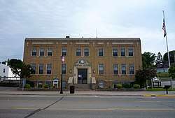
- Looking south in downtown St. Ignace
 Post office
 The ferry harbor with Mackinac Island in the distance
References
Notes
- ↑ Stationed at Sault Ste. Marie, Michigan.[17]
- ↑ The Mackinaw is stationed at Cheboygan, Michigan.[18]
Citations
- 1 2 "US Gazetteer files 2010". United States Census Bureau. Archived from the original on January 24, 2012. Retrieved November 25, 2012.
- 1 2 "American FactFinder". United States Census Bureau. Retrieved November 25, 2012.
- 1 2 "Population and Housing Unit Estimates". Retrieved June 9, 2017.
- 1 2 "American FactFinder". United States Census Bureau. Retrieved January 31, 2008.
- ↑ "US Board on Geographic Names". United States Geological Survey. October 25, 2007. Retrieved January 31, 2008.
- ↑ "Find a County". National Association of Counties. Retrieved June 7, 2011.
- 1 2 Sawyer, Alvah Littlefield (1911). A History of the Northern Peninsula of Michigan and Its People, p. 318. The Lewis Publishing Company
- ↑ Walter Romig, Michigan Place Names, p. 204
- ↑ "Census of Population and Housing". Census.gov. Retrieved June 4, 2015.
- ↑ http://www.epodunk.com/cgi-bin/genealogyInfo.php?locIndex=22113
- ↑ "Highway ends, US 2". state-ends.com. Archived from the original on May 12, 2007.
- ↑ "Pellston Regional Airport Serving Northern Michigan Emmet County". pellstonairport.com.
- ↑ "EAST LANSING-PETOSKEY-ST. IGNACE" (PDF). Indian Trails. January 15, 2013. Archived from the original (PDF) on June 29, 2014. Retrieved February 27, 2013.
- ↑ "BAY CITY-ALPENA-CHEBOYGAN-ST. IGNACE" (PDF). Indian Trails. January 15, 2013. Archived from the original (PDF) on July 24, 2013. Retrieved February 28, 2013.
- ↑ "ST. IGNACE-SAULT STE. MARIE-IRONWOOD" (PDF). Indian Trails. January 15, 2013. Archived from the original (PDF) on July 4, 2014. Retrieved February 28, 2013.
- ↑ "Your Home Port in the Straits of Mackinac Area". stignace.com. St. Ignace Visitors Bureau.
- ↑ "USCGCGC Katmai Bay (WTGB 101)". United States Coast Guard. January 26, 2012.
- ↑ "USCGC Mackinaw (WLBB-30)". United States Coast Guard. Retrieved May 1, 2017.
- ↑ King, Dominique (April 15, 2014). "From Monroe to Mackinac: Lighthouse moves to Chief Wawatam Park in St. Ignace,". Michigan Midwest Guest. Retrieved April 25, 2017.
- ↑ "U.S. Coast Guard Sector Sault Sainte Marie". U.S. Coast Guard Sector. Retrieved April 30, 2017.
- ↑ Heffernan, Tim (February 25, 2016). "Ice Breakers: The Coast Guard Crews That Keep the Great Lakes Open for Business". Popular Mechanics. Retrieved April 30, 2017.
- ↑ Ellison, Garret (January 8, 2015). "The freeze is on: Coast Guard begins ice-breaking on western Great Lakes". Mlive. Retrieved April 30, 2017.
- ↑ Final survey, Great Lakes-St.Lawrence Seaway Navigation Extension: Environmental Impact Statement. 5. Detroit, Michigan: U.S. Army Corps of Engineers. August 1979. p. 95. Retrieved April 30, 2017.
- ↑ "USCG Cutter Mackinaw Icebreaker Moored in Sault Ste. Marie, Michigan" (Video). March 20, 2014. Retrieved April 30, 2017 – via YouTube.
- ↑ "BROWN, Prentiss Marsh, (1889 - 1973)". Biographical Directory of the United States Congress. Retrieved October 14, 2012.
External links
| Wikimedia Commons has media related to St. Ignace, Michigan. |
Municipalities and communities of Mackinac County, Michigan, United States | ||
|---|---|---|
| Cities | 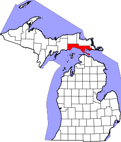 | |
| Townships | ||
| Unincorporated communities | ||
| Central cities | |
|---|---|
| Counties | |
| Geography | |
| Transportation | |
| Economy | |