Interstate 99
| |||||||
|---|---|---|---|---|---|---|---|
|
I-99 highlighted in red, unbuilt or unsigned portions in blue | |||||||
| Route information | |||||||
| Length | 98.86 mi[1] (159.10 km) | ||||||
| Existed | November 6, 1998[2] – present | ||||||
| Southern segment | |||||||
| Length | 85.780 mi[1] (138.050 km) | ||||||
| South end |
| ||||||
| Major junctions |
| ||||||
| North end |
| ||||||
| Northern segment | |||||||
| Length | 13.08 mi[3] (21.05 km) | ||||||
| South end |
| ||||||
| North end |
| ||||||
| Location | |||||||
| States | Pennsylvania, New York | ||||||
| Counties |
PA: Bedford, Blair, Centre NY: Steuben | ||||||
| Highway system | |||||||
| |||||||

Interstate 99 (I-99) is an Interstate Highway with two segments: one located in central Pennsylvania, and the other in southern New York[4] in the United States. The southern terminus of the route is near exit 146 of the Pennsylvania Turnpike (I-70 and I-76) north of Bedford, where the road continues south as U.S. Route 220 (US 220). The northern terminus of the Pennsylvania segment is near exit 161 of I-80 near Bellefonte. The New York segment follows US 15 from the Pennsylvania–New York border to an interchange with I-86 in Corning. I-99 passes through Altoona and State College—the latter home to Pennsylvania State University—and is entirely concurrent to US 220, within Pennsylvania. Long-term plans call for I-99 to be extended southward along the US 220 corridor to an interchange with I-68 in Cumberland, Maryland.
Unlike most Interstate Highway numbers, which were assigned by the American Association of State Highway and Transportation Officials (AASHTO) to fit into a grid, I-99's number was written into Section 332 of the National Highway System Designation Act of 1995 by Bud Shuster, then-chair of the U.S. House Committee on Transportation and Infrastructure, the bill's sponsor, and the representative of the district through which the highway runs. I-99 violates the AASHTO numbering convention associated with Interstate Highways, as it should lie to the east of I-97 but instead lies east of I-79 and west of I-81.
Route description
Pennsylvania
| mi | km | |
|---|---|---|
| PA | 85.78 | 138.05 |
| NY | 13.08 | 21.05 |
| 98.86 | 159.10 |
I-99 begins at an indirect interchange with US 220 and the Pennsylvania Turnpike (designated as I-70 and I-76) north of Bedford. It begins concurrent with US 220, which continues south from the interchange toward the Maryland state line as a two-lane highway known as the Appalachian Thruway. The interchange with the Turnpike requires drivers to use a short segment of US 220 Business to access the Turnpike at exit 146. North of the Turnpike junction, the limited-access highway becomes the Bud Shuster Highway as it heads through a rural portion of Bedford County. It connects to Pennsylvania Route 56 (PA 56) just west of the Bedford County Airport at exit 3 and PA 869 at exit 7 before crossing into Blair County. Here, it meets PA 164 north of East Freedom at exit 23 prior to entering the Altoona area.[5]
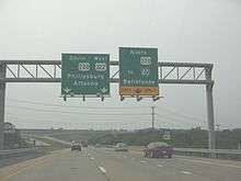
In Hollidaysburg, a borough south of the city, I-99 and US 220 connect to US 22 at exit 28, a large modified trumpet interchange. This junction allows travelers to head west towards Ebensburg, Johnstown, and Pittsburgh. The freeway continues to Altoona itself, where it indirectly connects to PA 36 via exit 32. Unlike the original routing of US 220 which goes through the city center, I-99 and US 220 mostly bypass it to the east, connecting to the city via streets leading eastward from the downtown district. At the northern edge of Altoona, PA 764 joins the old alignment of US 220 and parallels I-99 north for 3 miles (5 km) toward Bellwood. PA 764 leaves old US 220 about 2 miles (3.2 km) south of Bellwood, however, and terminates at I-99 exit 39. Bellwood itself is served by exit 41, which leads to PA 865.[5]
The highway veers northeastward from Bellwood to serve the borough of Tyrone, located at the junction of old US 220 and PA 453. Access to the borough is made by way of exit 48, which serves PA 453. Past Tyrone, I-99 and US 220 head through sparsely populated areas of Blair and Centre Counties. For this reason, only three exits exist between Tyrone and State College: exit 52, serving PA 350 and the small community of Bald Eagle, and exits 61 and 62, which connect to US 322 and the borough of Port Matilda. Here, US 322 joins I-99 and US 220 and follows them eastward to the State College area.[5]
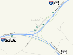
At exit 68 (US 322 Business), I-99 merges into the Mount Nittany Expressway, an older, northerly bypass of State College. I-99, US 220, and US 322 follow the expressway to the Mount Nittany Interchange, a directional T interchange located on the northern fringe of the Pennsylvania State University campus. Beaver Stadium, the home of the Penn State Nittany Lions football team, is visible from I-99 at this point. US 322 continues east through the interchange to follow the Mount Nittany Expressway while I-99 and US 220 split from US 322 and head northeastward toward Pleasant Gap, which I-99 connects to via exit 81 and PA 26. At this point, PA 26 joins the freeway and follows it to Bellefonte, served by exit 83 and PA 550. The southern segment of I-99 ends about 1 3⁄4 miles (2.8 km) later at an intersection with Musser Lane though the divided highway continues 1⁄3 mile (0.54 km) northeast to an interchange with I-80, where PA 26 continues north and US 220 joins I-80 east.[5]
New York
The northern segment of I-99 is entirely concurrent with US 15, and starts at the Pennsylvania-New York border north of Lawrenceville, Pennsylvania. A four-lane freeway through the Steuben County town of Lindley, I-99 crosses through a rock cut, making a large bend to the north and bypassing the hamlet of Presho. The freeway enters a partial cloverleaf interchange with CR 5 (Smith Road). After CR 5, I-99 turns northeast through the town of Erwin, running to the west of the Indian Hills Golf Club. Making a gradual bend further to the northeast, the freeway crosses the Canisteo River and enters the hamlet of Erwins, where it enters a diamond interchange with NY 417 (Addison Road). After NY 417, it then turns alongside Norfolk Southern Railroad's Southern Tier Line (former Erie Railroad main line). Now paralleling the tracks and NY 417, I-99/US 15 crosses through Erwin, entering exit 11, which connects to NY 417 once again, next to Gang Mills Yard,[6] the site of the former Painted Post station.[7]
After Gang Mills Yard, I-99 crosses through the Gang Mills section of Erwin, entering a large interchange at the northern end of the neighborhood. Signed exit 12, this interchange serves CR 107 (Robert Dann Drive) via NY 417. After CR 107, I-99 enters a large interchange that utilizes several flyover ramps between I-99, US 15, I-86, and NY 17 (the Southern Tier Expressway). Ramps are also present, connecting to NY 352. This interchange serves as the northern terminus of both I-99 and US 15.[6]
History
Origins
Corridor O of the Appalachian Development Highway System was assigned in 1965, running from Cumberland, Maryland (Corridor E, now I-68) to Bellefonte (I-80) along US 220.[8] The portion in Pennsylvania, from Bedford north to Bald Eagle, was upgraded to a freeway in stages from the 1960s to the 1990s. The first section, from US 30 in Bedford to Pennsylvania Route 56 (PA 56) near Cessna, opened in the latter half of the 1960s.[9][10] Two more sections—from PA 56 north to modern exit 15 in Blair County and from Charlottsville (exit 45) to Bald Eagle—were completed in the 1970s.[10][11] The portion between exit 15 and Altoona (exit 33) was finished in the 1980s[11][12] while the segment between modern exits 33 and 45 was opened by 1997.[13]
In 1991, the Intermodal Surface Transportation Efficiency Act (ISTEA) was signed into law.[14] It included a number of High Priority Corridors, one of which—Corridor 9—ran along US 220 from Bedford to Williamsport, and then north on US 15 to Corning, New York.[15] The National Highway System Designation Act of 1995 amended ISTEA; among these amendments were that "the portion of the route referred to in subsection (c)(9) [Corridor 9] is designated as Interstate Route I-99."[16] This was the first Interstate Highway number to be written into law rather than to be assigned by AASHTO. The number was specified by Representative Bud Shuster, who said that the standard spur numbering was not "catchy"; instead, I-99 was named after a street car, No. 99, that took people from Shuster's hometown of Glassport to McKeesport. I-99 violates the AASHTO numbering convention associated with Interstate Highways, since it lies east of I-79 but west of I-81.[17]
Designation and Bald Eagle Ridge
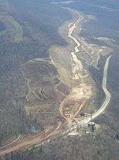
On November 6, 1998, AASHTO formally approved the I-99 designation, which initially extended 51.2 miles (82.4 km) from the Pennsylvania Turnpike in Bedford to PA 350 in Bald Eagle.[2] In 2002, plans were set in motion to extend I-99 northeast from Bald Eagle to State College via Port Matilda.[18] The extension was fraught with issues, however. The proposed alignment for the highway north to Port Matilda proved to be controversial: while environmentalists called for I-99 to be constructed in the valley below Bald Eagle Ridge, the Pennsylvania Department of Transportation (PennDOT) and valley residents favored a routing that took the freeway above the valley and along the side of the ridge.[19] Farther north, the widening of Skytop, the mountain cut that US 322 uses to traverse Bald Eagle Ridge, resulted in the exposure of acidic pyrite rock in 2003.[18]
Work on the segment ceased one year later[18] as PennDOT attempted to stop the flow of acidic runoff from the site. The state remedied the situation by removing 1,000,000 cubic yards (760,000 m3) of pyrite and replacing it with a mix of limestone and fill, a process that took two years and cost $83 million.[17] With the environmental issues settled, construction resumed on the portion of the freeway south of Skytop Mountain. The section from Bald Eagle to Port Matilda was opened to traffic on December 17, 2007,[20] while the remaining section between Port Matilda and the west end of the Mount Nittany Expressway near State College was completely opened on November 17, 2008.[18] In all, the Bald Eagle–State College section of I-99 cost $631 million to construct.[17]
I-99 was extended northeastward to meet I-80 northeast of Bellefonte following the completion of the Bald Eagle–State College segment. The connection was made by way of the pre-existing Mount Nittany Expressway and another, unnamed limited-access highway connecting the State College bypass to the Bellefonte area.[17] The portion of the latter highway north of the PA 26 interchange was originally built in the 1970s as a two-lane freeway connecting Pleasant Gap to I-80. At the time, it was designated solely as PA 26.[10][11] It was widened to four lanes in 1997. The piece connecting the PA 26 freeway to the Mount Nittany Expressway was completed in 2002. US 220 was rerouted via US 322 and the new road, and the old alignment of US 220 north of US 322 was designated US 220 Alternate on May 30, 2003.[21]
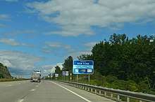
On June 27, 2014, New York Governor Andrew Cuomo announced that the interstate-grade US 15 freeway from the Pennsylvania border to I-86 in Corning was officially signed as I-99.[4]
Future
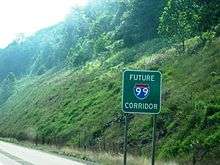
Though there is no specific date for completion, long-term plans call for I-99 to be extended northeastward along US 220 from Bellefonte to Williamsport and northward along US 15 from Williamsport to the New York border. Signs have been erected along the present US 220 and US 15 between Bellefonte and Corning—much of which are built to Interstate Highway standards—marking the route as the "Future I-99 Corridor". Some of this section of road has also received exit number designations. The entirety of US 15 north of Williamsport is a limited-access highway.
Some local Rochester, New York, area supporters have suggested that I-390, which extends north from I-86 24 miles (39 km) west of the I-86/I-99 junction near Corning and which crosses I-90 and terminates in the greater Rochester metro area, be redesignated as I-99 once the I-80 to I-86 portion of that route is completed, positing that it is a logical extension of the I-99 corridor (I-99's predecessor, U.S. Route 15, originally extended to Rochester); no official moves to accomplish this have been forwarded, however.[22]
An extension of I-99 by the Virginia Department of Transportation (VDOT), was under study in Delaware, Maryland, Virginia, North Carolina and South Carolina in the mid-2000s. Such a corridor would follow the U.S. Route 17 (US 17) and US 13 corridors, from Charleston, South Carolina, through the Norfolk–Virginia Beach metro area and across the Chesapeake Bay Bridge-Tunnel complex, up the Delmarva Peninsula to Wilmington, Delaware.[23] If the proposal were to be constructed and approved, it is unclear as to whether it would receive the "I-99" designation.
However, after commissioning a study in 2006, VDOT dismissed the proposal for several reasons. VDOT indicated that expenses in upgrading the Chesapeake Bay tunnels would be about $5 billion. Also cited were the location of new highway alignments, and doubt as to whether other states, particularly South Carolina, would commit to the endeavor.[23] Much of the highway along the corridor would need to be upgraded to Interstate standards, but portions of highway along the corridor have already been upgraded. In the 1990s, Delaware constructed a limited access facility on Delaware Route 1, paralleling US 13 from Dover to Wilmington. Additionally, Delaware has considered upgrading the US 113 corridor south of Dover,[23] though, this deviates from the path suggested by VDOT. In Maryland, a portion of US 13 is routed along a limited-access bypass around Salisbury.
Exit list
| State | County | Location | mi[1][3] | km | Exit | Destinations | Notes |
|---|---|---|---|---|---|---|---|
| Pennsylvania | Bedford | Bedford Township | 0.000 | 0.000 | 1 | Southern end of US 220 concurrency; roadway continues beyond I-70 / I-76 / Penna Turnpike exit 146 (Bedford), as US 220; indirect connection via US 220 Bus. | |
| 2.892 | 4.654 | 3 | |||||
| East St. Clair Township | 6.597 | 10.617 | 7 | Low clearance at exit | |||
| King Township | 10.112 | 16.274 | 10 | Blue Knob State Park | |||
| Blair | Greenfield Township | 14.900 | 23.979 | 15 | Claysburg, King (US 220 Bus. north) | ||
| Freedom Township | 22.798 | 36.690 | 23 | ||||
| Allegheny Township | 28.045 | 45.134 | 28 | ||||
| Logan Township | 30.507 | 49.096 | 31 | Plank Road (US 220 Bus.) | Access to Logan Valley Mall | ||
| 31.803 | 51.182 | 32 | Access to Lakemont Park and Peoples Natural Gas Field | ||||
| 32.921 | 52.981 | 33 | 17th Street | Access to Logan Town Centre | |||
| Antis Township | 38.521 | 61.994 | 39 | Northern terminus of PA 764 | |||
| 41.193 | 66.294 | 41 | Southern terminus of PA 865 | ||||
| 45.004 | 72.427 | 45 | Tipton, Grazierville | Access to DelGrosso's Amusement Park | |||
| Tyrone | 47.529 | 76.491 | 48 | ||||
| Snyder Township | 51.592 | 83.029 | 52 | ||||
| Centre | Worth Township | 61.437 | 98.873 | 61 | Port Matilda (US 220 Alt. north) | ||
| 62.243 | 100.170 | 62 | Southern end of US 322 concurrency; southbound exit and northbound entrance; northbound exit is via exit 61 | ||||
| Patton Township | 68.993 | 111.033 | 68 | Gray's Woods, Waddle | |||
| 69.706 | 112.181 | 69 | Northbound exit and southbound entrance | ||||
| 70.200 | 112.976 | 69 | Valley Vista Drive – Park Forest | Southbound exit and northbound entrance | |||
| 71.122 | 114.460 | 71 | Toftrees, Woodycrest | ||||
| College Township | 73.944 | 119.001 | 73 | Northern end of US 322 concurrency, access to Beaver Stadium and Medlar Field at Lubrano Park | |||
| 75.067 | 120.809 | 74 | Innovation Park, Penn State University | Northbound exit is part of exit 73 | |||
| Benner Township | 76.484 | 123.089 | 76 | Shiloh Road | |||
| 78.991 | 127.124 | 78 | Signed as 78A (south) and 78B (north) | ||||
| Spring Township | 81.232 | 130.730 | 80 | Harrison Road | Northbound exit and southbound entrance | ||
| 81.728 | 131.528 | 81 | Southern end of PA 26 concurrency | ||||
| 83.605 | 134.549 | 83 | |||||
| 85.780 | 138.050 | Township Road T425-4 (Musser Lane) | Northern end of I-99 signage at Musser Lane; southern end Future I-99; roadway continues as US 220 | ||||
| Gap in designation, connection made via I-80, US 220, and US 15 | |||||||
| New York | Steuben | Lindley | 0.00 | 0.00 | Northern terminus of Future I-99; Pennsylvania state line | ||
| 6.36 | 10.24 | 6 | |||||
| Erwin | 8.16 | 13.13 | 8 | ||||
| 11.12 | 17.90 | 11 | |||||
| 11.69 | 18.81 | 12 | Robert Dann Drive (CR 107) | Southbound exit and northbound entrance | |||
| 12.10 | 19.47 | 12 | Northbound exit and southbound entrance; exit 44 on I-86/NY 17 | ||||
| 12.68 | 20.41 | 13A | Northern terminus of US 15; exit 44 on I-86/NY 17 | ||||
| 13.08 | 21.05 | 13B | Northbound exit and southbound entrance | ||||
1.000 mi = 1.609 km; 1.000 km = 0.621 mi
| |||||||
See also

.svg.png)
References
- 1 2 3 Bureau of Maintenance and Operations (January 2015). Roadway Management System Straight Line Diagrams (Report) (2015 ed.). Pennsylvania Department of Transportation. Retrieved June 30, 2015.
- Bedford County (PDF)
- Blair County (PDF)
- Centre County (PDF)
- 1 2 "Report of the Special Committee on U.S. Route Numbering to the Standing Committee on Highways" (PDF). American Association of State Highway and Transportation Officials. November 7, 1998. Archived from the original (PDF) on October 12, 2006. Retrieved July 18, 2010.
- 1 2 "Steuben County Inventory Listing". New York State Department of Transportation. October 1, 2009. Archived from the original (CSV) on April 8, 2013. Retrieved January 17, 2010.
- 1 2 [Staff writer] (June 28, 2014). "Corning Area Now Has 2 Interstates: US 15 Designated I-99 to Pa. Border". Star-Gazette. Archived from the original on July 15, 2014. Retrieved June 28, 2014.
- 1 2 3 4 Google (July 18, 2010). "Overview Map of I-99" (Map). Google Maps. Google. Retrieved July 18, 2010.
- 1 2 Microsoft; Nokia (July 24, 2012). "overview map of Interstate 99 in New York" (Map). Bing Maps. Microsoft. Retrieved July 24, 2012.
- ↑ Yanosey, Robert J. (2006). New York. Erie Railroad Facilities in Color. Volume 2: NY. Lawton, Devon (photographer). Scotch Plains, New Jersey: Morning Sun Books. p. 71. ISBN 1-58248-196-2.
- ↑ "Status of the Appalachian Development Highway System as of September 30, 2009" (PDF). Appalachian Regional Commission. December 2009. Retrieved July 18, 2010.
- ↑ Pennsylvania (Map) (1964–65 ed.). Cartography by H. M. Gousha Company. Sun Oil Company. 1964.
- 1 2 3 Official Map of Pennsylvania (PDF) (Map). Pennsylvania Department of Highways. 1970. Retrieved July 18, 2010.
- 1 2 3 Commonwealth of Pennsylvania Official Transportation Map (PDF) (Map). Pennsylvania Department of Transportation. 1980. Retrieved July 18, 2010.
- ↑ Pennsylvania Official Transportation Map (PDF) (Map). Pennsylvania Department of Transportation. 1989. Retrieved July 18, 2010.
- ↑ Easy-to-Read Travel Atlas: United States–Canada–Mexico (Map). Rand McNally and Company. 1997. p. 44. ISBN 0-528-81575-X.
- ↑ "Bill Summary & Status H.R.2950". Retrieved June 23, 2014.
- ↑ "Bill Text H.R.2950". Retrieved June 23, 2014.
- ↑ "National Highway System Designation Act of 1995". Retrieved June 23, 2014.
- 1 2 3 4 Hamill, Sean D. (December 27, 2008). "Road Stirs Up Debate, Even on Its Name". The New York Times.
- 1 2 3 4 Bock, Greg (November 25, 2008). "Long road for I-99 comes to end". Altoona Mirror. Retrieved July 18, 2010.
- ↑ Gibb, Tom (December 7, 2002). "I-99 segment gets environmental OK". Pittsburgh Post-Gazette. Retrieved July 19, 2010.
- ↑ Bock, Greg (December 18, 2007). "Long-awaited I-99 stretch opens". Altoona Mirror. Retrieved July 19, 2010.
- ↑ "Report of the Special Committee on U.S. Route Numbering to the Standing Committee on Highways" (PDF). American Association of State Highway and Transportation Officials. May 31, 2003. Archived from the original (PDF) on February 4, 2007. Retrieved July 18, 2010.
- ↑ "Interstate 99/US 220/US 15 (Corridor 9)". AARoads. July 27, 2003. Archived from the original on October 24, 2014. Retrieved July 2, 2014.
- 1 2 3 Homer, Pierce R. (November 2006). "Construction of I-99: Appropriation Act Item 427 H. (Special Session I, 2006)" (PDF). Virginia Department of Transportation. Retrieved August 10, 2013.
External links
| Wikimedia Commons has media related to Interstate 99. |
Route map:
- Interstate 99 at New York Routes
- Interstate 99 at Pennsylvania Highways
| Signed | |
|---|---|
| Unsigned | |
| Lists | |
| Other | |
Major Interstates highlighted | |