Lands administrative divisions of Queensland
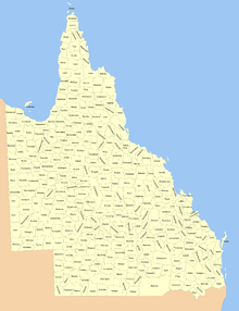
Lands administrative divisions of Queensland refers to the divisions of Queensland used for the registration of land titles. There are 322 counties, and 5,319 parishes within the state.[1] They are part of the Lands administrative divisions of Australia. Queensland had been divided into 109 counties in the nineteenth century, before the Land Act of 1897 subdivided many of these counties to 319. Some of the eastern counties remained the same, with most of the subdivisions occurring in the west and north. The current counties were named and bounded by the Governor in Council on 7 March 1901.[2][3]
In 2006, the government sought advice about a plan to abolish the counties and parishes within the state.[4] From 30 November 2015, the government no longer referenced counties and parishes in land information systems however the Museum of Lands, Mapping and Surveying retains a record for historical purposes.[5]
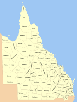
Land districts
Queensland was divided into districts in the mid-nineteenth century. The districts still exist today, forming the top level of Queensland's land titles system.
- Burke (named after Burke and Wills)
- Cook
- Darling Downs
- Leichhardt
- Maranoa
- Mitchell
- Moreton
- North Gregory
- North Kennedy
- Port Curtis
- South Gregory
- South Kennedy
- Warrego
- Wide Bay/Burnett
19th century counties
There were 109 counties in Queensland by the late nineteenth century, before they were subdivided into the current 322 counties. All of these original counties continue to exist but many are smaller than they were in the nineteenth century, with many new counties added. For the counties which were subdivided in 1901, the original county remains, usually around the largest town in the area, but smaller than before. For instance the nineteenth century county of Beaconsfield was based around Cloncurry; Cloncurry is still in Beaconsfield, but the county is much smaller, with new counties such as Argylla, Sellwyn and Alison surrounding it.
List of counties by district
Moreton, Darling Downs and Wide Bay/Burnett Districts
| County | District | Major towns |
|---|---|---|
| Aubigny | Darling Downs | Toowoomba, Dalby |
| Auburn | Darling Downs | |
| Bentinck | Darling Downs | Stanthorpe |
| Boondooma | Wide Bay/Burnett | |
| Bowen | Wide Bay/Burnett | Gin Gin |
| Bulwer | Darling Downs | Miles |
| Canning | Moreton | Caboolture, Sunshine Coast |
| Carnarvon | Darling Downs | |
| Cavendish | Moreton | Esk, Kingaroy |
| Churchill | Moreton | Gatton |
| Clive | Darling Downs | Texas |
| Cook | Wide Bay/Burnett | Bundaberg |
| Derby | Darling Downs | Millmerran |
| Fitzroy | Wide Bay/Burnett | Nanango |
| Fraser | Wide Bay/Burnett | Fraser Island |
| Lennox | Wide Bay/Burnett | Kilkivan |
| Lytton | Darling Downs | Chinchilla |
| Mackenzie | Wide Bay/Burnett | Gayndah, Mundubbera |
| March | Wide Bay/Burnett | Gympie, Hervey Bay, Maryborough, Noosa |
| Marsh | Darling Downs | Goondiwindi |
| Merivale | Darling Downs | Warwick |
| Newcastle | Wide Bay/Burnett | |
| Pring | Darling Downs | |
| Rawbelle | Wide Bay/Burnett | Monto |
| Rogers | Darling Downs | Condamine |
| Stanley | Moreton | Brisbane, Ipswich, Logan, Redcliffe |
| Ward | Moreton | Gold Coast |
| Wicklow | Wide Bay/Burnett | |
| Yarrol | Wide Bay/Burnett | Eidsvold |
Burke District
- Albion
- Allison
- Argylla
- Beaconsfield (including Cloncurry)
- Brahe
- Buller
- Burke
- Canobie
- Carpentaria
- Chudleigh
- Douglas
- Dutton
- Eddington
- Esmeralda
- Fielding
- Glenora
- Granada
- Gregory
- Howitt
- Iffley
- Kamileroi
- Lamington
- Landsborough
- Manfred
- Morstone
- Mueller
- Nash
- Nicholson
- Norman (including Normanton)
- Oaklands
- Parker
- Philp
- Porchester
- Richmond
- Rochedale (including Mount Isa)
- Rupert
- Savannah
- Saxby
- Selwyn
- Stokes
- Surrey
- Talawanta
- Taldora
- Tewinga
- Toorak
- Undilla
- Wellesley (Wellesley Islands)
- Wentworth
- Wondoola
- Wongalee
- Wonomo
- Woolgar
- Yappar
Cook District
- Archer
- Balurga
- Banks (including Cooktown)
- Bolwarra
- Byerley
- Chelmsford
- Coen
- Cootah
- Copperfield
- Dagmar
- Dulhunty
- Dunbar
- Etheridge
- Franklin
- Gilbert (including Georgetown)
- Gould
- Hann
- Hodgkinson
- Jardine
- Kalkah
- Kendall
- King
- Koolatah
- Lang
- Linasleigh
- Lukin
- Lynd
- Lyndhurst
- Maramie
- Marga
- Melville
- Mosman
- Nares (including Cairns)
- Pera
- Percy
- Shelburne
- Sidmouth
- Solander
- Somerset
- Strathleven
- Strathmore
- Tate
- Torres (Torres Strait Islands)
- Victor
- Walsh
- Warner
- Weipa
- Weymouth
- Wrotham
- Yagoonya
- York
Leichhardt District
- Aberdeen
- Bauhinia
- Cairns
- Clermont
- Consuelo
- Dawson
- Denison
- Ferguson
- Fortescue
- Humboldt
- Killarney
- Kimberley
- Labouchere
- Leura
- Plantagenet
- Roper
- Talbot
- Tingarra
- Westgrove
- Wodehouse
- Wooroora
Maranoa District
Mitchell District
- Barcoo
- Cassillis
- Cheviot
- Coorajah
- Coreena
- Cumberland
- Evora
- Fermoy
- Gayundah
- Maneroo
- Mexico
- Mitchell
- Musgrave
- Paluma
- Portland (including Longreach)
- Rodney (including Barcaldine and Aramac)
- Ruthven
- Tambo
- Towerhill
- Uanda
- Ularunda
- Vergemont
- Walker
- Warbreccan
- Windeyer
- Wolseley
- Wooroolah
- Woura
- Youranigh
North Gregory District
- Amaroo
- Ayrshire (including Winton)
- Binburie
- Brighton
- Buckingham
- Carrandotta
- Chatsworth
- Currawilla
- Diamantina
- Elderslie
- Eurinye
- Eyre
- Farrar
- Georgina
- Glengyle
- Hamilton
- Kynuna
- Malwa
- Manuka
- Mayne
- Merlin
- Monkira
- Mowarra
- Nyama
- Oondooroo
- Piturie
- Rosebrook
- Sandringham
- Sturt
- Toko
- Warburton
- Waverley
- Wills
- Windsor
- Wokingham
- Woodstock
North Kennedy District
- Cardwell (including Hinchinbrook Island)
- Clarke
- Dalrymple
- Davenport (including Charters Towers)
- Elphinstone (including Townsville)
- Gladstone
- Griffith
- Gunnawarra
- Herbert (including Bowen and the Whitsunday Islands)
- Murray
- O'Connell
- Salisbury
- Wairuna
- Wilkie Gray
Port Curtis District
- Clinton (including Gladstone)
- Deas Thompson
- Flinders
- Liebig
- Livingstone (including Rockhampton)
- Murchison
- Pakington
- Palmerston
- Pelham
- Raglan
South Gregory District
- Abbotsford
- Bulgroo
- Burarie
- Cameron
- Carruthers
- Conbar
- Cooper
- Curralle
- Daroo
- Durham
- Durrie
- Gordon
- Grey
- Haddon
- Kyabra
- Pender
- Rosebery (including Birdsville)
- Tanbar
- Thunda
- Weramo
- Weringa
- Wilson
- Windula
South Kennedy District
Warrego District
- Bando
- Bulloo
- Burenda
- Burrandilla
- Chesterton
- Glanworth
- Gowan
- Humeburn
- Kungie
- Kyrunda
- Langlo
- McKinlay
- Munga
- Nickavilla
- Nive
- Noorama
- Norley
- Numalla
- Orrery (including Charleville)
- Palmer
- Paroo
- Pitteroo
- Ross
- Titheroo
- Wellington (including Cunnamulla)
- Wyara
References
- ↑ "Cadastral mapping". Queensland Government. Archived from the original on 15 June 2009. Retrieved 22 June 2017.
- ↑ "Kendall - county (entry 17923)". Queensland Place Names. Queensland Government. Retrieved 22 June 2017.
- ↑ Queensland. Survey Office. "Digital Collections - Maps - Queensland. Survey Office. Queensland showing counties". Nla.gov.au. Retrieved 28 May 2012.
- ↑ "900 Years of History to Disappear in Queensland" (Press release). Ipswich City Council. 14 June 2006. Archived from the original (PDF) on 27 September 2007. Retrieved 28 May 2012.
- ↑ "Locality boundaries - Queensland". Department of Natural Resources, Mines and Energy. 27 August 2017. Retrieved 2 October 2018.