County of Wicklow, Queensland
| Wicklow Queensland | |||||||||||||||
|---|---|---|---|---|---|---|---|---|---|---|---|---|---|---|---|
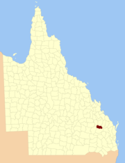 Location within Queensland | |||||||||||||||
| |||||||||||||||
Wicklow County is a county (a cadastral division) in Queensland, Australia, located in the Wide Bay–Burnett region.[1][2] On 7 March 1901, the Governor issued a proclamation legally dividing Queensland into counties under the Land Act 1897.[3] Its schedule described Wicklow thus:
Bounded on the east by the county of Yarrol; on the south by the county of Newcastle; on the west by the eastern watershed of the Dawson River; and on the north by the south boundaries of Knockbreak Lease, Calrossie Resumption, Culcragie Lease, part of Culcragie Resumption, and by the north boundary of Eidsvold Resumption.
Parishes
| Parish | LGA | Coordinates |
|---|---|---|
| Auburn | North Burnett | 25°36′S 151°07′E / 25.600°S 151.117°E |
| Boolgal | North Burnett | 25°27′S 150°55′E / 25.450°S 150.917°E |
| Borania | North Burnett | 25°22′S 150°30′E / 25.367°S 150.500°E |
| Cheltenham | North Burnett | 25°34′S 150°49′E / 25.567°S 150.817°E |
| Cloncose | North Burnett | 25°23′S 150°38′E / 25.383°S 150.633°E |
| Dykehead | North Burnett | 25°37′S 151°00′E / 25.617°S 151.000°E |
| Dyngie | North Burnett | 25°28′S 150°31′E / 25.467°S 150.517°E |
| Eidsvold | North Burnett | 25°27′S 151°03′E / 25.450°S 151.050°E |
| Narayen | North Burnett | 25°39′S 150°51′E / 25.650°S 150.850°E |
| Redbank | North Burnett | 25°36′S 150°41′E / 25.600°S 150.683°E |
| Woodbank | North Burnett | 25°35′S 150°30′E / 25.583°S 150.500°E |
| Yerilla | North Burnett | 25°24′S 150°48′E / 25.400°S 150.800°E |
References
- ↑ "Wicklow (entry 37408)". Queensland Place Names. Queensland Government. Retrieved 2 September 2015.
- ↑ Wide Bay/Burnett District, County of Wicklow Maps – E2 Series at Queensland Archives.
- ↑ "A Proclamation". Queensland Government Gazette. 75. 8 March 1901. pp. 967–980.
Coordinates: 25°47′S 150°49′E / 25.783°S 150.817°E
This article is issued from
Wikipedia.
The text is licensed under Creative Commons - Attribution - Sharealike.
Additional terms may apply for the media files.