County of Fitzroy, Queensland

Fitzroy
Queensland
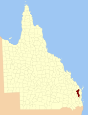
Location within Queensland
Lands administrative divisions around Fitzroy:
Mackenzie Mackenzie Lennox
Boondooma Fitzroy Canning
Aubigny Cavendish Cavendish

The County of Fitzroy is a county (a cadastral division) in Queensland, Australia.[1] Like all counties in Queensland, it is a non-functional administrative unit, that is used mainly for the purpose of registering land titles.

Fitzroy includes the eastern and central parts of the South Burnett Region and part of the former Shire of Kilkivan in the Gympie Region.[2] It was named by the Surveyor-General of New South Wales in the 1850s after Charles Augustus FitzRoy, who served as the Governor of New South Wales from 1848 to 1855. The county was officially named and bounded by the Governor in Council on 7 March 1901 under the Land Act 1897.[1] The county is unrelated to the Fitzroy River, which is centred on the County of Livingstone.

Parishes

Fitzroy is divided into parishes, as listed below:

ParishLGACoordinatesTowns
BarambahSouth Burnett26°19′S 152°05′E / 26.317°S 152.083°E / -26.317; 152.083 (Barambah Parish)Moffatdale
BooieSouth Burnett26°32′S 152°00′E / 26.533°S 152.000°E / -26.533; 152.000 (Booie Parish)
BoonenneSouth Burnett26°35′S 151°44′E / 26.583°S 151.733°E / -26.583; 151.733 (Boonenne Parish)Kingaroy, Inverlaw
CharlestownSouth Burnett26°25′S 151°56′E / 26.417°S 151.933°E / -26.417; 151.933 (Charlestown Parish)
CherbourgSouth Burnett26°19′S 151°56′E / 26.317°S 151.933°E / -26.317; 151.933 (Cherbourg Parish)Cherbourg
CloynaSouth Burnett26°08′S 151°53′E / 26.133°S 151.883°E / -26.133; 151.883 (Cloyna Parish)Cloyna
CoolabuniaSouth Burnett26°37′S 151°59′E / 26.617°S 151.983°E / -26.617; 151.983 (Coolabunia Parish)Coolabunia
GallangowanGympie26°27′S 152°17′E / 26.450°S 152.283°E / -26.450; 152.283 (Gallangowan Parish)
GoomeribongGympie26°12′S 152°04′E / 26.200°S 152.067°E / -26.200; 152.067 (Goomeribong Parish)Goomeri
HalySouth Burnett26°46′S 151°37′E / 26.767°S 151.617°E / -26.767; 151.617 (Haly Parish)
JohnstownSouth Burnett26°25′S 152°06′E / 26.417°S 152.100°E / -26.417; 152.100 (Johnstown Parish)
KunioonSouth Burnett26°41′S 151°52′E / 26.683°S 151.867°E / -26.683; 151.867 (Kunioon Parish)Goodger
ManumbarGympie26°22′S 152°18′E / 26.367°S 152.300°E / -26.367; 152.300 (Manumbar Parish)Manumbar
McEuenSouth Burnett26°18′S 151°50′E / 26.300°S 151.833°E / -26.300; 151.833 (McEuen Parish)Wondai, Tingoora
MondureSouth Burnett26°12′S 151°45′E / 26.200°S 151.750°E / -26.200; 151.750 (Mondure Parish)Hivesville
MurgonSouth Burnett26°13′S 151°55′E / 26.217°S 151.917°E / -26.217; 151.917 (Murgon Parish)Murgon
NanangoSouth Burnett26°41′S 151°59′E / 26.683°S 151.983°E / -26.683; 151.983 (Nanango Parish)Nanango
NeumgnaSouth Burnett26°53′S 151°48′E / 26.883°S 151.800°E / -26.883; 151.800 (Neumgna Parish)
TaabingaSouth Burnett26°41′S 151°42′E / 26.683°S 151.700°E / -26.683; 151.700 (Taabinga Parish)Kumbia
TarongSouth Burnett26°47′S 151°50′E / 26.783°S 151.833°E / -26.783; 151.833 (Tarong Parish)Brooklands
TureenSouth Burnett26°50′S 151°40′E / 26.833°S 151.667°E / -26.833; 151.667 (Tureen Parish)
WooroolinSouth Burnett26°28′S 151°46′E / 26.467°S 151.767°E / -26.467; 151.767 (Wooroolin Parish)Kingaroy, Wooroolin

References

  1. 1 2 "Fitzroy (entry 12560)". Queensland Place Names. Queensland Government. Retrieved 1 September 2015.
  2. Wide Bay/Burnett District, County of Fitzroy Maps - D4 Series at Queensland Archives.

Coordinates: 26°40′S 152°00′E / 26.667°S 152.000°E / -26.667; 152.000


This article is issued from Wikipedia. The text is licensed under Creative Commons - Attribution - Sharealike. Additional terms may apply for the media files.