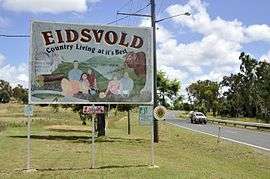
Eidsvold, Queensland
| Eidsvold Queensland | |||||||||||||||
|---|---|---|---|---|---|---|---|---|---|---|---|---|---|---|---|
 Eidsvold, 2011 | |||||||||||||||
 Eidsvold | |||||||||||||||
| Coordinates | 25°22′0″S 151°08′0″E / 25.36667°S 151.13333°ECoordinates: 25°22′0″S 151°08′0″E / 25.36667°S 151.13333°E | ||||||||||||||
| Population | 630 (2011 census)[1] | ||||||||||||||
| Postcode(s) | 4627 | ||||||||||||||
| Location |
| ||||||||||||||
| LGA(s) | North Burnett Region | ||||||||||||||
| State electorate(s) | Callide | ||||||||||||||
| Federal Division(s) | Flynn | ||||||||||||||
| |||||||||||||||
Eidsvold (/ˈaɪdzvoʊld/) is a small town and locality in the North Burnett Region of Queensland, Australia.[2][3] The town is the self-proclaimed Beef Capital of the Burnett and is a hub for the regional cattle industry. In the 2011 census, Eidsvold had a population of 630 people.[1]
Geography
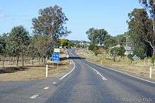
Eidsvold is situated on the Burnett Highway approximately 430 kilometres (270 mi) north of the state capital, Brisbane. The highway passes through the locality from the south-east to the north-east, passing through the town's main street (Moreton Street). The Mungar Junction to Monto branch railway passes from south-east to north-east through the locality, roughly parallel to the highway; the Eidsvold railway station serves the town.[4]
History
The town is named for Eidsvold Station, a nearby property, that is named for Eidsvoll, Norway (using the pre-1918 spelling) where the Norwegian Constitution was signed in 1814.[2] The station was given this name by the Archer brothers, Scottish settlers who also had land holdings in Norway. The Eidsvold run was licensed to Thomas Archer in June 1848. The Town Reserve, 3 miles (4.8 km) east of the station homestead, was proclaimed 19 March 1890, and the post office opened 19 September 1887.[5]
At the 2006 census, Eidsvold had a population of 459.[6]
Heritage listings
Eidsvold has a number of heritage-listed sites, including:
- Eidsvold Road: Eidsvold Homestead[7]
Facilities
Eidsvold has an R. M. Williams Australian bush learning centre, historical museum and complex, swimming pool, showground and bowling and golf clubs.
The North Burnett Regional Council operate a public library at 36 Moreton Street.[8]
The historical museum pays tribute to the 62 soldiers from the Eidsvold area that served in the First World War. Displays include photographs, medals and the Shire of Eidsvold Honour Board.[9]
Notable residents
- David and Thomas Archer, pioneer settlers
- Jim Burrows, Member of the Queensland Legislative Assembly
- Percy Byrnes, Member of the Victorian Legislative Council
- David Farrell, Member of the Queensland Legislative Assembly
- George Farrell, Member of the Queensland Legislative Assembly
- George Halford, Anglican bush brother and bishop of Rockhampton
- Lindsay Hartwig, David Farrell (politician)
- Nev Hewitt, Member of the Queensland Legislative Assembly
- William Forster McCord, Member of the Queensland Legislative Assembly
- Lloyd McDermott, Australia's first indigenous barrister and Australian rugby union player
- Maureen Watson, Indigenous activist
- R. M. Williams, bushman and entrepreneur
Gallery
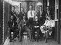 Eidsvold Shire Council members, ca. 1908
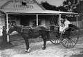 George Beck's store and bakery, ca 1910
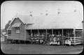 Eidsvold State School and students, 1912
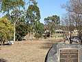 Eidsvold Centenary Gardens, Commemorating the Centenary of the Eidsvold Goldfields. Taken 18 Sept 2018
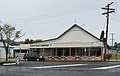 Eidsvold Public Library, 22 November 2017
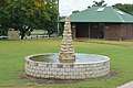 Fountain at Eidsvold, Queensland. 22 November 2017
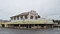 Eidsvold Bakery, no longer operating. 22 November 2017
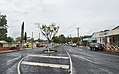 Moreton Street, the Burnett Highway, at Eidsvold, Queensland. 22 November 2017
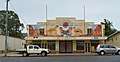 Munjoorum building at Eidsvold, Queensland. 22 November 2017
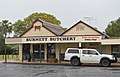 Butcher shop at Eidsvold, Queensland. 22 November 2017
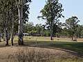 A view across the golf course, Eidsvold, Queensland, Australia. 18 September 2018
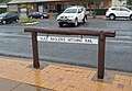 Alice Maslen's Hitching Rail at Eidsvold, Queensland. 22 November 2017
References
- 1 2 Australian Bureau of Statistics (31 October 2012). "Eidsvold (SSC)". 2011 Census QuickStats. Retrieved 21 August 2016.

- 1 2 "Eidsvold - town (entry 11282)". Queensland Place Names. Queensland Government. Retrieved 20 August 2016.
- ↑ "Eidsvold - locality (entry 45346)". Queensland Place Names. Queensland Government. Retrieved 20 August 2016.
- ↑ "Queensland Globe". State of Queensland. Archived from the original on 30 March 2017. Retrieved 21 August 2016.
- ↑ Frew, Joan (1981) Queensland Post Offices 1842-1980 and Receiving Offices 1869-1927, p. 263. Fortitude Valley, Queensland: published by the author, ISBN 0-9593973-0-2
- ↑ Australian Bureau of Statistics (25 October 2007). "Eidsvold (L) (Urban Centre/Locality)". 2006 Census QuickStats. Retrieved 25 October 2007.
- ↑ "Eidsvold Homestead (entry 600489)". Queensland Heritage Register. Queensland Heritage Council. Retrieved 12 July 2013.
- ↑ "Library Services". Gympie Regional Council. Archived from the original on 31 January 2018. Retrieved 31 January 2018.
- ↑ Every, Niles (14 December 2017). "Eidsvold's soldiers". Queensland's World War 1 Centenary Blog. State Library of Queensland. Archived from the original on 17 April 2018. Retrieved 16 April 2018.
External links
![]()