County of Newcastle, Queensland

Newcastle
Queensland
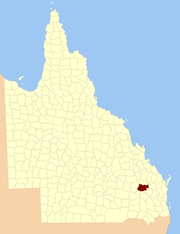
Location within Queensland
Lands administrative divisions around Newcastle:
Fortescue Wicklow Bowen
Fortescue Newcastle Mackenzie
Auburn Auburn Boondooma

The County of Newcastle is a county (a cadastral division) in the Wide Bay–Burnett region of Queensland, Australia.[1][2] On 7 March 1901, the Governor issued a proclamation legally dividing Queensland into counties under the Land Act 1897.[3] Its schedule described Newcastle thus:

Bounded on the east by the counties of Mackenzie and Boondooma; on the south by the Main Dividing Range; on the west by the eastern watershed of the Dawson River; on the north by the northern boundaries of the leased parts of Auburn and Hawkwood Runs and the Auburn River from the confluence of Narayen Creek downwards to its junction with the Burnett River.

Parishes

Newcastle is divided into parishes, as listed below:

ParishLGACoordinates
BallymoreWestern Downs25°44′S 150°30′E / 25.733°S 150.500°E / -25.733; 150.500 (Ballymore Parish)
BeeronNorth Burnett25°57′S 151°16′E / 25.950°S 151.267°E / -25.950; 151.267 (Beeron Parish)
BroviniaNorth Burnett25°54′S 151°07′E / 25.900°S 151.117°E / -25.900; 151.117 (Brovinia Parish)
CadargaWestern Downs26°07′S 151°02′E / 26.117°S 151.033°E / -26.117; 151.033 (Cadarga Parish)
ChessboroughNorth Burnett25°47′S 151°07′E / 25.783°S 151.117°E / -25.783; 151.117 (Chessborough Parish)
CoondarraWestern Downs26°13′S 150°38′E / 26.217°S 150.633°E / -26.217; 150.633 (Coondarra Parish)
CurriesideNorth Burnett25°56′S 150°56′E / 25.933°S 150.933°E / -25.933; 150.933 (Currieside Parish)
DelembraNorth Burnett25°46′S 150°59′E / 25.767°S 150.983°E / -25.767; 150.983 (Delembra Parish)
DerraNorth Burnett25°43′S 151°15′E / 25.717°S 151.250°E / -25.717; 151.250 (Derra Parish)
GoldsmithWestern Downs26°09′S 150°26′E / 26.150°S 150.433°E / -26.150; 150.433 (Goldsmith Parish)
HalloranNorth Burnett25°46′S 150°45′E / 25.767°S 150.750°E / -25.767; 150.750 (Halloran Parish)
HawkwoodNorth Burnett25°51′S 150°52′E / 25.850°S 150.867°E / -25.850; 150.867 (Hawkwood Parish)
JarrahWestern Downs26°12′S 150°50′E / 26.200°S 150.833°E / -26.200; 150.833 (Jarrah Parish)
KilbegganWestern Downs25°54′S 150°29′E / 25.900°S 150.483°E / -25.900; 150.483 (Kilbeggan Parish)
KokoNorth Burnett25°59′S 150°49′E / 25.983°S 150.817°E / -25.983; 150.817 (Koko Parish)
KragraWestern Downs26°07′S 150°51′E / 26.117°S 150.850°E / -26.117; 150.850 (Kragra Parish)
MaclarenWestern Downs26°03′S 150°33′E / 26.050°S 150.550°E / -26.050; 150.550 (Maclaren Parish)
MonogorilbyNorth Burnett26°01′S 151°04′E / 26.017°S 151.067°E / -26.017; 151.067 (Monogorilby Parish)
MoonboonburyNorth Burnett25°49′S 151°15′E / 25.817°S 151.250°E / -25.817; 151.250 (Moonboonbury Parish)
RoscommonWestern Downs26°04′S 150°42′E / 26.067°S 150.700°E / -26.067; 150.700 (Roscommon Parish)
RosehallWestern Downs25°52′S 150°40′E / 25.867°S 150.667°E / -25.867; 150.667 (Rosehall Parish)
SujeewongWestern Downs25°42′S 150°36′E / 25.700°S 150.600°E / -25.700; 150.600 (Sujeewong Parish)
WarrannaWestern Downs26°01′S 150°24′E / 26.017°S 150.400°E / -26.017; 150.400 (Warranna Parish)

References

  1. "Newcastle (entry 24151)". Queensland Place Names. Queensland Government. Retrieved 8 September 2015.
  2. Wide Bay/Burnett Districts, County of Newcastle Maps – D9 Series at Queensland Archives.
  3. "A Proclamation". Queensland Government Gazette. 75. 8 March 1901. pp. 967–980.

Coordinates: 25°47′S 150°49′E / 25.783°S 150.817°E / -25.783; 150.817


This article is issued from Wikipedia. The text is licensed under Creative Commons - Attribution - Sharealike. Additional terms may apply for the media files.