County of Ward, Queensland

Ward
Queensland
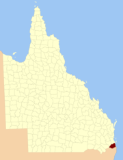
Location within Queensland
Lands administrative divisions around Ward:
Churchill Stanley Pacific Ocean
Merivale Ward Pacific Ocean
Buller (NSW) Rous (NSW) Pacific Ocean

The County of Ward is a county (a cadastral division) in the south-eastern corner of Queensland, Australia.[1] The main urban area within the county is the city of the Gold Coast, and it also extends to include the southern parts of the West Moreton region centred on Beaudesert and Boonah.[1][2]

History

Ward was first created by an Order in Council by the Governor of New South Wales on 30 December 1848.[3] It was then described in the following terms:

County of Ward, containing about 1105 square miles. Bounded on the south by the range which runs from Point Danger to Mount Lindesay, and thence to Wilsons Peak on the Great Dividing Range; on the north-west by the range which divides the waters of the Teviot from those of the Bremer, until it meets the 28th parallel of south latitude; on the north by that parallel; and on the east by the sea-coast to Point Danger.

The Stanley–Ward boundary was somewhat imprecise — the 28th parallel met the sea near Southport, but gazettals and newspaper reports in the Moreton Bay Courier of land sales in the 1850s noted land between the Logan and Albert rivers as being within Ward, and numerous reports from 1863 onwards identified Boyd, Moffatt and Logan parishes to be part of Ward.

Upon the separation of Queensland from New South Wales in 1859, the southern boundary of Ward became part of the southern boundary of the new colony. On 7 March 1901, the Governor of Queensland proclaimed new boundaries under the Land Act 1897,[4] which were described as follows:

Commencing at Point Danger, and bounded thence on the south by the southern boundary of the State; on the west by the western boundaries of the parishes of Alford, Coochin and Dugandan; on the north by Woollaman Creek and the Logan River; and on the east by Moreton Bay, the Broadwater and the Pacific Ocean.

Parishes

Like all counties in Queensland, Ward is divided into parishes. The parishes current LGA and mapping coordinates to the approximate centre of each location is as follows:

ParishLGACoordinatesTowns
AlbertGold Coast27°46′S 153°18′E / 27.767°S 153.300°E / -27.767; 153.300 (Albert Parish)Alberton, Ormeau (East), Woongoolba
AlfordScenic Rim28°11′S 152°33′E / 28.183°S 152.550°E / -28.183; 152.550 (Alford Parish)
BarrowGold Coast27°56′S 153°20′E / 27.933°S 153.333°E / -27.933; 153.333 (Barrow Parish)Paradise Point, Oxenford
BeaudesertScenic Rim28°03′S 152°59′E / 28.050°S 152.983°E / -28.050; 152.983 (Beaudesert Parish)Beaudesert, Laravale
BoonnahbahGold Coast27°46′S 153°24′E / 27.767°S 153.400°E / -27.767; 153.400 (Boonnahbah Parish)
BoydLogan27°44′S 153°11′E / 27.733°S 153.183°E / -27.733; 153.183 (Boyd Parish)Beenleigh, Bethania, Windaroo
BromeltonScenic Rim27°59′S 152°53′E / 27.983°S 152.883°E / -27.983; 152.883 (Bromelton Parish)Bromelton
CedarGold Coast27°56′S 153°15′E / 27.933°S 153.250°E / -27.933; 153.250 (Cedar Parish)Tamborine Mountain, Upper Coomera
CoochinScenic Rim28°06′S 152°38′E / 28.100°S 152.633°E / -28.100; 152.633 (Coochin Parish)Boonah, Mount Alford
CoomeraGold Coast27°52′S 153°21′E / 27.867°S 153.350°E / -27.867; 153.350 (Coomera Parish)Coomera
CurrigeeGold Coast27°50′S 153°26′E / 27.833°S 153.433°E / -27.833; 153.433 (Currigee Parish)South Stradbroke Island
DarlingtonGold Coast27°48′S 153°12′E / 27.800°S 153.200°E / -27.800; 153.200 (Darlington Parish)Ormeau (West)
DugandanScenic Rim27°56′S 152°47′E / 27.933°S 152.783°E / -27.933; 152.783 (Dugandan Parish)
GilstonGold Coast28°04′S 153°21′E / 28.067°S 153.350°E / -28.067; 153.350 (Gilston Parish)Broadbeach, Burleigh Heads
JimboombaLogan27°51′S 153°02′E / 27.850°S 153.033°E / -27.850; 153.033 (Jimboomba Parish)Jimboomba
KerryScenic Rim28°09′S 153°04′E / 28.150°S 153.067°E / -28.150; 153.067 (Kerry Parish)Kerry
KnappScenic Rim28°08′S 152°48′E / 28.133°S 152.800°E / -28.133; 152.800 (Knapp Parish)Rathdowney
LoganLogan27°54′S 153°00′E / 27.900°S 153.000°E / -27.900; 153.000 (Logan Parish)Woodhill
MelcombeScenic Rim28°14′S 152°38′E / 28.233°S 152.633°E / -28.233; 152.633 (Melcombe Parish)
MoffattLogan27°47′S 153°06′E / 27.783°S 153.100°E / -27.783; 153.100 (Moffatt Parish)Logan Village, Waterford
MudgeerabaGold Coast28°08′S 153°22′E / 28.133°S 153.367°E / -28.133; 153.367 (Mudgeeraba Parish)Mudgeeraba
MundoolunLogan27°54′S 153°04′E / 27.900°S 153.067°E / -27.900; 153.067 (Mundoolun Parish)Mundoolun
NerangGold Coast27°59′S 153°22′E / 27.983°S 153.367°E / -27.983; 153.367 (Nerang Parish)Nerang, Southport, Carrara
NindooinbahScenic Rim28°03′S 153°04′E / 28.050°S 153.067°E / -28.050; 153.067 (Nindooinbah Parish)
NuminbahGold Coast28°11′S 153°15′E / 28.183°S 153.250°E / -28.183; 153.250 (Numinbah Parish)Numinbah Valley, Springbrook
PalenScenic Rim28°16′S 152°46′E / 28.267°S 152.767°E / -28.267; 152.767 (Palen Parish)
PimpamaGold Coast27°49′S 153°18′E / 27.817°S 153.300°E / -27.817; 153.300 (Pimpama Parish)Pimpama
RobertsScenic Rim28°14′S 153°08′E / 28.233°S 153.133°E / -28.233; 153.133 (Roberts Parish)
SarabahScenic Rim28°06′S 153°07′E / 28.100°S 153.117°E / -28.100; 153.117 (Sarabah Parish)
TabragalbaScenic Rim27°59′S 153°07′E / 27.983°S 153.117°E / -27.983; 153.117 (Tabragalba Parish)Canungra
TallebudgeraGold Coast28°10′S 153°26′E / 28.167°S 153.433°E / -28.167; 153.433 (Tallebudgera Parish)Palm Beach, Coolangatta
TamborineScenic Rim27°55′S 153°09′E / 27.917°S 153.150°E / -27.917; 153.150 (Tamborine Parish)Tamborine
TamrookumScenic Rim28°04′S 152°49′E / 28.067°S 152.817°E / -28.067; 152.817 (Tamrookum Parish)Tamrookum
TelemonScenic Rim28°14′S 152°58′E / 28.233°S 152.967°E / -28.233; 152.967 (Telemon Parish)
TeviotScenic Rim27°53′S 152°56′E / 27.883°S 152.933°E / -27.883; 152.933 (Teviot Parish)
WickhamLogan27°49′S 153°09′E / 27.817°S 153.150°E / -27.817; 153.150 (Wickham Parish)
WitherenScenic Rim28°04′S 153°11′E / 28.067°S 153.183°E / -28.067; 153.183 (Witheren Parish)Beechmont, Witheren

See also

References

  1. 1 2 "Ward - county (entry 36511)". Queensland Place Names. Queensland Government. Retrieved 1 September 2015.
  2. Moreton District, County of Ward Maps - A5 Series at Queensland Archives.
  3. "The New Counties". The Moreton Bay Courier. Brisbane: National Library of Australia. 13 January 1849. p. 4. Retrieved 19 June 2013.
  4. "A Proclamation". Queensland Government Gazette. 75. 8 March 1901. pp. 967–980.

Coordinates: 27°55′S 153°10′E / 27.917°S 153.167°E / -27.917; 153.167

This article is issued from Wikipedia. The text is licensed under Creative Commons - Attribution - Sharealike. Additional terms may apply for the media files.