County of Plantagenet, Queensland

Plantagenet
Queensland
Location within Queensland
Lands administrative divisions around Plantagenet:
Belyando Clermont Clermont
Drummond Plantagenet Denison
Claude Buckland Buckland

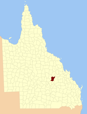
The County of Plantagenet is one of the lands administrative divisions of Queensland that has existed since 1901. It is located in the Central Highlands Region of Central Queensland.[1]

Parishes

It contains the following parishes:

ParishLGACoordinatesTowns
AnakieCentral Highlands23°30′S 147°51′E / 23.500°S 147.850°E / -23.500; 147.850 (Anakie Parish)Anakie
ArgyllCentral Highlands23°28′S 147°26′E / 23.467°S 147.433°E / -23.467; 147.433 (Argyll Parish)
DucabrookCentral Highlands23°55′S 147°20′E / 23.917°S 147.333°E / -23.917; 147.333 (Ducabrook Parish)
DunstableCentral Highlands24°03′S 147°38′E / 24.050°S 147.633°E / -24.050; 147.633 (Dunstable Parish)
Echo HillsCentral Highlands24°03′S 147°26′E / 24.050°S 147.433°E / -24.050; 147.433 (Echo Hills Parish)
GlendarriwellCentral Highlands23°36′S 147°50′E / 23.600°S 147.833°E / -23.600; 147.833 (Glendarriwell Parish)
KilsythCentral Highlands24°03′S 147°15′E / 24.050°S 147.250°E / -24.050; 147.250 (Kilsyth Parish)
MaalandCentral Highlands24°09′S 147°09′E / 24.150°S 147.150°E / -24.150; 147.150 (Maaland Parish)
MedwayCentral Highlands23°48′S 147°20′E / 23.800°S 147.333°E / -23.800; 147.333 (Medway Parish)
NarcissusCentral Highlands24°09′S 147°23′E / 24.150°S 147.383°E / -24.150; 147.383 (Narcissus Parish)
RaymondCentral Highlands24°09′S 147°37′E / 24.150°S 147.617°E / -24.150; 147.617 (Raymond Parish)
RiddellCentral Highlands23°43′S 147°47′E / 23.717°S 147.783°E / -23.717; 147.783 (Riddell Parish)
RutlandCentral Highlands23°53′S 147°41′E / 23.883°S 147.683°E / -23.883; 147.683 (Rutland Parish)
SouthernwoodCentral Highlands23°39′S 147°42′E / 23.650°S 147.700°E / -23.650; 147.700 (Southernwood Parish)
TresswellCentral Highlands24°14′S 147°30′E / 24.233°S 147.500°E / -24.233; 147.500 (Tresswell Parish)
WilfordCentral Highlands23°50′S 147°33′E / 23.833°S 147.550°E / -23.833; 147.550 (Wilford Parish)
WithersfieldCentral Highlands23°35′S 147°30′E / 23.583°S 147.500°E / -23.583; 147.500 (Withersfield Parish)
WoodbineCentral Highlands23°42′S 147°28′E / 23.700°S 147.467°E / -23.700; 147.467 (Woodbine Parish)
ZamiaCentral Highlands23°37′S 147°18′E / 23.617°S 147.300°E / -23.617; 147.300 (Zamia Parish)Bogantungan

References

Coordinates: 23°34′S 147°35′E / 23.567°S 147.583°E / -23.567; 147.583


This article is issued from Wikipedia. The text is licensed under Creative Commons - Attribution - Sharealike. Additional terms may apply for the media files.