Whitsunday Islands
 | |
 | |
| Geography | |
|---|---|
| Location | Queensland, Australia |
| Coordinates | 20°18′S 148°56′E / 20.300°S 148.933°E |
| Total islands | 74 |
| Major islands | Hamilton Island |
| Area | 282.82 km2 (109.20 sq mi) |
| Administration | |
|
Australia | |
| State | Queensland |
| Largest settlement | Hamilton Island (pop. 1350) |
| Demographics | |
| Population | 1,570 (2014) |
| Pop. density | 5.551 /km2 (14.377 /sq mi) |
The Whitsunday Islands is a collection of continental islands of various sizes off the central coast of Queensland, Australia, approximately 900 kilometres (560 miles) north of Brisbane. The northernmost of the islands are situated off the coast by the town of Bowen while the southernmost islands are off the coast by Proserpine. The island group is centered on Whitsunday Island, while the group's commercial center is Hamilton Island. The traditional owners of the area are the Ngaro people and the Gia people (Birri Gubba language group) whose Juru Clan has the only legally recognized native title in the region.[1]
In 2009 as part of the Q150 celebrations, the Whitsunday Islands was announced as one of the Q150 Icons of Queensland for its role as a "Natural attraction".[2]
Naming
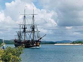
The term is a misnomer as it is based on Captain Cook’s date for the naming of Whitsunday Passage, or as Cook spelled it in his HMS Endeavour journal, Whitsunday’s Passage.[3] Based on his journal date, Cook believed that the passage was discovered on Whitsunday, the Sunday of the feast of Whitsun—Pentecost in the Christian liturgical year—which is observed 7 weeks after Easter. As the International Date Line had not yet been established, the day of discovery was actually Whit Monday.

There is some contention as to exactly which islands are within the informally named Whitsunday Islands, in particular those at the southern extremity and the inclusions to the west. What is certain is that they lie within the chain named Cumberland Isles by Captain Cook (now officially the Cumberland Islands) and a reasonably defined section of that chain and surrounding waters have become known worldwide as The Whitsundays, based on a contraction of the Whitsunday Islands designation.
Tourism
The Whitsunday islands are a popular tourist destination for travelers to Queensland and the Great Barrier Reef with the area being one of the most popular yachting destinations in the Southern Hemisphere. The islands received about 700,000 visitors between March 2008 and March 2009.[4]
The Ngaro Sea Trail Great Walk is a mix of seaways and short walks, crossing South Molle, Hook and Whitsunday islands.[5] The tracks across the islands are linked by seaways suited to kayaking, sailing or powerboating. Camping is available at eight camping areas on the three islands. Several islands have large resorts, offering a wide variety of accommodation and activities. Chartering a yacht or bareboating is a popular way to explore the seaways, beaches and coves.
Components
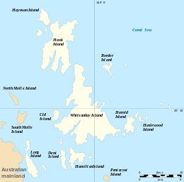
There are a total of 74 islands and islets among all the groups in the Whitsundays.
Whitsunday group
The most notable islands in the main Whitsunday group are named Dent, Hamilton, Hayman, Hook and Whitsunday which features the white sands of Whitehaven Beach.
Lindeman group
The most notable island in the Lindeman group is its namesake Lindeman Island.
Molle group
The most notable islands in the Molle group are Daydream Island (formerly West Molle Island), Long Island and South Molle Island.
Northern group
Some of the islands in the Northern group are Armit, Gloucester and Saddleback.
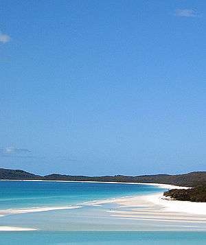 Whitehaven Beach on Whitsunday Island
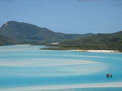 Hill inlet, north of Whitehaven Beach
 Panoramic view of the Whitsunday Islands
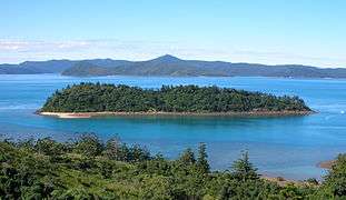 Planton Island
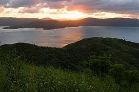 Sunset over mainland from summit of South Molle Island's Mount Jeffreys
Table of islands
Listed below are islands of The Whitsundays, divided by group locality. Named rocks and islets can be found listed within the entry for the nearest island to that feature.
| Island | Capital | Adjacent islets and features | Area (km²) | Population |
|---|---|---|---|---|
| Lindeman Islands | Lindeman Island | 30.34 | 10 | |
| Baynham Island | 0.074 | 0 | ||
| Comston Island | 0.236 | 0 | ||
| Gaibirra Island | 0.323 | 0 | ||
| Keyser Island | 0.577 | 0 | ||
| Lindeman Island | 6.789 | 10 | ||
| Little Lindeman Island | 0.49 | 0 | ||
| Maher Island | Jesus Point | 0.94 | 0 | |
| Mansell Island | 1.177 | 0 | ||
| Other | Ann Island, Cole Island | 0.222 | 0 | |
| Pentecost Island | 1.25 | 0 | ||
| Seaforth Island | North Beach | 0.265 | 0 | |
| Shaw Island | Neck Bay, Burning Point | 15.62 | 0 | |
| Thomas Island | Thomas Bay, Dead Dog Point | 2.23 | 0 | |
| Triangle Island | 0.115 | 0 | ||
| Volskow Island | 0.032 | 0 | ||
| Molle Islands | South Molle Island | 20.17 | 150 | |
| Daydream Island | Coral Beach, Lovers Beach, Mermaids Beach, Sunset Beach | 0.23 | 30 | |
| Denman Island | 0.095 | 0 | ||
| Goat Island | 0.047 | 0 | ||
| Long Island | Base Point, Fire Point, Happy Bay, Paradise Bay, Pelican Beach, Peppers Palm Bay, Sandy Bay, Spit Point | 10.6 | 80 | |
| Mid Molle Island | 0.13 | 0 | ||
| North Molle Island | 2.643 | 0 | ||
| Other | Gunn Island, Repair Island, Shute Island, Tancerd Island | 0.588 | 0 | |
| Pine Island | 1.063 | 0 | ||
| Planton Island | 0.114 | 0 | ||
| South Molle Island | Bauer Bay | 4.66 | 40 | |
| Northern Group | Gloucester Island | 33.56 | 1 | |
| Armit Island | 1.05 | 0 | ||
| Double Cone Island | 0.4 | 0 | ||
| Eshelby Island | 0.13 | 0 | ||
| Gloucester Island | 26.8 | 0 | ||
| Grassy Island | 1.29 | 0 | ||
| Gumbrell Island | 0.47 | 0 | ||
| Manta Ray Island | 0.32 | 0 | ||
| Middle Island | 0.43 | 0 | ||
| Olden Island | 0.43 | 0 | ||
| Poole Island | 0.19 | 0 | ||
| Rattray Island | 0.23 | 0 | ||
| Saddleback Island | 0.58 | 0 | ||
| Stone Island | 1.24 | 1 | ||
| The Whitsunday Group | Hamilton Island | 198.75 | 1409 | |
| Bird Island | 0.017 | 0 | ||
| Black Island | 0.05 | 0 | ||
| Border Island | Cateran Bay | 3.066 | 0 | |
| Cid Island | Bench Point, Gilling Point | 2.95 | 0 | |
| Cowrie Island | 0.024 | 0 | ||
| Deloraine Island | 0.172 | 0 | ||
| Dent Island | 4.13 | 2 | ||
| Dumbell Island | 0.141 | 0 | ||
| Dungarra Island | 0.094 | 0 | ||
| Esk Island | 0.1 | 0 | ||
| Fitzalan Island | 0.054 | 0 | ||
| Hamilton Island | Crab Bay, South Head, Driftwood Bay, Coral Cove, Escape Beach, Broken Point, Sunrise Bay, Hideaway Bay, Catseye Bay, Pebble Beach, Airport Beach | 7.98 | 1350 | |
| Harold Island | 0.345 | 0 | ||
| Haslewood Island | 7.941 | 0 | ||
| Hayman Island | Dolphin Point, Tower Point, Rescue Beach, Groper Point, Arkhurst Point, Blue Pearl Bay, Royal Hayman Hotel | 3.78 | 50 | |
| Henning Island | 0.496 | 0 | ||
| Hook Island | 54.87 | 5 | ||
| Ireby Island | 0.046 | 0 | ||
| Langford Island | 0.093 | 0 | ||
| Lupton Island | 1.05 | 0 | ||
| Nicolson Island | 0.163 | 0 | ||
| Other | 0.904 | 0 | ||
| Perseverance Island | 0.342 | 0 | ||
| Teague Island | 0.558 | 0 | ||
| Titan Island | 0.011 | 2 | ||
| Whitsunday Island | 109 | 0 | ||
| Wirrainbeia Island | 0.04 | 0 | ||
| Workington Island | 0.333 | 0 | ||
| Whitsunday Islands | Totals | 282.82 | 1570 |
See also
References
- ↑ Prior on Behalf of the Juru (Cape Upstart) People v The State of Queensland (No.2) [2011] FCA 819 (26 July 2011), Federal Court (Australia).
- ↑ Bligh, Anna (10 June 2009). "PREMIER UNVEILS QUEENSLAND'S 150 ICONS". Queensland Government. Archived from the original on 24 May 2017. Retrieved 24 May 2017.
- ↑ http://southseas.nla.gov.au/journals/cook/17700604.html
- ↑ Andrew Bain (21 November 2009). "The alternative Whitsunday". Brisbane Times. Fairfax Digital. Retrieved 1 February 2010.
- ↑ "Whitsunday Ngaro Sea Trail". Department of National Parks, Recreation, Sport and Racing. 25 March 2011. Retrieved 24 April 2013.
External links
| Wikivoyage has a travel guide for Whitsunday Islands. |
- Whitsunday Regional Council
- Whitsunday Islands at NASA Earth Observatory
- Whitsunday National Park islands: Nature, culture and history