County of Carlisle

Carlisle
Queensland
Location within Queensland
Lands administrative divisions around Carlisle:
Herbert Herbert Coral Sea
Drake Carlisle Coral Sea
Grosvenor Wodehouse Murchison

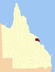
The County of Carlisle is a county (a cadastral division) in Queensland, Australia. The county is centred on the city of Mackay and includes most of the Mackay Region. It takes its name from Carlisle in England.[1][2]

On 7 March 1901, the Governor issued a proclamation legally dividing Queensland into counties under the Land Act 1897.[3] Its schedule described Carlisle thus:

Bounded on the south by the counties of Murchison, Wodehouse and Grosvenor; on the west by the eastern boundaries of Suttor Creek and Cerito portion B Resumption, Byerwen Consolidation and Havilah Lease, part of the south and the east boundaries of Sonomo Resumption, and by the east boundary of Henry O.L.; on the north by the south boundaries of Ellen Valley Consolidations, parts of the west and north boundaries of the Normanby Gold Field, part of the west and the south boundaries of Mountain Home Lease, the south boundary of Mountain Home Resumption, part of the north-west, the south and east boundaries of Bromby Park Lease to the Andromache River, by that river and the O'Connell River downwards to the sea-coast; and on the east by the sea-coast,—inclusive of all adjacent islands.

Parishes

Carlisle is divided into parishes, as listed below:

ParishLGACoordinatesTowns
AbingdonMackay21°12′S 148°54′E / 21.200°S 148.900°E / -21.200; 148.900 (Abingdon Parish)Marian, Mirani
BassettMackay21°05′S 149°07′E / 21.083°S 149.117°E / -21.083; 149.117 (Bassett Parish)North Mackay, Andergrove, Bucasia, Slade Point
BeverleyMackay21°21′S 149°45′E / 21.350°S 149.750°E / -21.350; 149.750 (Beverley Parish)(offshore)
BloomsburyMackay20°40′S 148°38′E / 20.667°S 148.633°E / -20.667; 148.633 (Bloomsbury Parish)Bloomsbury
Bong BongMackay21°20′S 148°45′E / 21.333°S 148.750°E / -21.333; 148.750 (Bong Bong Parish)
ChelonaMackay21°15′S 149°08′E / 21.250°S 149.133°E / -21.250; 149.133 (Chelona Parish)Chelona, Homebush
EtonMackay21°19′S 149°00′E / 21.317°S 149.000°E / -21.317; 149.000 (Eton Parish)Eton
GreenmountMackay21°10′S 149°03′E / 21.167°S 149.050°E / -21.167; 149.050 (Greenmount Parish)Walkerston
HamiltonMackay21°07′S 148°51′E / 21.117°S 148.850°E / -21.117; 148.850 (Hamilton Parish)
HampdenMackay21°04′S 149°00′E / 21.067°S 149.000°E / -21.067; 149.000 (Hampden Parish)Hampden, Habana
HazledeanMackay21°21′S 148°53′E / 21.350°S 148.883°E / -21.350; 148.883 (Hazledean Parish)
HectorMackay21°20′S 149°14′E / 21.333°S 149.233°E / -21.333; 149.233 (Hector Parish)Hay Point, Sarina Beach
HomebushMackay21°21′S 149°06′E / 21.350°S 149.100°E / -21.350; 149.100 (Homebush Parish)Munbura
HowardMackay21°11′S 149°10′E / 21.183°S 149.167°E / -21.183; 149.167 (Howard Parish)Mackay, Bakers Creek
IngotMackay20°42′S 149°10′E / 20.700°S 149.167°E / -20.700; 149.167 (Ingot Parish)(offshore)
KelvinMackay21°39′S 149°14′E / 21.650°S 149.233°E / -21.650; 149.233 (Kelvin Parish)Koumala
LacyMackay20°54′S 148°39′E / 20.900°S 148.650°E / -20.900; 148.650 (Lacy Parish)Yalboroo
MacartneyMackay20°41′S 148°31′E / 20.683°S 148.517°E / -20.683; 148.517 (Macartney Parish)
MartonMackay20°57′S 150°05′E / 20.950°S 150.083°E / -20.950; 150.083 (Marton Parish)(offshore)
Mia MiaMackay21°12′S 148°39′E / 21.200°S 148.650°E / -21.200; 148.650 (Mia Mia Parish)Finch Hatton, Pinnacle
Mount FunnelMackay21°35′S 149°21′E / 21.583°S 149.350°E / -21.583; 149.350 (Mount Funnel Parish)Cape Palmerston NP
OssaMackay20°58′S 148°55′E / 20.967°S 148.917°E / -20.967; 148.917 (Ossa Parish)Seaforth, Kuttabul, Mount Ossa
PelionMackay21°04′S 148°39′E / 21.067°S 148.650°E / -21.067; 148.650 (Pelion Parish)
SarinaMackay21°27′S 149°11′E / 21.450°S 149.183°E / -21.450; 149.183 (Sarina Parish)Sarina, Armstrong Beach
St HelensMackay20°52′S 148°46′E / 20.867°S 148.767°E / -20.867; 148.767 (St Helens Parish)Calen, Pindi Pindi
TeemburraMackay21°19′S 148°37′E / 21.317°S 148.617°E / -21.317; 148.617 (Teemburra Parish)

See also

References

  1. "Carlisle (entry 6254)". Queensland Place Names. Queensland Government. Retrieved 8 September 2015.
  2. South Kennedy District, County of Carlisle Maps - J5 Series at Queensland Archives.
  3. "A Proclamation". Queensland Government Gazette. 75. 8 March 1901. pp. 967–980.

Coordinates: 21°10′S 148°52′E / 21.167°S 148.867°E / -21.167; 148.867


This article is issued from Wikipedia. The text is licensed under Creative Commons - Attribution - Sharealike. Additional terms may apply for the media files.