County of Solander

Solander
Queensland
Location within Queensland
Lands administrative divisions around Solander:
Banks Pacific Ocean Pacific Ocean
Dagmar Solander Pacific Ocean
Dagmar Dagmar Nares

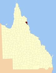
The county of Solander is a cadastral division of Queensland which contains the towns of Ayton, Daintree, Mossman and Port Douglas. It was originally the southern part of the county of Banks when the counties were named and bounded in 1901.[1][2]

Parishes

Solander is subdivided into parishes, listed as follows:

ParishLGACoordinatesTowns
AlexandraDouglas16°12′S 145°29′E / 16.200°S 145.483°E / -16.200; 145.483 (Alexandra Parish)Alexandra Bay
AmyDouglas16°4′S 144°57′E / 16.067°S 144.950°E / -16.067; 144.950 (Amy Parish)
BloomfieldDouglas16°4′S 145°9′E / 16.067°S 145.150°E / -16.067; 145.150 (Bloomfield Parish)
ClerkCook15°54′S 145°17′E / 15.900°S 145.283°E / -15.900; 145.283 (Clerk Parish)Ayton
DagmarDouglas16°13′S 145°12′E / 16.217°S 145.200°E / -16.217; 145.200 (Dagmar Parish)
DedinDouglas16°22′S 145°16′E / 16.367°S 145.267°E / -16.367; 145.267 (Dedin Parish)
KingsdaleCook15°47′S 144°57′E / 15.783°S 144.950°E / -15.783; 144.950 (Kingsdale Parish)
MowbrayDouglas16°36′S 145°27′E / 16.600°S 145.450°E / -16.600; 145.450 (Mowbray Parish)
NoahDouglas16°6′S 145°21′E / 16.100°S 145.350°E / -16.100; 145.350 (Noah Parish)Cape Tribulation
PhippsCook15°50′S 145°7′E / 15.833°S 145.117°E / -15.833; 145.117 (Phipps Parish)
SalisburyDouglas16°32′S 145°26′E / 16.533°S 145.433°E / -16.533; 145.433 (Salisbury Parish)Port Douglas
SporingCook15°55′S 145°6′E / 15.917°S 145.100°E / -15.917; 145.100 (Sporing Parish)
SpurgeonDouglas16°13′S 145°4′E / 16.217°S 145.067°E / -16.217; 145.067 (Spurgeon Parish)
TribulationDouglas16°00′S 145°22′E / 16.000°S 145.367°E / -16.000; 145.367 (Tribulation Parish)
VictoryDouglas16°30′S 145°21′E / 16.500°S 145.350°E / -16.500; 145.350 (Victory Parish)Mossman
WhyanbeelDouglas16°22′S 145°22′E / 16.367°S 145.367°E / -16.367; 145.367 (Whyanbeel Parish)Daintree

References

  1. "Solander - county (entry 31356)". Queensland Place Names. Queensland Government. Retrieved 21 June 2017.
  2. Cook District, County of Solander Maps - Q4 Series at Queensland Archives.

Coordinates: 16°29′S 145°27′E / 16.483°S 145.450°E / -16.483; 145.450

This article is issued from Wikipedia. The text is licensed under Creative Commons - Attribution - Sharealike. Additional terms may apply for the media files.