Kathiawar
Kathiawar ([kaʈʰijaʋaɽ]; also written Kathiawad or Kattywar) is a peninsula in western India and part of the Saurashtra region.[1][2][3][4][5] Its coastline borders the Gulf of Kutch to the west, the Arabian Sea to the south and the Gulf of Khambhat to the southeast and east. Jigat Point is located at its western apex and Diu Head at its southern.
Etymology and history

The word Kathiawad means the land of the Kathis, a Rajput tribe of Scythian or Indo-Getic origin who migrated to the region in the 8th century and controlled the southwestern peninsula of contemporary Gujarat.[6][7] Kathis were widespread in the region and dominated central Saurashtra in particular for some centuries. Although the Kathis are believed to have migrated to the area as late as the 16th century, they have played an important part in the documented history of the region. During the reign of India Pratihar ruler Mihir Bhoj, the Gurjar empire stetched from Kathiawad to the Bay of Bengal.[8] A Haddola inscription confirms that Gurjar Pratihars continued to rule in this region during the reign of Mahipala I too.[9] The peninsula is dotted with antiquities and has a continuous history from prehistoric times to the early periods of the Mahabharata through the Indus civilization. It was influenced by Kathi people in particular between the 16th century to the mid 20th century and therefore the emergent name of Kathiawar became a favourite alternative to the region of Saurashtra.
In a geopolitical context, the area of Kathiawar forms the core of Saurashtra. In feudal times, there were certain principle divisions of Saurashtra falling under princely states, namely Kathiawad, Sorath, Gohilwad, Halar, Panchal & Zalawad, Nagher, Okha Mandal, etc. However, the main area of Kathiawar covered 10 districts : Rajkot, Bhavnagar, Jamnagar, Surendranagar, Porbandar, Amreli, Junagadh, Botad, Morvi, Gir-somnath. Some historians suggest that the Kathi people are basically Scythians who migrated to Saurashtra (referred to as Saraostus as well, by contemporary Greeks) around the second century BC.
For a long period, the name Sorath remained limited to the region when the Chudasama Rajput (Raa' dynasty) ruled from 875 to 1473. Concurrently, major Rajput clans that held a sway over this region included the Walas (Kathis), Jethwas, Raijadas, Chudasamas, Gohils, Jhalas, Jadejas, Chavdas, Parmars, Patgirs or Pargirss, Sarvaiyas, Solankis and Khachars. Most of the princely states of Kathiawar were brought under the British protectorate by 1820, but from Kathiawad first treaty with the British was made by Vira Wala (Kathi Ruler) of Jetpur with Colonel Walker at Baroda on 26 October 1803.
Literary Comment
| Wikisource has original text related to this article: |
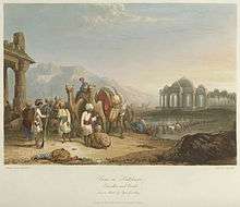
The state of the region in the early nineteenth century is illustrated in Letitia Elizabeth Landon's poem, Scene in Kattiawar, based on the print shown below (Travellers and Escort, 1830).
Political history
Before Indian independence in 1947, most of Kathiawar was divided into numerous princely states, ruled by local potentates who acknowledged British suzerainty in return for local sovereignty. These states comprised the Kathiawar Agency. The rest of the peninsula, chiefly in the east along the Gulf of Cambay, were districts ruled directly by the British as part of British India's Bombay Presidency, which included part of the peninsula.
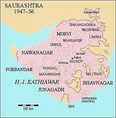
After Indian independence, the states of Kathiawar acceded to India. In 1947, Junagadh's Muslim ruler acceded his territory to Pakistan. The predominantly Hindu population rebelled, and while the prince fled to Pakistan, a plebiscite was conducted, after which the kingdom was merged into the Indian Union. The former princely states of Kathiawar were grouped into the new province of Saurashtra, which became Saurashtra State in 1950. In 1956, Saurashtra was merged into Bombay State, and in 1960, Bombay state was divided along linguistic lines into the new states of Gujarat (including Kathiawar) and Maharashtra. Diu remained in Portuguese hands until 1961, when it was occupied by Indian troops, then became integrated into India as part of the union territory of Goa, Daman and Diu in 1962.
Major cities
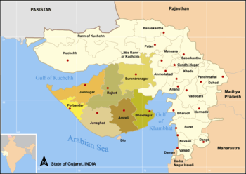
The major cities of Kathiawar are Rajkot in the center of the peninsula, Jamnagar on the Gulf of Kutch, Bhavnagar on the Gulf of Khambhat, Surendranagar and the historic city Wadhwan in the central portion of Gujarat, Porbandar on the west coast, historic city of Junagadh on the South. Diu, an island town formerly part of Portuguese India and now part of the Indian union territory of Daman and Diu, lies off the south coast of Kathiawar. The city of Somnath and its famous temple are also located on the south coast.
Districts in Kathiawar Region
Geography and ecosystem
The natural vegetation on most of the peninsula is xeric scrub, part of the Northwestern thorn scrub forests ecoregion. A range of low hills, known as the Gir Hills, occupies the south-central portion of the peninsula. The highest of these is Girnar. The hills are home to an enclave of tropical dry broadleaf forest, part of the Kathiawar-Gir dry deciduous forests ecoregion. Gir National Park, which includes the forested hills around Girnar, and areas in the region that neighbor it, are home to the last remaining Asiatic lions in the wilderness of the Earth.[2][3][4][5] Other national parks on Kathiawar are Blackbuck National Park (Velavadar) on the Gulf of Cambay, and Marine National Park on the Gulf of Kutch, near Jamnagar.
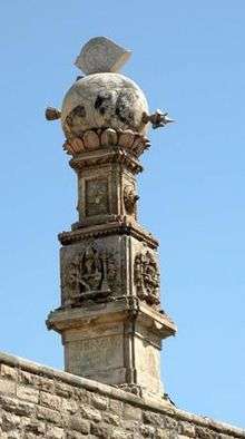
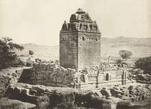
Antiquity (places: history, archaeology, nature, religion)
- Dwarika
- Somnath
- Sasan Gir and interiors / Kathi territories in Amreli-Bhavnagar districts
- Vallabhi
- Porbandar
- Junagadh
- Shatrunjay Hills, Palitana
- Sihor
- Virpur (Rajkot) and Gondal
- Jamnagar & Marine National Park
- Velavadar
- Old cities of Wadhvan, Morbi, Wankaner
- Diu, India

Notable characters and figures
The list of some divine, notable figures, characters and events related to Kathiawar-Saurashtra can be very exhaustive. Covering different sections, fields and class of society, a few of them are as following:
Religion, pre-history, spirituality
- Sudama – Krishna's friend and a character from Mahabharata
- Baba Balak Nath – One of the legendary Naths and Chaurasi Siddhas
- Neminath – One of the Siddhas and 22nd Jain Tirthankar
- Narsinh Mehta (1414-1481) – Poet and Saint
- Dayanand Saraswati – Hindu religious scholar, reformer, and founder of the Arya Samaj
- Jalaram Bapa – A mystic and Saint
- Shrimad Rajchandra – A prominent Jain philosopher
- Morari Bapu – Preacher, teacher, Thinker
- Ramesh Bhai Ojha (Hindi: रमेश भाई ओझा) Hindu spiritual leader and preacher of Vedanta Philosophy.
- Ghanshyam Pande religious preacher and reformer saint also known as Swaminarayan.
- Gangasati - Paanbai & Kahadsinhji Gohil mystic saints near samadhiyala.
- Kanji Swami Jain Scholar & Saint of Songadh, Also known as Kohinoor of Kathiawad.
Society, ideology, politics, leadership
- Mohandas Karamchand Gandhi – pre-eminent political and ideological leader of India, and Father of Nation
- Muhammad Ali Jinnah – lawyer, politician, statesman and the founder of Pakistan and Pakistani 'Father of the Nation'
- U. N. Dhebar – Freedom Fighter (Indian independence), and President of the Indian National Congress
- Virchand Gandhi – First Gujarati Patriot from Mahuva to visit USA officially and Participate in First World Religion Parliament, 1893. (key Member of Indian National Congress)
- Fatima Jinnah – Mother of Pakistani Nation ('Māder-e Millat')
Governance, nobility, reforms, politics
- Nawab Sir Muhammad Mahabat Khan III, Babi of Junagadh state
- Maharaja Sir Takhtsinhji Gohil of Bhavnagar – Reformist and progressive ruler, also constructed Bhavnagar State Railway covering Saurashtra
- Maharaja Bhagvatsinhji of Gondal – A progressive and enlightened ruler, wrote classical and rare 'Bhagavadgomandal', dictionary cum encyclopaedia of Saurashtra – Gujarat and Gujarati language
- Maharaja Krishnakumar Sinjhji Gohil – Reformist, progressive and noble Maharaja of Bhavnagar
- Balwantrai Mehta – Freedom fighter, social worker and pioneer of concept of Panchayati Raj
- Jivraj Mehta – Politician, first Chief Minister of Gujarat
Art, literature, poetry, journalism, socialism
- Jhaverchand Meghani – Litterateur, social reformer and freedom fighter
- Kalaguru Ravishankar Raval- a painter, art teacher, art critic, journalist and essayist
- Dalpatram – Poet of Gujarati literature
- Nanalal Dalpatram Kavi – Author and poet
- Sursinhji Takthasinhji Gohil – Known as Kalapi – Poet, Gujarati literature – Royal family
- Dula Bhaya Kag – Poet, social reformer and freedom fighter
- Amrut Ghayal – Poet and Shayar of Gujarati Ghazal
- Kavi Kant – Poet
- Harilal Upadhyay[10] – Author in the Gujarati language
- Chunilal Madia – Author, playwright, poet, journalist, editor
- Ghulam Mohammed Sheikh – Painter, writer, art critic
- Rajendra Shukla – Poet
- Ramesh Parekh-poet
Sports, adventure
- K. S. Ranjitsinhji – Maharaja of Nawanagar, cricketer
- Kumar Shri Duleepsinhji – Indian Cricketer, Princely States
- Vinoo Mankad – Indian Cricketer
- Ashok Mankad – Indian Cricketer
- Dilip Doshi – Indian Cricketer
- Karsan Ghavri – Indian Cricketer
- Ashok Patel – Indian Cricketer
- Dhiraj Parsana – Indian Cricketer
- Ajay Jadeja – Indian Cricketer
- Parthiv Patel – Indian Cricketer
- Ravindra Jadeja – Indian Cricketer
- Siddharth Trivedi – Indian Cricketer
- Cheteshwar Pujara – Indian Cricketer
Cinema, entertainment, music, folklore
- Mohammed Chhel – A magician and a Fakir (mystic)
- Vijay Bhatt – a noted producer-director-screenwriter
- Nanabhai Bhatt – Indian film director and producer – father of Mahesh Bhatt & Mukesh Bhatt
- Dina Pathak – Veteran actor, director of Gujarati theatre, woman activist
- Asha Parekh – Actress, director, and producer
- Shahabuddin Rathod – Humorist, writer, teacher
- Parveen Babi – Bollywood actress
- Dimple Kapadia – Bollywood actress
- Manhar Udhas – One of the top Ghazalkars
- Pankaj Udhas – Indian singer, Ghazal Singer
- Mehul Kumar – Director, producer
- K. Lal – Indian Magician
- Alka Yagnik – Singer
- Ben Kingsley – Actor (ancestral roots in Saurashtra)
- Hemant Chauhan – Singer, Bhajanik
- Neeraj Vora – Film director, dialogue writer, actor
- Himesh Reshammiya – Music Composer, Singer, artist
- Dilip Joshi-Cinema and television actor(Lead role as Jethalal Gada In Tarak Mehta Ka Ooltah Chashma)
- Anjum Rajabali – screenwriter, actor, producer
- Chhel Vayeda – Art director and production designer
- Pan Nalin – Film director, screenwriter and documentary maker
- Sanjay Chhel – Film director, writer and lyricist
Business, industry, innovation, entrepreneurship, philanthropy
- Nanji Kalidas Mehta – Industrialist and Philanthropist
- Muljibhai Madhvani – Businessman, entrepreneur, industrialist and philanthropist
- Nautamlal Bhagavanji Mehta – Freedom fighter, businessman
- Dhirubhai Ambani – An Indian business magnate and entrepreneur who founded Reliance Industries
- Abdul Gaffar Billoo – Pakistani pediatric endocrinologist and philanthropist.
- Sam Pitroda – Inventor, entrepreneur and policymaker
- Tulsi Tanti – Chairman and managing director of Suzlon Energy
- Abdul Sattar Edhi father teresa of Pakistan, Edhi Foundation-helping poor n needy in medical helps there.
History, culture, bravery, events
- Prince Vijaya – Exiled Prince of Sihor colonising Sri Lanka
- Ra Navghan – Historical Character of Greatness during Solanki period
- Kadu Makrani – An Archetypal, and insurgent Indian rebellion of 1857
- Banda Bahadur one of the punj pyare of Sikh religion, was born in Dwarka, brave warrior.
See also
References
- ↑ "Gujarat Map". mapsofindia.com. Retrieved 2016-03-21.
- 1 2 Geptner, V. G., Sludskij, A. A. (1972). Mlekopitajuščie Sovetskogo Soiuza. Vysšaia Škola, Moskva. (In Russian; English translation: Heptner, V.G., Sludskii, A. A., Komarov, A., Komorov, N.; Hoffmann, R. S. (1992). Mammals of the Soviet Union. Vol III: Carnivores (Feloidea). Smithsonian Institution and the National Science Foundation, Washington DC).
- 1 2 Pocock, R. I. (1939). The Fauna of British India, including Ceylon and Burma. Mammalia. – Volume 1. Taylor and Francis Ltd., London. Pp. 199–222.
- 1 2 Nowell, Kristin; Jackson, Peter (1996). "Panthera Leo". Wild Cats: Status Survey and Conservation Action Plan (PDF). Gland, Switzerland: IUCN/SSC Cat Specialist Group. pp. 17–21. ISBN 2-8317-0045-0.
- 1 2 "Asiatic Lion population up from 411 to 523 in five years". Desh Gujarat. 2015-05-10. Retrieved 2016-11-26.
- ↑ Chandrani, Yogesh. "Legacies of Colonial History: Region, Religion, and Violence in Postcolonial Gujarat" (PDF) (1): 2.
- ↑ Edward Balfour (1885). The Cyclopædia of India and of Eastern and Southern Asia: Commercial, Industrial and Scientific, Products of the Mineral, Vegetable, and Animal Kingdoms, Useful Arts and Manufactures. B. Quaritch. pp. 521–.
- ↑ Baij Nath Puri (1986). The history of the Gurjara-Pratihāras. Munshiram Manoharlal Publishers. p. xvii.
- ↑ Narendra Singh (2001). Encyclopaedia of Jainism. Anmol Publications PVT. LTD.
- ↑ "A Few Words about Shri Harilal Upadhyay"

| Topics | 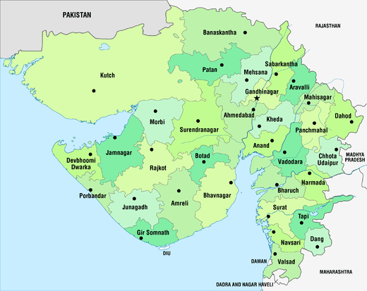 | |
|---|---|---|
| Regions of Gujarat | ||
| Districts | ||
| Major cities | ||
| Ecoregions | ||
| Economy |
| |
| ||