Rann of Kutch
| Rann of Kutch | |
|---|---|
| Natural region | |
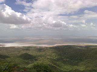 Landscape in the Rann of Kutch | |
 Rann of Kutch seasonal salt marsh ecoregion | |
| Country | India & Pakistan |

The Rann of Kutch is a large area of salt marshes located mostly in Gujarat (primarily the Kutch district), India and the southern tip of Sindh, Pakistan. It is divided into two main parts: Great Rann of Kutch and Little Rann of Kutch.
Geography
The Rann of Kutch is located in the Thar Desert bio-geographic area in the Indian state of Gujarat, with some parts in Pakistani province of Sindh. It is a seasonally marshy region, the word Rann meaning "salt marsh", alternating with medaks, elevated pieces of land where vegetation grows. Kori Creek and Sir creek are located in Rann of Kutch area which is part of Indus river delta.
Kutch is the name of the district in Gujarat where this region is situated. The marsh covers a huge area of around 10,000 square miles and is positioned between the Gulf of Kutch and the mouth of the Indus River in southern Pakistan. Many rivers located in Rajasthan and Gujarat flow in to Rann of Kutch. These are Luni, Bhuki, Bharud, Nara, Kharod, Banas, Sarswati, Rupen, Bambhan, Machchhu, etc.[1]
Ecological importance
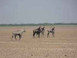
The Rann of Kutch is the only large flooded grasslands zone in the whole Indo-Malayan region.[2] The fact that the area has desert on one side and the sea on the other provides the Rann of Kutch with a variety of ecosystems, including mangroves and desert vegetation.[3] The grassland and deserts of the Rann of Kutch are home to forms of wildlife that have adapted to the often harsh conditions of this vast area. These include endemic and endangered animal and plant species.[4]
See also
References
- ↑ "Rivers of Gujarat in Kutch region". guj-nwrws.gujarat.gov.in, Government of Gujarat. Retrieved 13 March 2018.
- ↑ WWF - Rann of Kutch Flooded Grasslands Archived 2014-07-22 at the Wayback Machine.
- ↑ Negi, Sharad Singh (1996). Biosphere reserves in India: landuse, biodiversity and conservation. Indus Publishing. p. 221. ISBN 9788173870439.
- ↑ Sharma, R.P. (10 Nov 2011). The Indian forester, Volume 127, Issues 7-12. University of Minnesota.
External links
- Southern Asia: Western India into Pakistan - Ecoregions
- Global Species : Ecoregion : Rann of Kutch seasonal salt marsh
Coordinates: 24°05′11″N 70°38′16″E / 24.08639°N 70.63778°E