Ahmedabad district
| Ahmedabad District | |
|---|---|
| District | |
 Ahmedabad location in Gujarat | |
| Country |
|
| State | Gujarat |
| Headquarters | Ahmedabad |
| Government | |
| • District Collector | Vijaysinh Vaghela |
| Area | |
| • Total | 8,107 km2 (3,130 sq mi) |
| Population (2011)[1] | |
| • Total | 7,059,056 |
| • Rank | 1 of 33 in Gujarat |
| • Density | 870/km2 (2,300/sq mi) |
| Demonym(s) | Amdavadi |
| Time zone | I |
| • Summer (DST) | IST (UTC+05:30) |
| Vehicle registration | GJ-1, GJ-27 |
| Website |
gujaratindia |
Ahmedabad District comprises the city of Ahmedabad, in the central part of the state of Gujarat in western India. It is the seventh most populous district in India (out of 640).[2]
History

Ahmedabad district was a part of Bombay Presidency encompassing several subdivisions.
Geography
Ahmedabad District is surrounded by Mehsana and Gandhinagar districts to the north, Kheda and Anand Districts to the east, the Gulf of Khambhat (Gulf of Cambay), Botad and Bhavnagar districts to the south, and Surendranagar district to the west. Its headquarters is the city of Ahmedabad.9 talukas of the District include 474 villages, 1 deserted village, 1 corporation, 1 cantonment area and 7 municipalities.
Climate
| Climate data for Ahmedabad | |||||||||||||
|---|---|---|---|---|---|---|---|---|---|---|---|---|---|
| Month | Jan | Feb | Mar | Apr | May | Jun | Jul | Aug | Sep | Oct | Nov | Dec | Year |
| Average high °C (°F) | 28.3 (82.9) |
30.4 (86.7) |
35.6 (96.1) |
39.8 (103.6) |
41.5 (106.7) |
38.4 (101.1) |
33.4 (92.1) |
31.8 (89.2) |
34.0 (93.2) |
35.8 (96.4) |
32.8 (91) |
29.3 (84.7) |
41.5 (106.7) |
| Average low °C (°F) | 20.1 (68.2) |
13.9 (57) |
18.9 (66) |
23.7 (74.7) |
26.2 (79.2) |
27.2 (81) |
25.6 (78.1) |
24.6 (76.3) |
24.2 (75.6) |
21.1 (70) |
16.6 (61.9) |
13.2 (55.8) |
11.8 (53.2) |
| Average rainfall mm (inches) | 2.0 (0.079) |
1.0 (0.039) |
0 (0) |
3.0 (0.118) |
20 (0.79) |
103.0 (4.055) |
247.0 (9.724) |
288.0 (11.339) |
83.0 (3.268) |
23.0 (0.906) |
14.0 (0.551) |
5.0 (0.197) |
789 (31.06) |
| Average rainy days (≥ 0 mm) | 0.3 | 0.3 | 0.1 | 0.3 | 0.9 | 4.8 | 13.6 | 15.0 | 5.8 | 1.1 | 1.1 | 0.3 | 43.6 |
| Mean monthly sunshine hours | 288.3 | 274 | 279 | 307 | 329 | 237.0 | 130 | 111.6 | 222 | 291 | 273 | 288.3 | 3,020 |
| Source: HKO[3] | |||||||||||||
Divisions
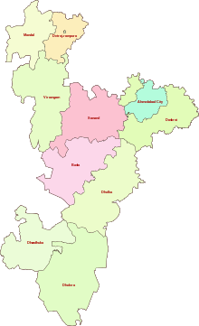
Ahmedabad District is divided into ten talukas.
Talukas
Localities in Ahmedabad City
- Bapunagar
- Dariyapur - Old City
- Shahpur - Old City
- Khanpur - Old City
- Kalupur - Old City
- Kubernagar
- Jamalpur - Old City
- Behrampura
- Shah-e-Alam - Old City
- Mirzapur - Old City
- Bapunagar
- Danilimada
- Chandola Lake
- Kankaria Lake
- Shahibaug
- Bodakdev
- Maninagar
- Vastrapur
- Nava Vadaj
- Ambawadi
- Ellis Bridge
- Navrangpura
- Naranpura
- Ghatlodiya, Ghatlodiya_(Vidhan_Sabha_constituency)
- Naroda
- Paldi
- Bopal
- Ranip
- Gota
- Sarkhej
- Vasana
- Vejalpur
- Gomtipur
- C.G. Road
- Law Garden
- Lal Darwaja
- Prahladnagar
- Teen Darwaja
- Satellite
- Jivraj Park
- Guptanagar
- Narol
- Vatwa
- Shahwadi
- Gurukul
- Raipur
- Aastodia
- Meghani nagar
- Isanpur
- Ghodasar
- Chandkheda
- Juhapura
- Vastral
- Thaltej
- Shilaj
- Chandlodiya
Demographics
According to the 2011 census Ahmedabad district has a population of 7,045,314,[2] roughly equal to Hong Kong[4] or the US state of Washington.[5] This gives it a ranking of 8th in India (out of a total of 640).[2] The district has a population density of 983 inhabitants per square kilometre (2,550/sq mi) .[2] Its population growth rate over the decade 2001-2011 was 22.31%.[2] Ahmedabad has a sex ratio of 903 females for every 1000 males,[2] and a literacy rate of 86.65%.[2]
It had a population of 5,816,519 of which 80.18% were urban as of 2001.[6]
The language people speak in Ahmedabad is Gujarati which is the mother-tongue of the State of Gujarat, in addition to Hindi which is also quite popular among the people.
Culture
Notable personalities
Acharya Hemachandra (1089–1172) Jain polymath. Born in Dhandhuka.[7]
References
- ↑ "Districts of Gujarat".
- 1 2 3 4 5 6 7 "District Census 2011". Census2011.co.in. 2011. Retrieved 2011-09-30.
- ↑ "Ahmedabad Climate Record". Retrieved 1 May 2012.
- ↑ US Directorate of Intelligence. "Country Comparison:Population". Retrieved 2011-10-01.
Hong Kong 7,122,508 July 2011 est.
- ↑ "2010 Resident Population Data". U. S. Census Bureau. Archived from the original on 2010-12-25. Retrieved 2011-09-30.
Washington 6,724,540
- ↑ "Archived copy". Archived from the original on 2010-01-11. Retrieved 2012-11-17.
- ↑ "Hemacandra". Jain World. Archived from the original on April 29, 2008. Retrieved 2008-05-06.
External links
Places adjacent to Ahmedabad district | |
|---|---|
| Topics | 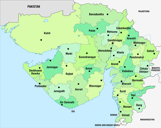 | |
|---|---|---|
| Regions of Gujarat | ||
| Districts | ||
| Major cities | ||
| Ecoregions | ||
| Economy |
| |
| ||