Saurashtra (region)
| Saurashtra Kathiawad | |
|---|---|
| Region | |
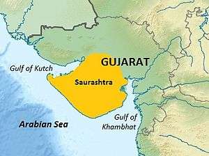 Saurashtra region within Gujarat, India | |
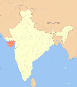 Location of Saurashtra in India | |
| Coordinates: 22°18′00″N 70°47′00″E / 22.3000°N 70.7833°ECoordinates: 22°18′00″N 70°47′00″E / 22.3000°N 70.7833°E | |
| Country | India |
| State | Gujarat |
| Area | |
| • Total | 66,000 km2 (25,000 sq mi) |
| Languages | |
| • Official | Gujarati |
| Time zone | UTC+5:30 (IST) |
| Vehicle registration | GJ |
| Large cities |
Rajkot, Jamnagar, Bhavnagar, Morbi Junagadh, Porbandar, Veraval, Surendranagar |
Saurashtra, also known as Sorath or Kathiawar,[1] is a peninsular region of Gujarat, India, located on the Arabian Sea coast. It covers about a third of Gujarat state, notably 11 districts of Gujarat, including Rajkot District.
Location
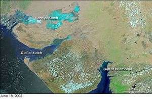
Saurashtra peninsula is bound on the south and south-west by the Arabian sea, on the north-west by the Gulf of Kutch and on the east by the Gulf of Khambhat. From the apex of these two gulfs, the Little Rann of Kutch and Khambhat, waste tracts half salt morass half sandy desert, stretch inland towards each other and complete the isolation of Kathiawar, except one narrow neck which connects it on the north-east with the mainland of Gujarat.[2][3]
The peninsula is sometimes referred to as Kathiawar after the Kathi Darbar, which once ruled most of the region. However, Saurashtra is not entirely synonymous with Kathiawar, since a small portion of the historical Saurashtra region extends beyond the Kathiawar peninsula. Sorath forms the southern portion of the peninsula.
Districts
The Saurastra region comprises the south western part of modern Gujarat state and the districts included in this region are:
- Devbhoomi Dwarka
- Jamnagar
- Morbi
- Rajkot
- Porbandar
- Junagadh
- Gir Somnath
- Amreli- rajula
- Bhavnagar
- Botad
- Surendranagar
- Ahmedabad (part) {Dhandhuka taluka}
The region also historically encompassed the Diu district of the Daman and Diu union territory.[4]
History
Referred to as Saurashtra and as some other names as well over a period of time, since the Mahabharata and Vedic period, this region is mentioned again as Surastrene, or Saraostus in the 1st century CE Periplus of the Erythraean Sea:
| “ | "Beyond the gulf of Baraca is that of Barygaza and the coast of the country of Ariaca, which is the beginning of the Kingdom of Nambanus and of all India. That part of it lying inland and adjoining Scythia is called Abiria, but the coast is called Syrastrene. It is a fertile country, yielding wheat and rice and sesame oil and clarified butter, cotton and the Indian cloths made therefrom, of the coarser sorts. Very many cattle are pastured there, and the men are of great stature and black in colour. The metropolis of this country is Minnagara, from which much cotton cloth is brought down to Barygaza. | ” |
| — Periplus, Chap. 41 | ||
Surashtra and its Prakrit name Sorath, literally means "good country". The name finds mentions in the Junagadh Rock inscription dating 150 CE, attributed to Rudradaman I. Prior to this, during the rule of Ashoka (268–232 BCE), the region was under Yavana Tushaspa, and governed by Pushyagupta during Chandragupta Maurya's reign (322BC – 298BC).[5] Vrajlal Sapovadia noted from literature and Tamil Nadu Government record that around AD 1000, a community left Saurashtra region to South India and are known as the Saurashtra people.[6]
Gir
For a long time, the name Sorath referred to this region. From the 9th to 14th century Chudasama Rajput ruled Sorath with their capitals Vanthali and Junagadh alternatively. The Chudasama Rajputs ruled Sorath longer than any others, until the Sorath area came under Muslim rule. Sorath, a Muslim corruption of Saurashtra, was initially one of ten prants, but by the colonial age it was one of only four surviving ones, the others being absorbed. The salute state Junagadh (alias "Junagarh" or the "Old Fort"), founded during British rule, and its neighbouring states were controlled by the Western India States Agency (WISA). In 1947, Junagadh's Muslim ruler desired to accede his territory to Pakistan, but the predominantly Hindu population rebelled.
Saurashtra State
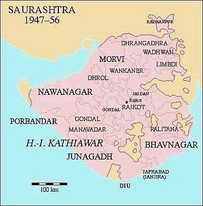
After India's independence in 1947, 217 princely states of Kathiawar, including the former Junagadh State, were merged to form the state of Saurashtra on 15 February 1948. Initially, it was named United State of Kathiawar, which was renamed to Saurashtra State in November 1948. The exercise took up a lot of Shri Vallabhbhai Patel's time to convince the local princes and petty subas (totalling 222 in Saurashtra alone). However, Maharaja Krishnakumar Sinhji of Bhavnagar State readily extended to offer his large and royal empire of Bhavnagar / Gohilwar to Sardar Vallabhbhai Patel, and Bhavnagar became the first in the country to be merged into the union of India.
The capital of Saurashtra was Rajkot. Uchharangray Navalshankar Dhebar, who later went on to become President of the Indian National Congress between 1955 and 1959, became Saurashtra's first Chief Minister. He was succeeded by Rasiklal Umedchand Parikh on 19 December 1954.
On 1 November 1956, Saurashtra was merged into Bombay state. In 1960 Bombay state was divided along linguistic lines into the new states of Gujarat and Maharashtra. The territory of Saurashtra, including Junagadh and all of Sorath, became part of the state of Gujarat.
Language
Saurashtra (alternate names and spellings: Sourashtra, Sowrashtra, Palkar) is also the name of an Indo-Aryan language of Kathiawar-Saurashtra. Though the Saurashtra language is not spoken in the region now, people of this region who migrated to Southern India - especially Karnataka (Bengaluru), Tamil Nadu (Ambur, Madurai, Dindigul, Paramakudi, Salem, Tanjore, Trichy, Namakkal, Kanyakumari, Kanchipuram, Walajapet, Arani, Chennai, Palayamkottai, Kumbakonam, Thirubuvanam) and Andhra Pradesh - still preserve and speak the language. The script of this language is derived from the Devanagari script and shares similarities with modern-day Gujarati.[7]
Postage stamps
The first postage stamps of the state were issued for Princely State of Junagadh in 1864. They consisted of three lines of Hindi script in colourless letters on black, and were produced by hand-stamping with watercolor ink. A second issue in 1868 used coloured letters, printed in black or red on several colours of paper.
The issue of 1877 was the first to include Latin letters; the circular design included the inscription "SORUTH POSTAGE" at the top, and "ONE ANNA OF A RUPEE" (or "FOUR ANNAS...") at the bottom. Some of these were surcharged in 1913–14, followed by redesigned stamps in 1914.
A set of eight stamps in 1929 included pictures of Junagadh, the Gir lion, and the Kathi horse in addition to the nawab. In 1937 the one anna value was reissued reading "POSTAGE AND REVENUE".
The Indian province of Saurashtra did not design any of its own stamps, but before adopting the stamps of India, Saurashtra issued a court fee stamp overprinted for postal use, then created more one anna stamps by surcharging three stamps of the 1929 issue.
Natural resources
Saurashtra has been a flourishing region and rich in natural resources since ancient times, while having gone through several droughts especially during the 20th century. Water resources and its related dynamics have influenced the region and its agro-economy to a certain extent. It is found that water was easily available in the region 10–15 years ago. Ashvin A. Shah, a US-based engineering consultant who conducted a survey in 1998 on water availability in the region, says, "The presence of 700,000 dugwells in Saurashtra region indicates the presence of extensive groundwater aquifers throughout the region. This means there is one well for fewer than 20 people or one well every 300 metres".
Amri Saurashtra went through severe droughts over the years to the extent that people could no longer grow crops, nor did they have drinking water available. There has been in recent times a campaign to take up rain water harvesting.[8]
Significantly, the Check dam campaign from the late 1990s brought almost a drastic change resulting in raising water tables in Saurashtra.[9]
| Wikimedia Commons has media related to Saurashtra. |
Notes and references
- ↑ Ray, Bharati (2009). Different Types of History. Pearson Education India. p. 365. ISBN 9788131718186.
- ↑ Gazetteer of the Bombay Presidency: Káthiáwár. Vol. 8 1884, p. 3.
- ↑ Dave, Puffy I (October 2009). "Preservation of Kathiawari folk literature and arts". Indian Journal of Traditional Knowledge. CSIR. 8 (4): 626–628. ISSN 0975-1068 – via NISCAIR Online Periodicals Repository.
- ↑ History of Diu – Diu Tourism Department – India
- ↑ Tej Ram Sharma (1978). Personal and geographical names in the Gupta inscriptions. Concept Publishing Co., Delhi. p. 211.
- ↑ "Saurashtra: A Language, Region, Culture & Community". Sapovadia's Blog.
- ↑ "Saurashtra". Ethnologue. Retrieved 2018-02-26.
- ↑ "Water in the wells". rainwaterharvesting.org.
- ↑ "Check-dams raise water table in Saurashtra". The Times of India.
Sources and external links
- Gazetteer of the Bombay Presidency: Káthiáwár. Vol. 8. Google Books. 1884. Retrieved 24 January 2016.
- Ron Wood, Soruth (Handbook of Indian Philately, Series 2, Hampshire, UK: The India Study Circle for Philately, 1999)
- Sapovadia, Vrajlal K., Saurashtra: A Language, Region, Culture & Community (3 April 2012). Available at SSRN: http://ssrn.com/abstract=2033685
| Topics | 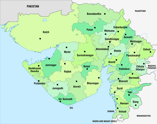 | |
|---|---|---|
| Regions of Gujarat | ||
| Districts | ||
| Major cities | ||
| Ecoregions | ||
| Economy |
| |
| ||