Jardin, Isère
| Jardin | ||
|---|---|---|
| Commune | ||
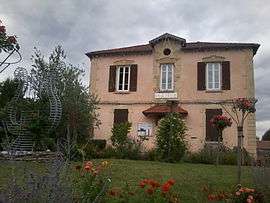 The town hall of Jardin | ||
| ||
 Jardin Location within Auvergne-Rhône-Alpes region  Jardin | ||
| Coordinates: 45°29′50″N 4°54′32″E / 45.4972°N 4.9089°ECoordinates: 45°29′50″N 4°54′32″E / 45.4972°N 4.9089°E | ||
| Country | France | |
| Region | Auvergne-Rhône-Alpes | |
| Department | Isère | |
| Arrondissement | Vienne | |
| Canton | Vienne-2 | |
| Intercommunality | Pays Viennois | |
| Government | ||
| • Mayor (2014–2020) | Thierry Quintard | |
| Area1 | 9.25 km2 (3.57 sq mi) | |
| Population (2011)2 | 2,248 | |
| • Density | 240/km2 (630/sq mi) | |
| Time zone | UTC+1 (CET) | |
| • Summer (DST) | UTC+2 (CEST) | |
| INSEE/Postal code | 38199 /38200 | |
| Elevation |
194–407 m (636–1,335 ft) (avg. 280 m or 920 ft) | |
|
1 French Land Register data, which excludes lakes, ponds, glaciers > 1 km2 (0.386 sq mi or 247 acres) and river estuaries. 2 Population without double counting: residents of multiple communes (e.g., students and military personnel) only counted once. | ||

Jardin is a commune in the Isère department in southeastern France. It is a suburb of Vienne.
It is located 4km from the centre of Vienne and 35km south of Lyons.
History
The name 'Jardin' is French for 'garden', reflecting the area's traditional history as a vegetable garden serving the town of Vienne and the manor of Montleans.
Population
| Historical population | ||
|---|---|---|
| Year | Pop. | ±% |
| 1793 | 295 | — |
| 1806 | 396 | +34.2% |
| 1821 | 457 | +15.4% |
| 1831 | 495 | +8.3% |
| 1841 | 580 | +17.2% |
| 1851 | 627 | +8.1% |
| 1861 | 625 | −0.3% |
| 1872 | 594 | −5.0% |
| 1881 | 561 | −5.6% |
| 1891 | 536 | −4.5% |
| 1901 | 464 | −13.4% |
| 1911 | 420 | −9.5% |
| 1921 | 387 | −7.9% |
| 1931 | 457 | +18.1% |
| 1946 | 405 | −11.4% |
| 1954 | 424 | +4.7% |
| 1962 | 449 | +5.9% |
| 1968 | 518 | +15.4% |
| 1975 | 786 | +51.7% |
| 1982 | 1,180 | +50.1% |
| 1990 | 1,527 | +29.4% |
| 1999 | 1,948 | +27.6% |
| 2009 | 2,228 | +14.4% |
| 2011 | 2,248 | +0.9% |
Twin towns
Jardin is twinned with:

See also
References
| Wikimedia Commons has media related to Jardin (Isère). |
This article is issued from
Wikipedia.
The text is licensed under Creative Commons - Attribution - Sharealike.
Additional terms may apply for the media files.