La Sure en Chartreuse
| La Sure en Chartreuse | |
|---|---|
| Commune | |
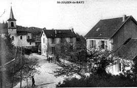 Saint-Julien-de-Raz in 1906 | |
 La Sure en Chartreuse Location within Auvergne-Rhône-Alpes region  La Sure en Chartreuse | |
| Coordinates: 45°21′04″N 5°39′47″E / 45.351°N 5.663°ECoordinates: 45°21′04″N 5°39′47″E / 45.351°N 5.663°E | |
| Country | France |
| Region | Auvergne-Rhône-Alpes |
| Department | Isère |
| Arrondissement | Grenoble |
| Canton | Voiron |
| Intercommunality | CA Pays Voironnais |
| Area1 | 27.73 km2 (10.71 sq mi) |
| Population (2014)2 | 989 |
| • Density | 36/km2 (92/sq mi) |
| Time zone | UTC+1 (CET) |
| • Summer (DST) | UTC+2 (CEST) |
| INSEE/Postal code | 38407 /38134 |
|
1 French Land Register data, which excludes lakes, ponds, glaciers > 1 km2 (0.386 sq mi or 247 acres) and river estuaries. 2 Population without double counting: residents of multiple communes (e.g., students and military personnel) only counted once. | |
La Sure en Chartreuse is a commune in the department of Isère, southeastern France. The municipality was established on 1 January 2017 by merger of the former communes of Saint-Julien-de-Raz (the seat) and Pommiers-la-Placette.[1]
See also
References
| Wikimedia Commons has media related to La Sure en Chartreuse. |
- ↑ Arrêté préfectoral 2 September (in French)
This article is issued from
Wikipedia.
The text is licensed under Creative Commons - Attribution - Sharealike.
Additional terms may apply for the media files.