La Mure
| La Mure | ||
|---|---|---|
| Commune | ||
 Town hall | ||
| ||
 La Mure Location within Auvergne-Rhône-Alpes region  La Mure | ||
| Coordinates: 44°54′14″N 5°47′17″E / 44.9039°N 5.7881°ECoordinates: 44°54′14″N 5°47′17″E / 44.9039°N 5.7881°E | ||
| Country | France | |
| Region | Auvergne-Rhône-Alpes | |
| Department | Isère | |
| Arrondissement | Grenoble | |
| Canton | Matheysine-Trièves | |
| Intercommunality | La Matheysine | |
| Government | ||
| • Mayor (2014–2020) | Fabrice Marchiol | |
| Area1 | 8 km2 (3 sq mi) | |
| Population (2011)2 | 5,059 | |
| • Density | 630/km2 (1,600/sq mi) | |
| Time zone | UTC+1 (CET) | |
| • Summer (DST) | UTC+2 (CEST) | |
| INSEE/Postal code | 38269 /38350 | |
| Elevation |
720–1,204 m (2,362–3,950 ft) (avg. 886 m or 2,907 ft) | |
|
1 French Land Register data, which excludes lakes, ponds, glaciers > 1 km2 (0.386 sq mi or 247 acres) and river estuaries. 2 Population without double counting: residents of multiple communes (e.g., students and military personnel) only counted once. | ||

La Mure is a commune in the Isère département in southeastern France.
It is located 35 km (22 mi) south of Grenoble on the plateau Matheysin.
Population
| Historical population | ||
|---|---|---|
| Year | Pop. | ±% |
| 1793 | 2,147 | — |
| 1806 | 1,818 | −15.3% |
| 1821 | 1,933 | +6.3% |
| 1831 | 2,785 | +44.1% |
| 1841 | 3,106 | +11.5% |
| 1851 | 3,648 | +17.5% |
| 1861 | 3,628 | −0.5% |
| 1872 | 3,577 | −1.4% |
| 1881 | 3,526 | −1.4% |
| 1891 | 3,401 | −3.5% |
| 1901 | 3,377 | −0.7% |
| 1911 | 3,595 | +6.5% |
| 1921 | 3,711 | +3.2% |
| 1931 | 4,423 | +19.2% |
| 1946 | 4,922 | +11.3% |
| 1954 | 5,595 | +13.7% |
| 1962 | 6,111 | +9.2% |
| 1968 | 6,196 | +1.4% |
| 1975 | 5,522 | −10.9% |
| 1982 | 5,657 | +2.4% |
| 1990 | 5,480 | −3.1% |
| 1999 | 5,190 | −5.3% |
| 2006 | 5,093 | −1.9% |
| 2011 | 5,059 | −0.7% |
Sights
- The Chemin de fer de la Mure is a small touristic train using a railway initially built for the transportation of coal between Saint-Georges-de-Commiers and La Mure. The line was inaugurated on 24 July 1888.
- The Arboretum de Combe Noire is a nearby arboretum created by teachers and staff
Personalities
- Saint Pierre-Julien Eymard, Roman Catholic priest founder of Congregation of the Blessed Sacrament and canonized in 1962, was born in la Mure on 4 February 1811.
Neighbouring communes
International relations
Twin towns – Sister cities
La Mure is twinned with:

See also
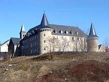
Le château de Beaumont
References
External links
| Wikimedia Commons has media related to La Mure. |
- La Mure official site in French
- Site of the plateau matheysin in French
- Site of the La Mure train and railway
- La Mure official tourism office in French
This article is issued from
Wikipedia.
The text is licensed under Creative Commons - Attribution - Sharealike.
Additional terms may apply for the media files.