Villard-Reymond
| Villard-Reymond | |
|---|---|
| Commune | |
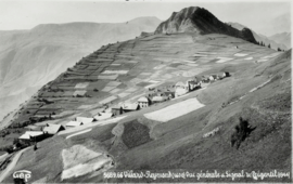 Villard-Reymond in 1937 | |
 Villard-Reymond Location within Auvergne-Rhône-Alpes region  Villard-Reymond | |
| Coordinates: 45°02′00″N 6°01′05″E / 45.0333°N 6.018°ECoordinates: 45°02′00″N 6°01′05″E / 45.0333°N 6.018°E | |
| Country | France |
| Region | Auvergne-Rhône-Alpes |
| Department | Isère |
| Arrondissement | Grenoble |
| Canton | Oisans-Romanche |
| Government | |
| • Mayor (2014–2020) | Chantal Theysset |
| Area1 | 11 km2 (4 sq mi) |
| Population (2012)2 | 36 |
| • Density | 3.3/km2 (8.5/sq mi) |
| Time zone | UTC+1 (CET) |
| • Summer (DST) | UTC+2 (CEST) |
| INSEE/Postal code | 38551 /38520 |
| Elevation |
840–2,732 m (2,756–8,963 ft) (avg. 1,600 m or 5,200 ft) |
|
1 French Land Register data, which excludes lakes, ponds, glaciers > 1 km2 (0.386 sq mi or 247 acres) and river estuaries. 2 Population without double counting: residents of multiple communes (e.g., students and military personnel) only counted once. | |
Villard-Reymond is a commune in the Isère department in southeastern France.
Population
| Historical population | ||
|---|---|---|
| Year | Pop. | ±% |
| 1793 | 265 | — |
| 1806 | 256 | −3.4% |
| 1821 | 273 | +6.6% |
| 1831 | 288 | +5.5% |
| 1841 | 247 | −14.2% |
| 1851 | 181 | −26.7% |
| 1861 | 179 | −1.1% |
| 1872 | 177 | −1.1% |
| 1881 | 188 | +6.2% |
| 1891 | 195 | +3.7% |
| 1901 | 185 | −5.1% |
| 1911 | 160 | −13.5% |
| 1921 | 106 | −33.8% |
| 1931 | 78 | −26.4% |
| 1946 | 51 | −34.6% |
| 1954 | 42 | −17.6% |
| 1962 | 21 | −50.0% |
| 1968 | 14 | −33.3% |
| 1975 | 7 | −50.0% |
| 1982 | 25 | +257.1% |
| 1990 | 21 | −16.0% |
| 1999 | 31 | +47.6% |
| 2006 | 47 | +51.6% |
| 2012 | 36 | −23.4% |
See also
References
| Wikimedia Commons has media related to Villard-Reymond. |
This article is issued from
Wikipedia.
The text is licensed under Creative Commons - Attribution - Sharealike.
Additional terms may apply for the media files.