Laffrey
| Laffrey | ||
|---|---|---|
| Commune | ||
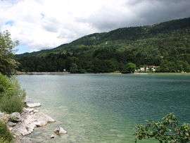 Laffrey Lake | ||
| ||
 Laffrey Location within Auvergne-Rhône-Alpes region  Laffrey | ||
| Coordinates: 45°01′30″N 5°46′22″E / 45.0250°N 5.7729°ECoordinates: 45°01′30″N 5°46′22″E / 45.0250°N 5.7729°E | ||
| Country | France | |
| Region | Auvergne-Rhône-Alpes | |
| Department | Isère | |
| Arrondissement | Grenoble | |
| Canton | Matheysine-Trièves | |
| Intercommunality | Sud Grenoblois | |
| Government | ||
| • Mayor (2014–2020) | Hélène Perrin | |
| Area1 | 6.72 km2 (2.59 sq mi) | |
| Population (2011)2 | 393 | |
| • Density | 58/km2 (150/sq mi) | |
| Time zone | UTC+1 (CET) | |
| • Summer (DST) | UTC+2 (CEST) | |
| INSEE/Postal code | 38203 /38220 | |
| Elevation | 680–1,262 m (2,231–4,140 ft) | |
|
1 French Land Register data, which excludes lakes, ponds, glaciers > 1 km2 (0.386 sq mi or 247 acres) and river estuaries. 2 Population without double counting: residents of multiple communes (e.g., students and military personnel) only counted once. | ||

Laffrey is a commune in the Isère department in southeastern France. It’s known for Napoleon passing through the town on march 7 1815.
Population
| Historical population | ||
|---|---|---|
| Year | Pop. | ±% |
| 1793 | 319 | — |
| 1806 | 365 | +14.4% |
| 1821 | 378 | +3.6% |
| 1831 | 436 | +15.3% |
| 1841 | 466 | +6.9% |
| 1951 | 510 | +9.4% |
| 1861 | 426 | −16.5% |
| 1872 | 431 | +1.2% |
| 1881 | 412 | −4.4% |
| 1891 | 404 | −1.9% |
| 1901 | 398 | −1.5% |
| 1911 | 326 | −18.1% |
| 1921 | 280 | −14.1% |
| 1931 | 307 | +9.6% |
| 1946 | 243 | −20.8% |
| 1954 | 265 | +9.1% |
| 1962 | 250 | −5.7% |
| 1968 | 238 | −4.8% |
| 1975 | 198 | −16.8% |
| 1982 | 211 | +6.6% |
| 1990 | 249 | +18.0% |
| 1999 | 311 | +24.9% |
| 2006 | 360 | +15.8% |
| 2011 | 393 | +9.2% |
See also
References
| Wikimedia Commons has media related to Laffrey. |
This article is issued from
Wikipedia.
The text is licensed under Creative Commons - Attribution - Sharealike.
Additional terms may apply for the media files.