Saint-Martin-de-Clelles
| Saint-Martin-de-Clelles | |
|---|---|
| Commune | |
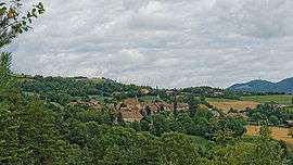 A general view of Saint-Martin-de-Clelles | |
 Saint-Martin-de-Clelles Location within Auvergne-Rhône-Alpes region  Saint-Martin-de-Clelles | |
| Coordinates: 44°50′47″N 5°37′01″E / 44.8464°N 5.6169°ECoordinates: 44°50′47″N 5°37′01″E / 44.8464°N 5.6169°E | |
| Country | France |
| Region | Auvergne-Rhône-Alpes |
| Department | Isère |
| Arrondissement | Grenoble |
| Canton | Matheysine-Trièves |
| Intercommunality | Canton of Clelles |
| Government | |
| • Mayor (2014–2020) | Robert Cartier |
| Area1 | 15 km2 (6 sq mi) |
| Population (2011)2 | 168 |
| • Density | 11/km2 (29/sq mi) |
| Time zone | UTC+1 (CET) |
| • Summer (DST) | UTC+2 (CEST) |
| INSEE/Postal code | 38419 /38930 |
| Elevation | 519–2,082 m (1,703–6,831 ft) |
|
1 French Land Register data, which excludes lakes, ponds, glaciers > 1 km2 (0.386 sq mi or 247 acres) and river estuaries. 2 Population without double counting: residents of multiple communes (e.g., students and military personnel) only counted once. | |
Saint-Martin-de-Clelles is a commune in the Isère department in southeastern France.
Population
| Historical population | ||
|---|---|---|
| Year | Pop. | ±% |
| 1793 | 249 | — |
| 1806 | 280 | +12.4% |
| 1821 | 230 | −17.9% |
| 1831 | 250 | +8.7% |
| 1841 | 313 | +25.2% |
| 1851 | 300 | −4.2% |
| 1861 | 304 | +1.3% |
| 1872 | 278 | −8.6% |
| 1881 | 269 | −3.2% |
| 1891 | 242 | −10.0% |
| 1901 | 180 | −25.6% |
| 1911 | 152 | −15.6% |
| 1921 | 108 | −28.9% |
| 1931 | 96 | −11.1% |
| 1946 | 93 | −3.1% |
| 1954 | 106 | +14.0% |
| 1962 | 82 | −22.6% |
| 1968 | 60 | −26.8% |
| 1975 | 70 | +16.7% |
| 1982 | 103 | +47.1% |
| 1990 | 122 | +18.4% |
| 1999 | 118 | −3.3% |
| 2006 | 146 | +23.7% |
| 2011 | 168 | +15.1% |
See also
References
| Wikimedia Commons has media related to Saint-Martin-de-Clelles. |
This article is issued from
Wikipedia.
The text is licensed under Creative Commons - Attribution - Sharealike.
Additional terms may apply for the media files.