Stanghella
| Stanghella | |
|---|---|
| Comune | |
| Comune di Stanghella | |
 Stanghella Location of Stanghella in Italy | |
| Coordinates: 45°8′N 11°45′E / 45.133°N 11.750°ECoordinates: 45°8′N 11°45′E / 45.133°N 11.750°E | |
| Country | Italy |
| Region | Veneto |
| Province | Province of Padua (PD) |
| Area | |
| • Total | 19.7 km2 (7.6 sq mi) |
| Population (Dec. 2004) | |
| • Total | 4,474 |
| • Density | 230/km2 (590/sq mi) |
| Time zone | UTC+1 (CET) |
| • Summer (DST) | UTC+2 (CEST) |
| Postal code | 35048 |
| Dialing code | 0425 |
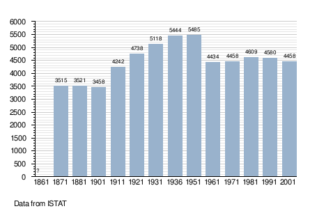
Stanghella is a comune (municipality) in the Province of Padua in the Italian region Veneto, located about 60 kilometres (37 mi) southwest of Venice and about 35 kilometres (22 mi) southwest of Padua. As of 31 December 2004, it had a population of 4,474 and an area of 19.7 square kilometres (7.6 sq mi).[1]
Stanghella borders the following municipalities: Boara Pisani, Granze, Pozzonovo, Solesino, Vescovana.
Demographic evolution
Twin towns
Stanghella is twinned with:

References

This article is issued from
Wikipedia.
The text is licensed under Creative Commons - Attribution - Sharealike.
Additional terms may apply for the media files.