Eybens
| Eybens | ||
|---|---|---|
| Commune | ||
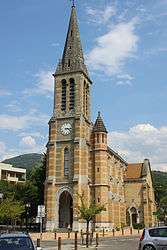 The church of Saint-Christophe, in Eybens | ||
| ||
 Eybens Location within Auvergne-Rhône-Alpes region  Eybens | ||
| Coordinates: 45°08′58″N 5°45′03″E / 45.1494°N 5.7508°ECoordinates: 45°08′58″N 5°45′03″E / 45.1494°N 5.7508°E | ||
| Country | France | |
| Region | Auvergne-Rhône-Alpes | |
| Department | Isère | |
| Arrondissement | Grenoble | |
| Canton | Échirolles | |
| Intercommunality | Grenoble-Alpes Métropole | |
| Government | ||
| • Mayor (2014–2020) | Francie Megevand | |
| Area1 | 4.50 km2 (1.74 sq mi) | |
| Population (2011)2 | 9,728 | |
| • Density | 2,200/km2 (5,600/sq mi) | |
| Time zone | UTC+1 (CET) | |
| • Summer (DST) | UTC+2 (CEST) | |
| INSEE/Postal code | 38158 /38320 | |
| Elevation | 216–408 m (709–1,339 ft) | |
|
1 French Land Register data, which excludes lakes, ponds, glaciers > 1 km2 (0.386 sq mi or 247 acres) and river estuaries. 2 Population without double counting: residents of multiple communes (e.g., students and military personnel) only counted once. | ||

Eybens is a commune in the Isère department in southeastern France.
Population
| Historical population | ||
|---|---|---|
| Year | Pop. | ±% |
| 1793 | 526 | — |
| 1806 | 619 | +17.7% |
| 1821 | 713 | +15.2% |
| 1831 | 866 | +21.5% |
| 1841 | 815 | −5.9% |
| 1851 | 810 | −0.6% |
| 1861 | 773 | −4.6% |
| 1872 | 819 | +6.0% |
| 1881 | 806 | −1.6% |
| 1891 | 822 | +2.0% |
| 1901 | 771 | −6.2% |
| 1911 | 791 | +2.6% |
| 1921 | 795 | +0.5% |
| 1931 | 1,295 | +62.9% |
| 1946 | 1,329 | +2.6% |
| 1954 | 1,756 | +32.1% |
| 1962 | 2,346 | +33.6% |
| 1968 | 3,310 | +41.1% |
| 1975 | 5,436 | +64.2% |
| 1982 | 5,843 | +7.5% |
| 1990 | 8,013 | +37.1% |
| 1999 | 9,471 | +18.2% |
| 2010 | 9,582 | +1.2% |
| 2011 | 9,728 | +1.5% |
See also
References
External links
| Wikimedia Commons has media related to Eybens. |
| Authority control |
|---|
This article is issued from
Wikipedia.
The text is licensed under Creative Commons - Attribution - Sharealike.
Additional terms may apply for the media files.