Crêts-en-Belledonne
| Crêts-en-Belledonne | |
|---|---|
| Commune | |
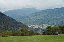 A view of Saint-Pierre | |
 Crêts-en-Belledonne Location within Auvergne-Rhône-Alpes region  Crêts-en-Belledonne | |
| Coordinates: 45°22′26″N 6°02′46″E / 45.374°N 6.046°ECoordinates: 45°22′26″N 6°02′46″E / 45.374°N 6.046°E | |
| Country | France |
| Region | Auvergne-Rhône-Alpes |
| Department | Isère |
| Arrondissement | Grenoble |
| Canton | Le Haut-Grésivaudan |
| Intercommunality | CC Le Grésivaudan |
| Area1 | 33.80 km2 (13.05 sq mi) |
| Population (2013)2 | 3,283 |
| • Density | 97/km2 (250/sq mi) |
| Time zone | UTC+1 (CET) |
| • Summer (DST) | UTC+2 (CEST) |
| INSEE/Postal code | 38439 /38830, 38570 |
|
1 French Land Register data, which excludes lakes, ponds, glaciers > 1 km2 (0.386 sq mi or 247 acres) and river estuaries. 2 Population without double counting: residents of multiple communes (e.g., students and military personnel) only counted once. | |
Crêts-en-Belledonne is a commune in the Isère department of southeastern France. The municipality was established on 1 January 2016 and consists of the former communes of Saint-Pierre-d'Allevard and Morêtel-de-Mailles.[1]
See also
References
| Wikimedia Commons has media related to Crêts en Belledonne. |
- ↑ Arrêté préfectoral 27 October 2015 (in French)
This article is issued from
Wikipedia.
The text is licensed under Creative Commons - Attribution - Sharealike.
Additional terms may apply for the media files.