Montchaboud
| Montchaboud | |
|---|---|
| Commune | |
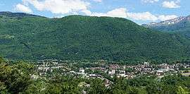 A general view of Montchaboud | |
 Montchaboud Location within Auvergne-Rhône-Alpes region  Montchaboud | |
| Coordinates: 45°05′43″N 5°45′46″E / 45.0953°N 5.7629°ECoordinates: 45°05′43″N 5°45′46″E / 45.0953°N 5.7629°E | |
| Country | France |
| Region | Auvergne-Rhône-Alpes |
| Department | Isère |
| Arrondissement | Grenoble |
| Canton | Oisans-Romanche |
| Intercommunality | Grenoble-Alpes Métropole |
| Government | |
| • Mayor (2014–2020) | Magdeleine Fasola |
| Area1 | 1.96 km2 (0.76 sq mi) |
| Population (2011)2 | 368 |
| • Density | 190/km2 (490/sq mi) |
| Time zone | UTC+1 (CET) |
| • Summer (DST) | UTC+2 (CEST) |
| INSEE/Postal code | 38252 /38220 |
| Elevation |
261–733 m (856–2,405 ft) (avg. 522 m or 1,713 ft) |
|
1 French Land Register data, which excludes lakes, ponds, glaciers > 1 km2 (0.386 sq mi or 247 acres) and river estuaries. 2 Population without double counting: residents of multiple communes (e.g., students and military personnel) only counted once. | |
Montchaboud is a commune in the Isère department in southeastern France.
Population
| Historical population | ||
|---|---|---|
| Year | Pop. | ±% |
| 1800 | 107 | — |
| 1806 | 77 | −28.0% |
| 1821 | 77 | +0.0% |
| 1831 | 76 | −1.3% |
| 1841 | 66 | −13.2% |
| 1851 | 77 | +16.7% |
| 8161 | 74 | −3.9% |
| 1872 | 72 | −2.7% |
| 1881 | 72 | +0.0% |
| 1891 | 62 | −13.9% |
| 1901 | 60 | −3.2% |
| 1911 | 47 | −21.7% |
| 1921 | 39 | −17.0% |
| 1931 | 37 | −5.1% |
| 1946 | 35 | −5.4% |
| 1954 | 40 | +14.3% |
| 1962 | 38 | −5.0% |
| 1968 | 52 | +36.8% |
| 1975 | 228 | +338.5% |
| 1982 | 310 | +36.0% |
| 1990 | 305 | −1.6% |
| 1999 | 335 | +9.8% |
| 2006 | 352 | +5.1% |
| 2011 | 368 | +4.5% |
See also
References
| Wikimedia Commons has media related to Montchaboud. |
This article is issued from
Wikipedia.
The text is licensed under Creative Commons - Attribution - Sharealike.
Additional terms may apply for the media files.