Voreppe
| Voreppe | ||
|---|---|---|
| Commune | ||
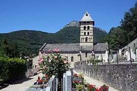 Church of Saint-Didier | ||
| ||
 Voreppe Location within Auvergne-Rhône-Alpes region  Voreppe | ||
| Coordinates: 45°17′55″N 5°38′15″E / 45.2986°N 5.6375°ECoordinates: 45°17′55″N 5°38′15″E / 45.2986°N 5.6375°E | ||
| Country | France | |
| Region | Auvergne-Rhône-Alpes | |
| Department | Isère | |
| Arrondissement | Grenoble | |
| Canton | Voiron | |
| Intercommunality | CA Pays Voironnais | |
| Government | ||
| • Mayor (2014–2020) | Luc Rémond | |
| Area1 | 28.65 km2 (11.06 sq mi) | |
| Population (2012)2 | 9,653 | |
| • Density | 340/km2 (870/sq mi) | |
| Time zone | UTC+1 (CET) | |
| • Summer (DST) | UTC+2 (CEST) | |
| INSEE/Postal code | 38565 /38340 | |
| Elevation |
185–1,702 m (607–5,584 ft) (avg. 249 m or 817 ft) | |
|
1 French Land Register data, which excludes lakes, ponds, glaciers > 1 km2 (0.386 sq mi or 247 acres) and river estuaries. 2 Population without double counting: residents of multiple communes (e.g., students and military personnel) only counted once. | ||
.svg.png)
Voreppe is a commune in the Isère department in southeastern France. The commune contains the Monastère de Chalais, a Dominican monastery about 7 kilometres (4.3 mi) from the town of Voreppe.
Population
| Historical population | ||
|---|---|---|
| Year | Pop. | ±% |
| 1793 | 2,395 | — |
| 1806 | 2,965 | +23.8% |
| 1821 | 2,521 | −15.0% |
| 1831 | 3,280 | +30.1% |
| 1841 | 3,005 | −8.4% |
| 1851 | 2,970 | −1.2% |
| 1861 | 2,887 | −2.8% |
| 1872 | 2,769 | −4.1% |
| 1881 | 2,886 | +4.2% |
| 1891 | 2,815 | −2.5% |
| 1901 | 3,005 | +6.7% |
| 1911 | 2,600 | −13.5% |
| 1921 | 2,426 | −6.7% |
| 1931 | 2,801 | +15.5% |
| 1946 | 2,611 | −6.8% |
| 1954 | 3,099 | +18.7% |
| 1962 | 3,617 | +16.7% |
| 1968 | 4,785 | +32.3% |
| 1975 | 5,995 | +25.3% |
| 1982 | 7,970 | +32.9% |
| 1990 | 8,446 | +6.0% |
| 1999 | 9,231 | +9.3% |
| 2006 | 9,615 | +4.2% |
| 2012 | 9,653 | +0.4% |
Twin towns
Voreppe is twinned with:


See also
References
| Wikimedia Commons has media related to Voreppe. |
| Authority control |
|---|
This article is issued from
Wikipedia.
The text is licensed under Creative Commons - Attribution - Sharealike.
Additional terms may apply for the media files.